- Brief description
-
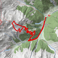
Tranquil low mountain hike – clockwise through meadows and woods of the Taistner Unterrain
Starting point: crossroad 100 m after the Hotel Alpen Tesitin in Taisten
Altitude difference: 260 m
Hiking time: 2 to 3 hours
Level of difficulty: easy and ideal terrain for snowshoe hiking
Important: Orientation in forest difficult when leaving marked path
Please note: this is only a snowshoe hike
Rest point: mountain restaurant Mudler Hof - Difficulty
-
easy
- Rating
-
- Route
-
Kuermle5.2 kmMudler5.7 kmBerggasthaus Mudler (1,584 m)5.7 km
- Best season
-
AugSepOctNovDecJanFebMarAprMayJunJul
- Description
-
Starting point is the crossroad 100 m after the Hotel Alpen Tesitin located above Taisten (on the way to the mountain restaurant Mudler Hof). From here, follow the Unterrainerstraße (cleared from snow in winter and numbered 21) for 3 km all the way to the Feichterhof at 1377 m. Once there, proceed uphill with your snowshoes on; depending on snow conditions either keep to the edge of the forest (trail number 21) or hike through the forest (trail 21 a) all the way to the hidden Kirmlehof at 1577 m. Follow the access road of the farm till it crosses the road leading to the mountain restaurant Mudler Hof (worthwhile rest point); now continue south-eastwards by keeping to the road until the snowshoe signs clearly point to the right and into the forest. Now in south-easterly direction descend the woods and meadows all the way down to the starting point. Please take particular note of the signs in the forest! Alternative route from the crossing at Kirmle/Mudler Hof: continue on road number 31 and through the hamlet Guggenberg and return to the starting point.
- Highest point
- 1,572 m