
- Brief description
-
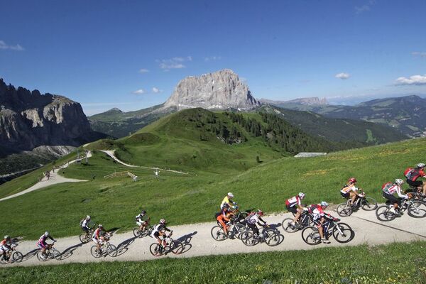
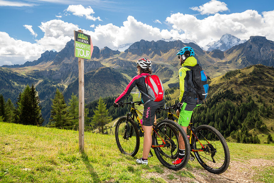
The Sellaronda MTB Tour is an excursion in mountain bike in an area of outstanding beauty around the "Sella" group in the Dolomites, declared a UNESCO World Heritage Site.
- Difficulty
-
difficult
- Rating
-
- Starting point
-
Center of "Arabba"
- Route
-
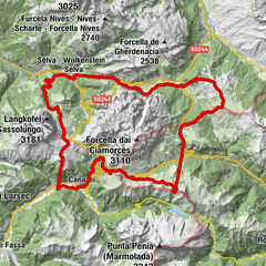
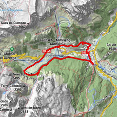
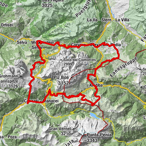
Dantercepies0.6 kmDantercepies (2,150 m)2.2 kmRestaurant Dantercepies2.8 kmGardena Pass (2,121 m)5.1 kmPlans - Frara8.4 kmMesoles9.7 kmRön (1,737 m)10.0 kmPecëi (1,672 m)10.8 kmKolfuschg (1,645 m)11.1 kmPezzei11.1 kmColfosco11.3 kmAdventure Park Calfosch11.6 kmSegh (1,522 m)12.8 kmBurjé13.4 kmKirche zum hl. Herz Jesu13.6 kmCorvara (1,568 m)13.6 kmCol Alto13.9 kmla flu14.1 kmCol14.1 kmCol Alto (2,000 m)14.9 kmÜtia Piz Arlara17.1 kmLa Para18.2 kmBiok (2,078 m)18.7 kmPralongià20.5 kmPralongiá (2,109 m)20.6 kmRifugio La Marmotta22.0 kmCampolongo25.9 kmLa Tambra26.0 kmHotel Boe26.3 kmKaiser Hütte27.8 kmRifugio Plan Boè29.5 kmArabba31.0 kmDMC Europa I (1,602 m)31.4 kmPortados (1,602 m)31.5 kmPescoi33.9 kmSass de la Vegla34.0 kmCèsa da Fuoch34.1 kmRifugio Luigi Gorza35.5 kmForcella Porta Vescovo35.7 kmPont de Vauz40.3 kmAlbergo Ristoro Lezuo44.5 kmBar Maria Ristorante46.1 kmFodom46.5 kmKanzenei53.9 kmCampitello di Fassa56.1 kmRifugio Des Alpes56.4 kmRodella des Alpes56.4 kmCol Rodella (2,485 m)58.5 kmBaita Miara Hütte60.1 kmRifugio Salei60.3 kmComici I65.3 kmPiz Seteur65.4 kmPudra68.7 kmPlan de Gralba69.0 kmValpudra69.1 kmDa Tamosso69.1 kmPiz Sella69.1 kmSenoner69.2 kmPlan (1,605 m)70.7 kmFrëina71.9 kmWolkenstein in Gröden72.8 kmBiancaneve73.1 kmCostabella74.0 kmDantercepies (1,646 m)74.9 km
- Best season
-
JanFebMarAprMayJunJulAugSepOctNovDec
- Description
-
Thanks to the use of the ski lifts, it is easier to reach the Dolomite passes "Val Gardena", "Campolongo", "Pordoi" and "Sella", and then enjoy a landscape that is as unique as it is rare, on paths and adrenaline-pumping descents.
- Directions
-
From the centre of "Arabba", head towards the top of the "Pordoi" pass and then descend on the other side to the junction with the "Sella" pass.
From here, descend to 'Pian de Gralba', from where you continue to Selva di Val Gardena to take the Costabella chairlift.
Once in "Corvara", cross the town and head towards the "Campolongo" pass, then descend again to "Arabba".
- Highest point
- 2,501 m
- Endpoint
-
Center of "Arabba"
- Height profile
-
 © outdooractive.com
 - Equipment
-
The mountain biker's kit:
merino wool T-shirt short trousers (shorts) long gloves anti-glare photochromatic glasses convertible helmet knee pads elbow pads flat shoes flat pedals - Safety instructions
-
Choose a route and speed that corresponds to your abilities, the condition of the land and routes, traffic signs, weather and ski lift opening times.
Always let someone know where you are going and the approximate duration of the hike and avoid going alone.
The telephone number in case of emergency is 112 or 118 (ambulance).
- Tips
-
This is a trail for expert moutain - bikers.
The vademecum of the "sustainable mountain biker":
choose the route according to your abilities find out about the accessibility conditions of the path respect the signs stay on the dedicated path moderate pace and speed (especially downhill) - Additional information
- Directions
-
By car
- From Innsbruck A22 Brennero highway to the Bressanone tool booth, continue through the Pusteria valley, Badia valley and the Campolongo Pass
- From Verona/Milan A22 Brennero highway up to Egna Ora tool booth, continue for Fiemme valley, Fassa valley, Pordoi Pass, Arabba
- From Venice A27 highwayway tool booth Belluno follow the Agordina 203 to Agordo, Caprile, Arabba
By train
Nearest railway stations
- Belluno - 70 km
- Brunico - 48 km
- Ponte Gardena - 51 km
By bus
- Brunico - 47 Km connection by SAD line www.sad.it
- Belluno - 70 km - connected by the Dolomitibus www.dolomitibus.it
By plane
- Venice Treviso/Venice Marco Polo - 160/170 km
- Innsbruck - 140 km
- Verona - 270 km
- Milan Bergamo/Milan Malpensa - 310/400 km
- Parking
-
Free parking is available near the "Porta Vescovo" cable car and near the Church of "Arabba".
-

-
AuthorThe tour "Sellaronda" MTB Clockwise is used by outdooractive.com provided.
General info
-
Dolomiten
194
-
Sellaronda
138
-
Pordoipass
73