Winter
Summer
Weather
Webcams
Accommodations
Tours
Search history
Search suggestions
No results found
Search
Tours
Home
Summer Österreich
Styria
Tours
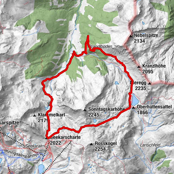
Vögeialm - Seekarscharte - Oberhüttensee
Regions
Weather
Webcams
Tours
Highlights
Bathing lakes
Accommodations
Offers
Sports provider
Events
Ski resorts
Cross-country skiing
Snow parks
Vögeialm - Seekarscharte - Oberhüttensee
Hiking
Bookmark
Map
show
hide
Print
Tour data
11.5
km
1,383 - 2,084
m
Distance
683
hm
701
hm
Ascent
02:55
h
Duration
Birgit.Kaiser
created am 09.08.2016
3,452
Views
Difficulty
difficult
Highest point
2,084 m
3,0
Write a review
Overall rating
5
0
%
4
0
%
3
100
%
2
0
%
1
0
%
Reviews
3,0
(1)
0 Comments
Write a review
Error
An error has occurred. Please try again.
Thank you for your review
Rating has been deleted
Report tour
GPS Downloads
GPX
GPS Exchange Format (XML)
KML
Google Earth, Google Maps
QR Download Codes for Mobile Phones
Vögeialm - Seekarscharte - Oberhüttensee
QR Codes - tour download for cell phones
GPX
KML
Other tours in the regions
Katschberg Lieser-Maltatal
2555
Obertauern
1640
Untertauern
504
Popular tours in the area
Mosermandl (2680m)
difficult
Hiking
16.34
km |
1442
hm |
06:45
h
Silberkarklamm
medium
Hiking
4.82
km |
329
hm |
03:30
h
Riesach Wasserfälle
Hiking
4.73
km |
292
hm |
03:00
h
Steirische and Lungauer Kalkspitze summits via Kranzl
difficult
Hiking
10.91
km |
926
hm |
05:10
h
No entries found.
The search is currently not available.
Please refine your search.
Local search results
(<= 25km)
More results
(> 25km)
%count% Search results
%name%
%type%
%elevation%
%population%
%lpButton%