


- Brief description
- Difficulty
-
difficult
- Rating
-
- Starting point
-
Teichalm, Hotel "Teichwirt"
- Route
-
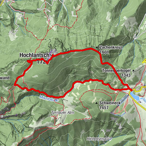
Almgasthof Teichwirt (1,200 m)0.0 kmZachenkreuz (1,601 m)2.1 kmHochlantsch (1,720 m)3.7 kmSchüsserlbrunn5.0 kmSteirischer Jokl5.1 kmZum Guten Hirten (1,206 m)6.4 kmOchsenbodenloch9.1 kmGaston-Lippitt-Hütte (1,200 m)10.9 kmAlmgasthof Teichwirt (1,200 m)11.4 km
- Best season
-
JanFebMarAprMayJunJulAugSepOctNovDec
- Description
-
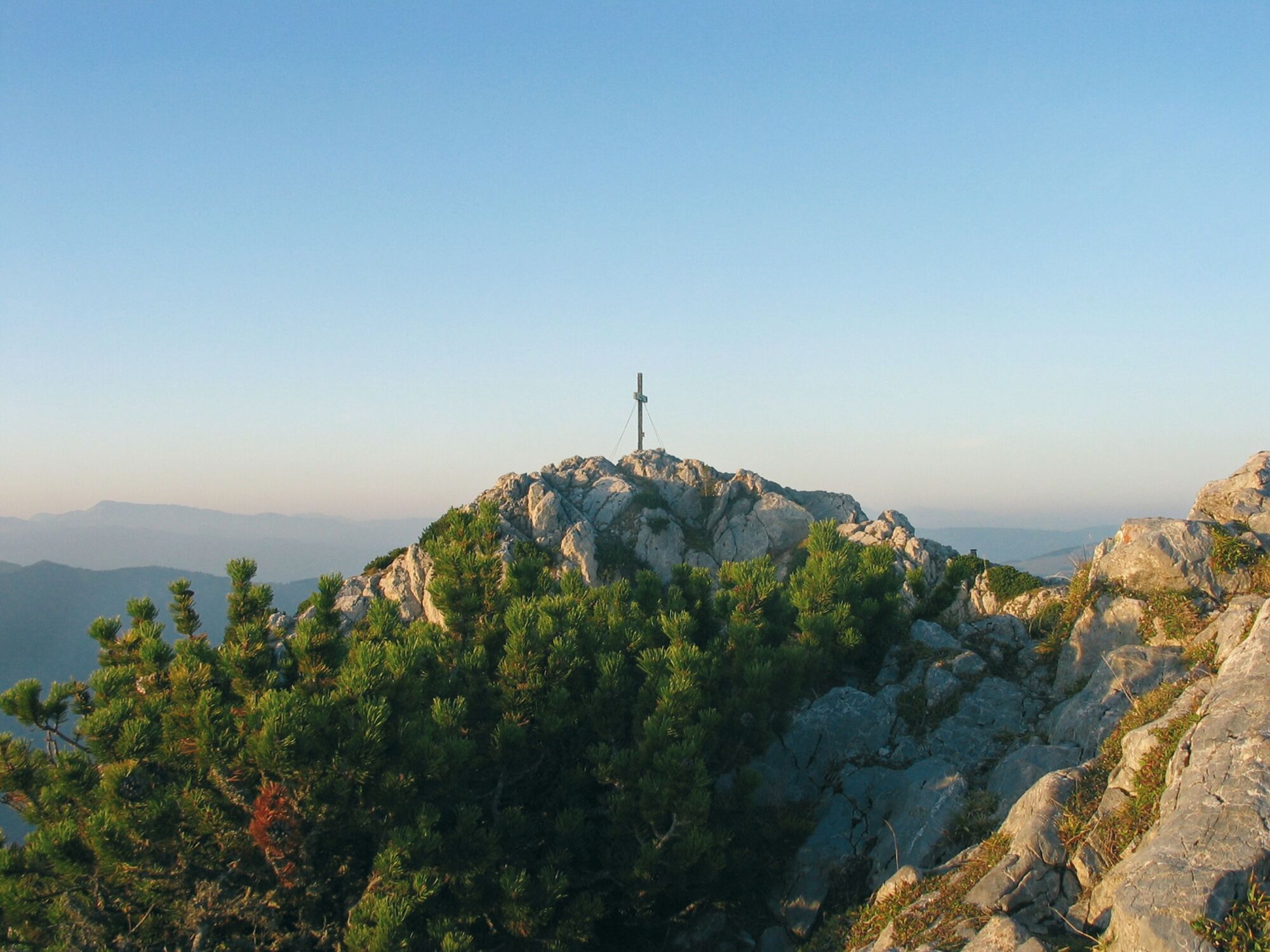
The starting point is the idyllic Teichalmsee, which, surrounded by gentle alpine pastures, forms the heart of the nature park. The wooden ox, the landmark of the Almenland beef region, stands directly at the lake, and the Teichalm moor with its nature trail also borders directly on the lake. The entrance to the trail on the Hochlantsch is just behind the Teichwirt Inn. With its 1,720 m, the Hochlantsch is after all the highest elevation in the Grazer Bergland. On clear days the view is magnificent and reaches as far as Hungary or Slovenia.The descent down to the GH "Steirischer Jockl" is quite steep, but well secured. From here, 198 steps lead down from the little wooden church of Schüsserlbrunn, which nestles closely against the rock face. It takes almost half an hour to reach the inn "Zum Guten Hirten", from where the pleasant path leads along the Mixnitzbach stream back to the Teichalm.
- Directions
-
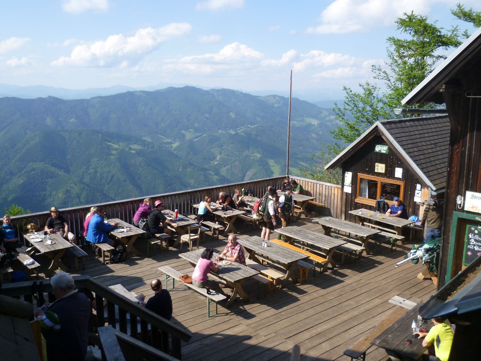
We start at the Teichalm, the entrance to trail no. 740 is right at the Teichwirt Inn. We now walk for approx. 2 hours across meadows and forests up to the Hochlantsch summit. The descent leads over stony terrain (trail no. 740) down to the "Steirischer Jockl" inn and the Schüsserlbrunn pilgrimage church. Once on the terrace of the inn, 99 steps lead steeply down to Schüsserlbrunn on the right. The way back to the Teichalm now leads down to the Mixnitzbach, we orientate ourselves by the signposts to the "Teichalm" (trail no. 746 and then trail no. 3). Now we walk for another hour almost level along the Mixnitzbach to the Teichalmsee (trail no. 745/702).
Refreshment stops:
GH "Steirischer Jockl" (open from 1 May to 31 October).
Zum Guten Hirten" inn (requires a small diversions, open from 1 May to 31 October).
Variants:
Hochlantsch circuit (without Bärenschützklamm):
Walking time: approx. 4.5 hrs. or 11 km, 550 m altitude difference
Trail 740: from the Teichalmsee to the Hochlantsch and further to the inn "Steirischer Jokl Trail 746: from the inn "Steirischer Jokl" down to the rest stop "Zum Guten Hirten". Trail 745: from the "Guten Hirten" along the Mixnitzbach back to the TeichalmHochlantsch circuit with Bärenschützklamm:
ATTENTION: The Bärenschützklamm will remain closed for construction work in 2022, the reopening is planned for May 1, 2023!
Walking time: approx. 7 hrs. or 17 km, 1,060 m altitude difference
Trail 740: from the Teichalmsee to the Hochlantsch and further to the inn "Steirischer Jockl" Trail 746: from the inn "Steirischer Jockl" down to the rest stop "Zum Guten Hirten". Trail 746: from the "Guten Hirten" down the "Prügelweg" to Schwaigeralm Trail 2: branch off from the Schwaigeralm to the gorge entrance at the Hans Kerl hut Trail 745: up the steep tracks in the gorge to the "Guten Hirten" and along the Mixnitzbach back to the TeichalmThe Bärenschützklamm is open from May 1 to October 31, a trail maintenance fee of € 3.50 is payable at the entrance to the gorge (as of April 2020).
Bärenschützklamm, starting from the Teichalm (without Hochlantsch):
ATTENTION: The Bärenschützklamm will remain closed for construction work in 2022, the reopening is planned for May 1, 2023!
Walking time: approx. 5.5 hrs. or 15 km, 470 m altitude difference
Trail 745: from the Teichalm (entrance at the Teichalm lifts) along the Mixnitzbach to the inn "Zum Guten Hirten" Trail 746: from the "Guten Hirten" down the "Prügelweg" to Schwaigeralm Trail 2: branch off from the Schwaigeralm to the gorge entrance at the Hans Kerl hut Trail 745: up the steep tracks in the gorge to the "Guten Hirten" and along the Mixnitzbach back to the TeichalmThe Bärenschützklamm is open from May 1 to October 31, a trail maintenance fee of € 5.00 must be paid at the entrance to the gorge (as of May 2020).
- Highest point
- 1,709 m
- Endpoint
-
Teichalm, Hotel "Teichwirt"
- Height profile
-

- Equipment
-
Take appropriate food and sufficient water with you - or check the refreshment stops (with opening hours!) along the way.
A good hiking boot is a good companion and should never be missing.
Emergency equipment (blister plasters!) belongs in every rucksack. Dress according to the "onion principle" and don't forget rain protection.
Sunglasses, sunscreen, hiking map & camera.
- Safety instructions
- Tips
-
For the "Great Women's Day" on 15 August, many pilgrims walk to Schüsserlbrunn, the highlight is the pilgrims' mass, afterwards there is a party at the "Steirischer Jockl"!
- Additional information
- Directions
- Public transportation
- Parking
-
There are parking spaces around the Teichalmsee


-

-
AuthorThe tour Hochlantsch Hiking Tour is used by outdooractive.com provided.


General info
-
Hochsteiermark
4066
-
Naturpark Almenland
1766
-
Breitenau am Hochlantsch
438


