- Brief description
-
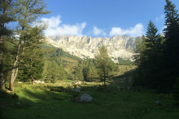
Along the river Salza, this hike leads through the gorge - a refreshing circular hike for hot summer days!
- Difficulty
-
medium
- Rating
-
- Starting point
-
Mariazell
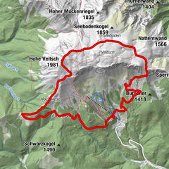
- Route
-
Mariazell0.0 kmMichaelskapelle0.1 kmSt. Josef0.1 kmRasing5.8 kmMariazell7.3 kmMichaelskapelle7.5 kmSt. Josef7.5 km
- Best season
-
JanFebMarAprMayJunJulAugSepOctNovDec
- Description
-
The Salzaklamm is one of the top 5 power places in Mariazell Land: Treat yourself to your personal time-out with a cozy picnic at the power places of Mariazell Land. Power places have a striking, unique appearance and possess a special energy.
Comfortable, but in places challenging hike through a narrow, romantic forest valley, marked throughout. Ideal for families, but smaller children need a little support from time to time on the partly narrow paths (a back carrier would be ideal).At the end of the gorge there is the possibility to branch off to the "Gußwerker Rundwanderung".
>> Here you can find a photo report of the hike from the Mariazellerland Blog!
- Directions
-
We walk from Mariazell through the Wr. Neustädterstraße to the Kreuzberg - at the foot of the Kreuzberg we turn right into the Salzaklamm (No. 12) and walk along the river through the gorge - at the end of the gorge we turn right to the Annaburg (settlement) and come across the Erzherzog Johann Weg, then following the B21 for a bit (sidewalk) to the P3. We pass the minigolf course and walk up the Abt Severingasse until we are back on the Wiener Neustädterstraße.
The hike into the Salzaklamm leads along the power-giving river Salza. Tall trees provide shade and nature shows its most beautiful side. A beautiful path through a narrow, romantic forest valley!
- Highest point
- 878 m
- Endpoint
-
Mariazell
- Height profile
-

- Equipment
-
Proper backpacking makes many things easier: pack heavy things first. The water bottle should always be within easy reach in a side pocket. All things that are often needed, such as sunglasses, camera or hiking map, belong on top. An emergency kit including blister plaster belongs in every backpack and dressing according to the "onion system" is always recommended!
Along the way: Girls willing to marry have to go through "Luckertes Kreuz" at "Kreuzberg" according to old folk belief praying three or nine times to get a good husband.
- Safety instructions
-
The hike is not recommended in case of rain - there is a risk of slipping.
Emergency call mountain rescue: 140
Emergency message tip - give answers to the six W questions: What happened? How many injured? Where did the accident happen (possibly GPS coordinates)? Who is reporting (callback number)? When did the accident happen? Weather at the accident site?Safety tips for a carefree hiking trip with dog can be found here
- Tips
-
Don't forget swimwear on hot summer days!
- Additional information
- Directions
-
Coming from Bruck an der Mur via the B20 over the Seebergsattel and through Gußwerk. Always follow the course of the road.
Coming from St. Pölten via the B20 (Annaberg and Josefsberg) through Mitterbach and St. Sebastian.
Always follow the course of the road.
- Public transportation
- Parking


- Author
-
The tour Power place Salzaklamm is used by outdooractive.com provided.


-
Mostviertel
2453
-
Mariazellerland
1503
-
Mariazell
363