Stage 03 From Glacier to Wine North Route Stoderzinken - Bad Mitterndorf


- Brief description
-
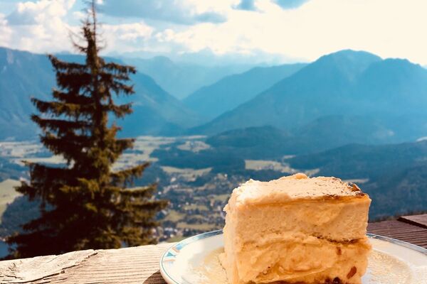
Through sparse larch forests and through the narrow, gloomy Notgasse, the trail leads us via the Brandalm to the Viehbergalm, a small, beautifully situated alpine village with several managed huts. Particularly well-known and popular is Marianne Gruber's Ritzingerhütte, which spoils hikers as well as mountain bikers with its homemade Steirerkrapfen. Over the Hochmühleck, a beautifully situated panoramic mountain, and through dense forests, this rather long stage leads downhill to Bad Mitterndorf in the Ausseerland Salzkammergut region.
- Difficulty
-
medium
- Rating
-
- Starting point
-
Stoderzinken
- Route
-
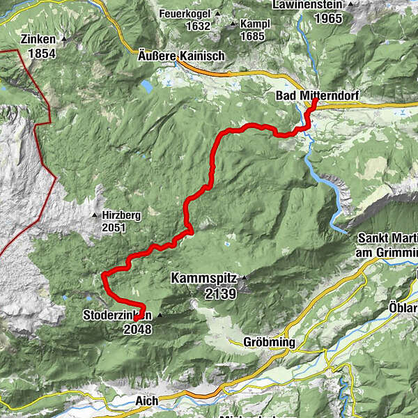
Stoder0.0 kmBerggasthof Steinerhaus0.2 kmBrünner Hütte1.0 kmNotgasse4.3 kmRiesgasse5.0 kmBrandalm6.1 kmHochmühleck (1,725 m)12.5 kmGrubegg20.4 kmBad Mitterndorf22.3 km
- Best season
-
JanFebMarAprMayJunJulAugSepOctNovDec
- Description
-
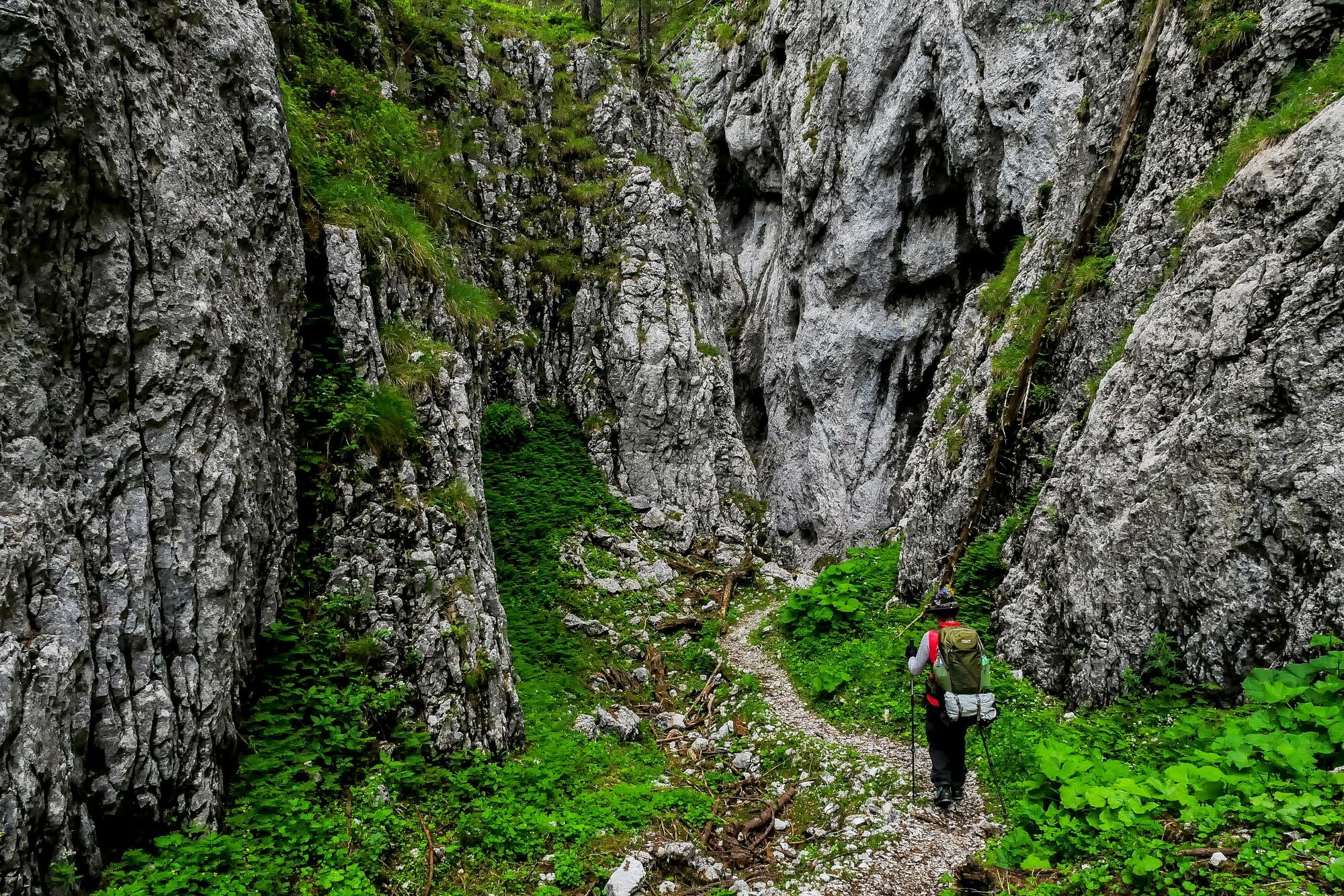
With the Notgasse an ancient mule and smuggler trail is on the agenda. It connects the Enns Valley with Hallstatt and in the times of the salt monopoly, salt was smuggled into the Enns Valley and to Ramsau am Dachstein and in return the Enns Valley and Ramsau miners brought Vogelbeerschnaps to the Hallstatt miners. In the Notgasse, however, you can also find old rock carvings, which are protected as historical monuments and date back to various epochs and are of inestimable historical value. The path can be somewhat difficult to walk on due to windfalls or similar influences of nature, as the processing of the wood is extremely difficult, but the path with its unique landscape is all the more impressive.
- Directions
-
At the foot of the Stoderzinken we should visit the Friedenskirchlein before the start of our actual tour. Only a 15 minutes walk away vfrom the parking lot, it offers a spectacular view of the mountains of the Schladminger Tauern. Peter Rosegger, the most famous local poet and writer of Styria, wrote on the occasion of the visit to the Friedenskirchlein: "What should I write in these mountains full of sunshine - I can only be silent in devotion and blissful." Those who are particularly good to themselves will also tackle the half-hour climb to the Stoderzinken, one of the most beautiful photo spots in the Enns Valley. However, please remember that we still have a nearly 21 km long stage ahead of us.
On this stage of the hiking route "From Glacier to Wine", a part of the Dachstein Guttenberghaus - Stoderzinken stage is on the program for us at the beginning: the descent through a sparse larch forest to the Notgasse. The turnoff from the 618 path to the Notgasse is located in the valley floor below the Kimpflingsattel and is well signposted. From here we continue through a forest with beautiful clearings, where in former times charcoal was produced. On the way through the Notgasse, a very narrow rock gorge about 500 m long, we admire the old rock carvings up to 2,000 years old, some of which are already a bit weathered and some even unfortunately overdrawn. We follow this historic mule and smuggler's path, which is only 2 m wide in places and is accompanied by rock walls up to 60 m high, and reach the Brandalm via a subsequent new forest path. This route is identical to the Dachstein circular hiking trail, which is marked by clearly visible yellow signs, as it was on the Dachstein Guttenberghaus - Stoderzinken stage. On the so-called Bettlersteig, the trail now leads uphill through a dense high forest to the Viehbergalm, an alpine village located at 1,445 m above sea level, which offers several places to stop for refreshments. The Ritzingerhütte (Tel. +43 0685 22474 or +43 676 9459817) is particularly popular for its fresh Steirerkrapfen, baked in hot lard and served with Steirerkas. If the Notgasse should be displaced by windfalls or similar, the beautifully laid out path No. 618 (and subsequently path No. 28) from the Brünnerhütte to the Viehbergalm is alternatively on the program.
Via the Hochmühleck, which offers us a beautiful view of the lonely Kemetgebirge on the eastern edge of the Dachstein plateau, we continue parallel to the Dachstein circular hiking trail steeply downhill to the Goseritzalm. From here, the trail leads us through a beautiful forest ever so slightly downhill to a trail junction in the immediate vicinity of the Steinitzenalm (Tel. +43 664 75057479), where we leave the Dachstein circular hiking trail. We keep to the right and cross the Almgraben to reach the Grimming Therme in Bad Mitterndorf, our stage stop (Tourist Information Tel. +43 3623 2444) . With its range of indoor and outdoor pools as well as relaxation areas with views of the Grimming, the Therme is a welcome change and reward for our calves. The next day we have the choice: either we hike to the Tauplitzalm, our next stage location, via the main route or we take the variant via Tauplitz with the chairlift ascent to the Tauplitzalm.
- Highest point
- 1,825 m
- Endpoint
-
Bad Mitterndorf
- Height profile
-

- Equipment
-
Proper backpack packing makes many things easier: Pack heavy things first. The water bottle should always be within reach in a side pocket. All the things that are often needed, such as sunglasses, camera or hiking map, belong on top. An emergency kit, including blister plasters, belongs in every rucksack and it is always advisable to dress in layers.
- Safety instructions
-
Emergency call mountain rescue: 140
Tips when reporting an emergency – Answer these six WH questions: What happened? How many people are injured? Where did the accident happen (are there GPS coordinates)? Who is reporting the incident (callback number)? When did the accident happen? What is the weather like at the site of the incident?
- Additional information
-
Steiermark Tourismus
Tel. +43 316 4003
If you would like to hire a tour operator, simply book with Steiermark Touristik, the official travel agency of Steiermark Tourismus:
Tel. +43 316 4003 450,
The Steiermark Touren app, available free of charge on Google Play and the App Store (Android, iOS), offers detailed first-hand information: brief facts (length, duration, difficulty, ascent and descent/elevation gain, ratings), map, route descriptions, altimeter, compass, peak finder, navigation along the tour. You can also create your own personal lists of favourite tours and sites, store tours and destinations offline, use social media channels, and much more.
- Public transportation
-
Detailed information about arriving by ÖBB (Austrian Federal Railways) can be found at www.oebb.at or on the Verbundlinie Steiermark website www.busbahnbim.at
With Verbundlinie’s BusBahnBim route planner app, planning your journey has never been easier: simply enter towns and/or addresses, stop names or points of interest to check all bus, train and tram connections in Austria. The app is available free of charge for smartphones – on Google Play and in the App Store
- Parking
-
The Stoderzinken Alpine Road leads from Gröbming directly to the Steiner Haus at the foot of the Stoderzinken, where our starting point is also located. This 11 km long panoramic road is the longest in Styria and offers magnificent views of the Hohe and Niedere Tauern mountains and from the Gesäuse mountains to the Großglockner.


-

-
AuthorThe tour Stage 03 From Glacier to Wine North Route Stoderzinken - Bad Mitterndorf is used by outdooractive.com provided.


General info
-
Ausseerland - Salzkammergut
3382
-
Gröbminger Land
1190
-
Gröbming
243