Winter
Summer
Weather
Webcams
Accommodations
Tours
Search history
Search suggestions
No results found
Search
Tours
Home
Summer Österreich
Styria
Tours
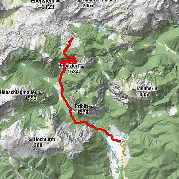
Tragöß-Oberort - Sonnschienhütte
Regions
Weather
Webcams
Tours
Highlights
Bathing lakes
Accommodations
Offers
Sports provider
Events
Ski resorts
Cross-country skiing
Snow parks
Tragöß-Oberort - Sonnschienhütte
Hiking
Bookmark
Map
show
hide
Print
Tour data
23.5
km
752 - 1,535
m
Distance
714
hm
714
hm
Ascent
07:00
h
Duration
gordito
created am 23.07.2014
4,582
Views
Difficulty
medium
Rating
Technique
Fitness
Landscape
Experience
Highest point
1,535 m
3,0
Write a review
Overall rating
5
0
%
4
50
%
3
0
%
2
50
%
1
0
%
Reviews
3,0
(2)
0 Comments
Write a review
Error
An error has occurred. Please try again.
Thank you for your review
Rating has been deleted
Report tour
GPS Downloads
GPX
GPS Exchange Format (XML)
KML
Google Earth, Google Maps
QR Download Codes for Mobile Phones
Tragöß-Oberort - Sonnschienhütte
QR Codes - tour download for cell phones
GPX
KML
Other tours in the regions
Erzberg Leoben
2530
Hochschwab
1272
Tragöß - Grüner See
471
Popular tours in the area
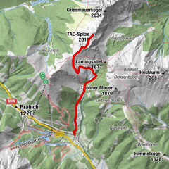
TAC Spitze - Vordernberger Grießmauer
medium
Hiking
4.55
km |
874
hm |
04:30
h
Trofaiach: Gößeck
medium
Hiking
11.6
km |
1282
hm |
06:00
h
Kaiserschild 2.084m, Kaiserwart 2.033m & Hochkogel 2.105m
medium
Hiking
12.6
km |
1363
hm |
06:30
h
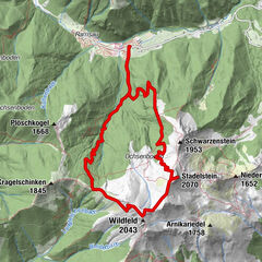
Eisenerz: Wildfeld und Stadelstein
Hiking
10.9
km |
1047
hm |
05:30
h
No entries found.
The search is currently not available.
Please refine your search.
Local search results
(<= 25km)
More results
(> 25km)
%count% Search results
%name%
%type%
%elevation%
%population%
%lpButton%


 & Kaiserschild (rechts)")