


- Brief description
-
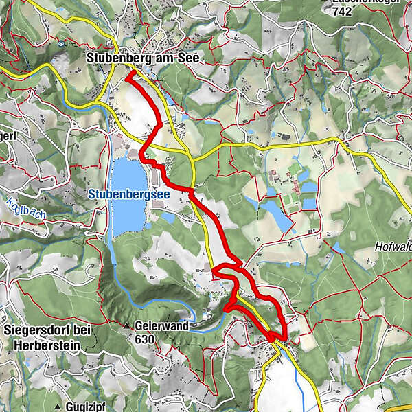
The hike takes you from the centre of Stubenberg to the leisure paradise at Lake Stubenberg, on to the Herberstein animal world and to St. Johann bei Herberstein.
- Difficulty
-
easy
- Rating
-
- Starting point
-
Village square Stubenberg
- Route
-
Stubenberg am SeeBachviertel0.8 kmBuchberg bei Herberstein2.4 kmMarienhof Herberstein3.4 kmSt. Johann bei Herberstein5.0 kmBachwirt Prettenhofer5.4 kmHüttenbüchel6.7 kmMarienhof Herberstein7.1 kmBuchberg bei Herberstein8.1 kmBachviertel9.6 kmStubenberg am See10.6 km
- Best season
-
JanFebMarAprMayJunJulAugSepOctNovDec
- Description
-
A leisurely hike in ApfelLand-Stubenbergsee in Eastern Styria.
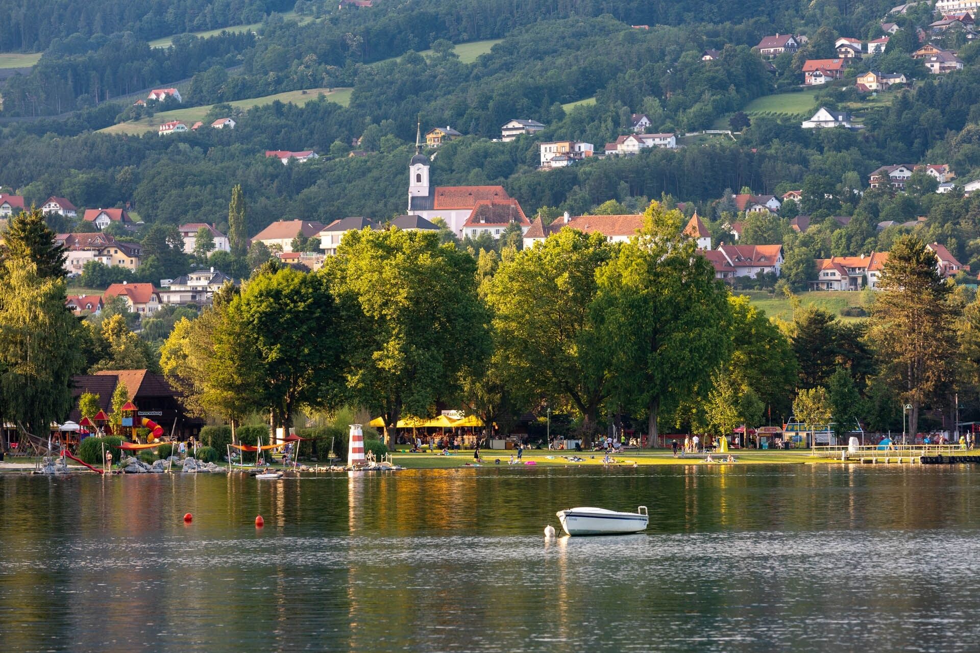
A wonderful view of the Stubenbergsee accompanies you for a long stretch of the trail. The hiking trail is partly marked with colour markings in red-white-red and additionally with signs "Herbersteinweg Nr.5". The starting point of the hike is at the Stubenberg municipal office, just behind the car park. Follow the dirt tracks between orchards and meadows in the direction of Stubenbergsee, past Boutique Hotel Erla and on to Gasthaus Steinmann. Follow the path until you come to the road, keep right here before crossing the road after approx. 100 metres. Then continue to Marienhof and Tierwelt Herberstein. From here follow the R8 to St. Johann bei Herberstein.
- Directions
-
The starting point of the hike is at the Stubenberg municipal office, just behind the car park.The hiking trail is partly marked with colour markings in red-white-red and additionally with signs "Herbersteinweg Nr.5". Walk along country lanes between orchards and meadows in the direction of Stubenbergsee.You come to the main road, on the right-hand side you will see the Tilp village smithy, here you cross the road and walk past the sports centre, then past Haus am See, Boutique Hotel Erla and on to Gasthaus Steinmann. Follow the path along the edge of the forest until you come to a road again, keep right here before crossing the road after approx. 100 metres.Then continue to the Marienhof where you can stop for a bite to eat.After a little refreshment, continue to Tierwelt Herberstein - a visit would be worthwhile.From Tierwelt Herberstein you walk along the R8 to St. Johann bei Herberstein. From Bachwirt Prettenhofer, you can first take hiking trail no. 5a on the way back, before returning to the starting point on trail no. 5 from Marienhof.
- Highest point
- 454 m
- Endpoint
-
Church St.Johann near Herberstein
- Height profile
-

- Equipment
-
Small rucksack with water bottle (+ provisions)Sturdy shoes
Appropriate clothing - preferably several layers - "onion principle"
Rain and sun protection
Hiking poles as required
Mobile phone
Small first aid kit
Route description
Before starting the hike, check where you can stop for refreshments, including opening times, or pack suitable provisions.
- Safety instructions
-
Important telephone numbers:
European emergency call: 112
Emergency call mountain rescue: 140 (if possible, please provide GPS data)
Rescue: 144
Fire brigade: 122
Police: 133
The trail is easy to walk and therefore suitable for the whole family. Tips for even more hiking fun: Rules of behaviour when hiking
- Tips
-
We recommend:
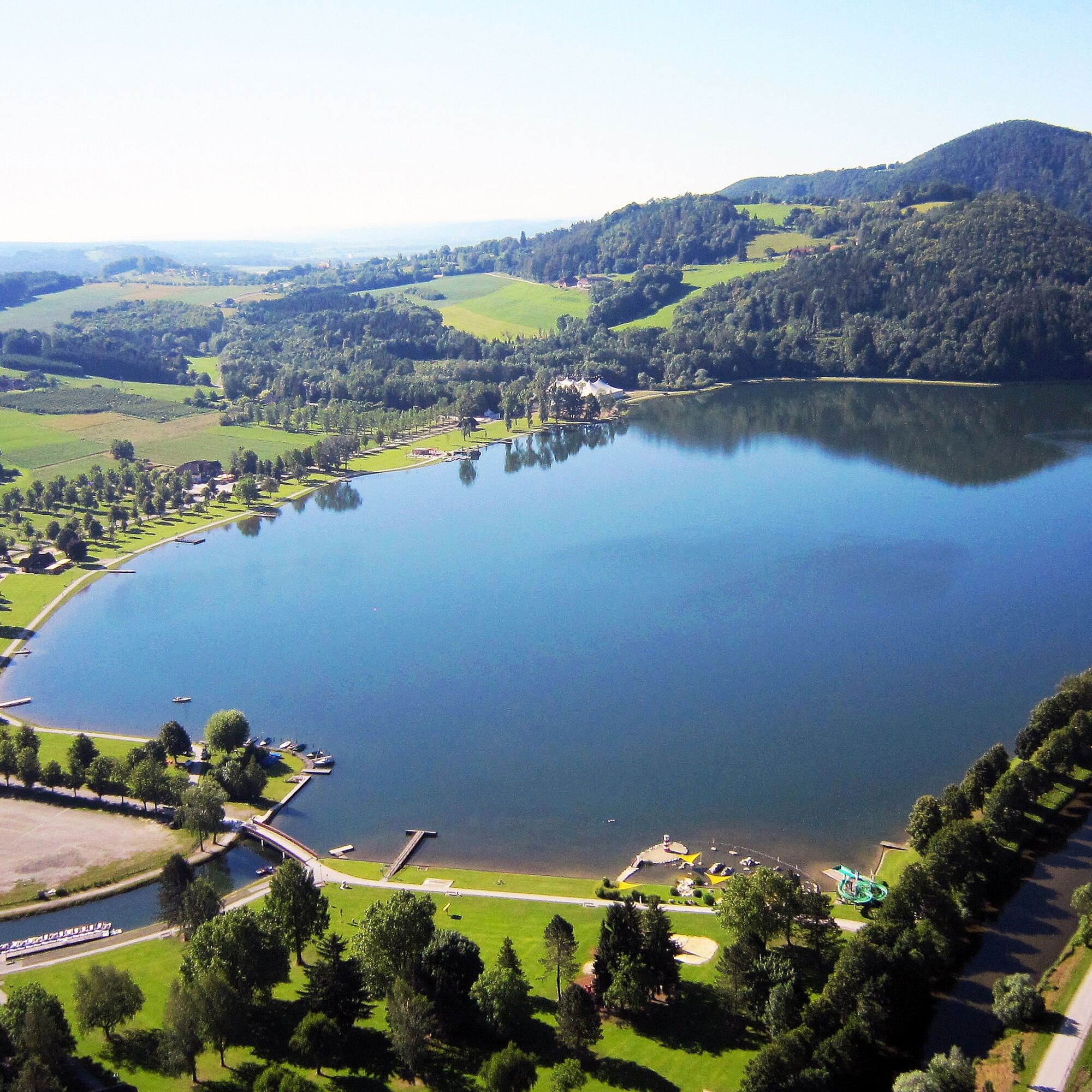
- Stubenbergsee
- Animal world and Herberstein Garden Castle
- Church of St. Johann near Herberstein
The ApfelLand Stubenbergsee offers us a very special experience.
Experience the region's sacred cultural treasures and church tours with the sound of the organ and bells using an audio guide.
Simply download the free "Hearonymus" app, select "Churches in ApfelLand-Stubenbergsee" under "Guides" and your smartphone has become an audio guide.
- Additional information
-
Information about the region, places to stop for refreshments and overnight accommodation, excursion destinations, etc:
Eastern Styria Tourist Board
ApfelLand-Stubenbergsee office
8223 Stubenberg am See 5
Tel. :+43 3176 8882
- Directions
-
ApfelLand is located in the heart of Eastern Styria, approx. 60 km north-east of Graz and approx. 140 km south of Vienna
By car:
Coming from Vienna: Via the south motorway (A2) to the Hartberg exit - via the main road (B54) towards Graz - 2 km after Kaindorf towards Graz, turn off towards ApfelLand-Stubenbergsee- Stubenbergsee
Coming from Salzburg/Germany:
Motorway via Salzburg - Pyhrnautobahn (A9) to Graz - continue via the Südautobahn in the direction of Vienna (A2) to the Gleisdorf West exit - main road (B54) to Kaibing - ApfelLand-Stubenbergsee- Stubenbergsee
- Public transportation
- Parking

-

-
AuthorThe tour Herberstein Way, Stubenberg is used by outdooractive.com provided.


-
Oststeiermark
2125
-
ApfelLand - Stubenbergsee
1141
-
Stubenberg am See
321


