- Brief description
- Difficulty
-
easy
- Rating
-
- Starting point
-
St. Ruprecht - Main Square
- Route
-
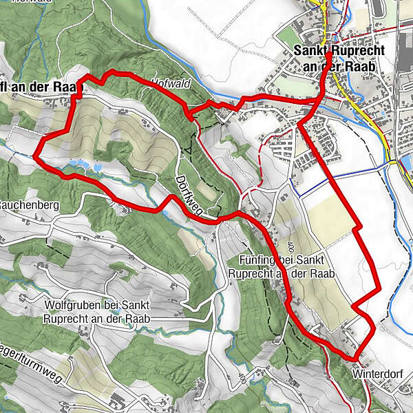
MariensäuleFriedensgrotte0.0 kmPfarrkirche hl. Ruprecht0.0 kmSankt Ruprecht an der Raab0.1 kmStefaniequelle1.2 kmDörfl an der Raab2.3 kmFünfing bei Sankt Ruprecht an der Raab4.8 kmSankt Ruprecht an der Raab7.5 kmMariensäule7.9 kmPfarrkirche hl. Ruprecht8.0 kmFriedensgrotte8.0 km
- Best season
-
JanFebMarAprMayJunJulAugSepOctNovDec
- Description
-
The Rauchenberg district in the west of St. Ruprecht an der Raab, which we visit on this circular hiking trail, is appreciated by hikers for its wealth of nature. When we leave the settlement area, the trail takes us through a dense forest to the Stefanie spring and further uphill to the district of Dörfl on a small ridge. From here we walk through an apple orchard to Rauchenberg, the namesake of the tour.
- Directions
-
First we start from the main square, the central starting point of the hike in St. Ruprecht an der Raab, past the café of the Locker & Legére hotel and the Strobl market wine tavern, where we soon turn slightly right onto the Raaballee - before the bridge over the Raab. This is also the start of the bee trail, which is popular for children. Continuing along the Raab, we reach a beautiful footbridge that leads us across the Raab to the tennis courts of the municipality. Here we keep to the right and after a few metres turn left into the forest past a tall electricity pylon. From here, the trail goes uphill: at the beginning in beautifully designed serpentines through a dense high forest to the Stefanie spring, whose romantic place invites you to take a first rest. You should also make a short detour here to the "Blessing Place" for children before following the trail. Then we climb a few steps to the crossroads, where we say goodbye to the Burgthannerweg, which has led parallel until then, because we keep to the right and continue hiking uphill through the high forest to reach the district of Dörfl, a small settlement on a ridge. We turn right and walk only a few metres along the settlement road and then turn left. The path continues downhill through a beautifully landscaped garden to the Dörflbach stream. At Dörflbach, we keep to the left and walk through a pleasantly shaded forest into the Rauchenberg district. We now walk slightly uphill along the road with little traffic to a prominent crossroads, where we keep straight on and after a few metres downhill turn right in the district of Fünfing. Here we walk past beautifully situated farms and houses to the next prominent road junction and keep left. From here we have a view of St. Ruprecht an der Raab with the unmistakable high church tower of the beautiful baroque church in the middle of the village. Past apple orchards and fields, the path leads us back to the starting point in the heart of St. Ruprecht an der Raab.
Marking:
Our hiking trails are marked red-white-red, as is common in the Alpine region, and at the crossing points there are yellow boards with black lettering and time indications. At the Burgthannerweg please follow the signs "Burgthannerweg". At the main square - the general hiking starting point in St. Ruprecht an der Raab - a stand with many yellow signs marks the direction. Our cycling and hiking map "A Region on the Move" is available at the municipal office, at the Raiffeisenbank St. Ruprecht an der Raab and at all catering and accommodation establishments.
- Highest point
- 479 m
- Endpoint
-
St. Ruprecht - Main Square
- Height profile
-

- Equipment
-
Backpack with drinking bottle/thermos jug and provisions
Mountain / hiking shoes
Appropriate clothing- possibly several layers- "onion principle" on cool days: long hiking trousers, gloves don't forget: headgear, sunglasses
Rain cover, seat pad
Wandering poles
Mobile phone
First aid kit
Route description, detailed map of the hike/hiking map/GPS device Before the start of the hike, refreshments incl. Check opening hours or pack appropriate food - Safety instructions
-
Important telephone numbers: Euronotall: 112 Emergency call mountain rescue: 140 (if possible please provide GPS data) Rescue: 144 Fire brigade: 122 Police 133
A few tips on how to behave correctly and fairly in the forest: (Source: www.bundesforste.at )
Hikers should avoid visits to the forest about 1.5 hours before sunrise and after sunset, as wild animals are particularly active during this time. Plastic bottles, handkerchiefs, cigarette butts & Co have lost nothing in the woods! Please make sure you don't leave any garbage in the woods. Camping and making a fire - is strictly forbidden in the forest! In principle, each person in the forest may collect 2 kg of mushrooms and berries per day for their own use. It is only forbidden if the forest owner expressly forbids it. - Tips
-
Visit the Peace Grotto, directly at St. Ruprecht's main square under the church steps.
Detour to the baroque church of St. Ruprecht an der Raab.
You can find refreshment in the numerous restaurants in St. Ruprecht an der Raab. - Additional information
- Directions
-
The market town of St.Ruprecht is located in Eastern Styria and is very easy to reach via the A2 motorway from Vienna (approx. 2 hours) and Graz (approx. 30 minutes).
- Arrival from Vienna and from Graz: On the A2 from Vienna and from Graz, take motorway exit 161 / Gleisdorf West in the direction of B54/B64. Follow the B65 / Gleisdorf federal road until you reach the B54 / Wechselbundesstraße. At the roundabout take the second exit to the B64 / Rechberg-Bundesstraße. After about 6 km turn left to St. Ruprecht an der Raab.
- Public transportation
- Parking


-

-
AuthorThe tour Rauchenbergweg, St. Ruprecht/Raab is used by outdooractive.com provided.