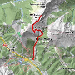
Tour data
4.86km
782
- 1,037m
392hm
392hm
03:00h

- Difficulty
-
medium
- Rating
-
- Route
-
Tragöß - OberortAntoniuskapelle0.0 kmAmbrosi Bründl1.3 kmKamplriedl2.3 km
- Best season
-
JanFebMarAprMayJunJulAugSepOctNovDec
- Highest point
- Klammhöhe (1,037 m)
GPS Downloads


Trail conditions
Asphalt
Gravel
Meadow
Forest
Rock
Exposed
Other tours in the regions
-
Erzberg Leoben
2529
-
Hochschwab
1272
-
Tragöß - Grüner See
471


 & Kaiserschild (rechts)")