- Brief description
-
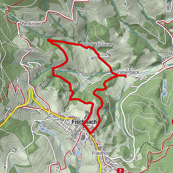
Circular route from the town down to the chapel at Grabenbäck via the Ägydius Chapel and then largely comfortably along a forest path back to the village square in Fischbach
- Difficulty
-
medium
- Rating
-
- Starting point
-
Fischbach village square
- Route
-
Kirchenwirt0.0 kmGasthof Fischbacherhof0.0 kmFischbach4.9 kmZum Forsthaus4.9 kmGasthof Fischbacherhof5.0 kmKirchenwirt5.0 km
- Best season
-
JanFebMarAprMayJunJulAugSepOctNovDec
- Description
-
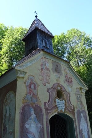
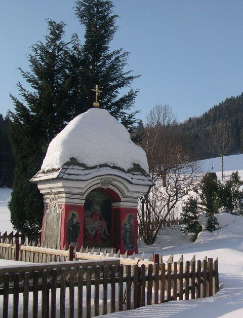
The Ägydius Chapel is a baroque architectural jewel from the 18th century next to a Hey spring, which is used for eye problems. The second chapel is that of the Zink family, who had the chapel lovingly restored in the 1990s. From there it goes along a forest path past some farms back to the village square in Fischbach.
- Directions
-
We walk next to the municipal office down following the signs to the Ägydius Chapel. The path leads steeply downhill to the Ägydius chapel, where there is a rest area at the bottom where you can take a break before we have to go straight back up the steep path and march down the forest path to the right (path no. 6) until we finally arrive in the small hamlet of Oberdissau and one of the oldest there You can admire the chapels of Fischbach. We can also take a break here, then we walk back about 100 m along the forest path number 6 a, past a few farms until we can enjoy the wide view at the Tonimbühel farm. Then we walk through a meadow path until we have to cross a small stream and initially walk along a narrower path. For those who are more fit, there is the option of hiking up a small steep path on the right and taking the Villenweg to Fischbach. Those who find this path too steep can continue along the forest path and come back to Fischbach at the gas station.
- Highest point
- 998 m
- Endpoint
-
Fischbach village square
- Height profile
-

- Equipment
-
Small backpack with water bottle (+ provisions)
Sturdy shoes
Appropriate clothing - if possible several layers - "onion principle".
Rain and sun protectionWalking sticks as required
Mobile phone
Small first aid kit
Route description
Before starting the hike, check the possibilities for refreshments, including opening times, or pack appropriate food and drink.
- Safety instructions
-
European emergency call: 112
Emergency call mountain rescue: 140 (if possible please provide GPS data)
Rescue: 144
Fire brigade: 122
Police: 133
A few tips on correct and fair behaviour in the forest: (Source: www.bundesforste.at )
Hikers should avoid visits to the forest about 1.5 hours before sunrise and after sunset, as wild animals are particularly active during this time.
Plastic bottles, handkerchiefs, cigarette butts etc. have no place in the forest! Please make sure that you do not leave any rubbish in the forest.
Camping and lighting fires are strictly forbidden in the forest!
In principle, every person is allowed to pick 2 kg of mushrooms and berries per day for personal use. It is only prohibited if the forest owner expressly forbids it.
- Tips
-
Test the healing power of the Ägydius Spring!
- Additional information
- Directions
- Public transportation
- Parking
- Author
-
The tour To the Ägydius Chapel and to Oberdissau - circular route is used by outdooractive.com provided.


General info
-
Hochsteiermark
4072
-
Joglland - Waldheimat
1511
-
Fischbach
361