- Brief description
-
Time spent hiking has given some philosophers brilliant ideas. Regal views and refreshing vistas await you on this hike.
- Difficulty
-
easy
- Rating
-
- Starting point
-
Graz Region Tourist Information, Herrengasse 16
- Route
-
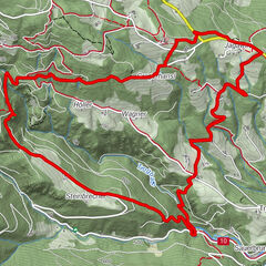
Luderbauer1.6 kmOrthacker4.1 kmAussichtsrampe4.4 kmRudolfswarte (658 m)4.9 kmBuchkogel (658 m)4.9 kmBuchkogelsattel (555 m)5.9 kmBuchkogelsattel (539 m)6.2 kmSankt Johann und Paul6.6 kmSchlosskirche Sankt Martin9.7 kmSankt Martin9.7 km
- Best season
-
JanFebMarAprMayJunJulAugSepOctNovDec
- Description
-
This tour has a lot of highlights. The "Schau West" platform is one of them. In the form of an arrow, it points out into the country and invites visitors not only to be amazed by the view, but also to reflect. Among other things, you can read the following proverb there: "You have to look for happiness on the way, not at the destination, that's where the journey ends." The detour to the herb farm store "Lienhof" is an absolute recommendation. Here you can find herbal mixtures in jars, regional specialties, as well as fruits and vegetables. Another highlight of this tour is the Kronprinz Rudolfwarte, which offers a great panoramic view of the Graz region. Just a few minutes' walk away is the idyllic little church of St. John and Paul. From here you can again enjoy a great view of Graz and the surrounding area.
- Directions
-
From the Graz Region Tourist Information, turn south and walk to Jakominiplatz. From there take the city bus route 32 towards Seiersberg. After 20 minutes you reach Bad Strassgang station. If you walk towards Hans-Hegenbarth-Alle, you will reach Bad Strassgang after a few minutes’ walk. Continue along Martinhofstraße and turn left onto Am Katzelbach. Shortly afterwards, another path branches off to the left into the forest. Follow the path steadily uphill and after a while you will come to Florianibergstraße. Take a detour to “Florianikirche”, visit “Gasthaus Luderbauer” or the “Lienhof” farm shop or simply let yourself be inspired by the magical view of Western Styria. At the crossroads follow Wolfgangweg and the signpost to “Gasthaus Orthacker”. A little later you will reach another fork and walk on a forest path again towards Bildföhre or “Gasthaus Orthacker”. Afterwards, the forest path reaches the asphalted road again. Soon after, you catch sight of the beautifully situated traditional inn. Here you can enjoy Austrian home cooking on the wonderful terrace with a view of Graz. From there, the path leads left at the signpost back into the forest. Keep left here, you are almost at the next stop: the “Schau West” viewing platform, shaped like an arrow, invites visitors to marvel and refl ect. If you turn right and walk uphill a bit, you will reach the Crown Prince Rudolf observation point. The observation point was rebuilt in 1879 in honour of Crown Prince Rudolf. An iron spiral staircase leads up to a round viewing platform and iron railings, from where there is a particularly good view of the southern part of Graz. North of the observation point you come to Buchkogelsteig, which you follow to a playground and St. Johann and Paul’s church. A pilgrimage church named St. Johann am Kögelein was fi rst mentioned here as early as 1507. Go left through the playground and down a forest path to reach “Mostschänke Grießner”. Now follow Krottendorfer Straße to the beautiful “Schloss St. Martin”, which is an educational centre today, back to the starting point along Kehlbergstraße, past “Kehlberghof” into Salfeldstraße and Gradlbauerweg to Bad Strassgang, from where you take bus route 32 back to the city centre.
- Highest point
- 652 m
- Endpoint
-
Graz Region Tourist Information, Herrengasse 16
- Height profile
-

- Tips
-
Farm store Lienhof, platform "Schau West", Crown Prince Rudolfwarte, Church of St. John and Paul
- Arrival
-
For this tour it is recommended to travel by public transport!
- Public transportation
-
Getting there: Bus route 32 from Jakominiplatz towards Seiersberg
Getting back: Bus route 32 towards Jakominiplatz


- Author
-
The tour Buchkogel: the journey is the reward is used by outdooractive.com provided.


General info
-
Erlebnisregion Graz
2781
-
Graz und Region Graz
1524
-
Seiersberg-Pirka
500