
- Brief description
-
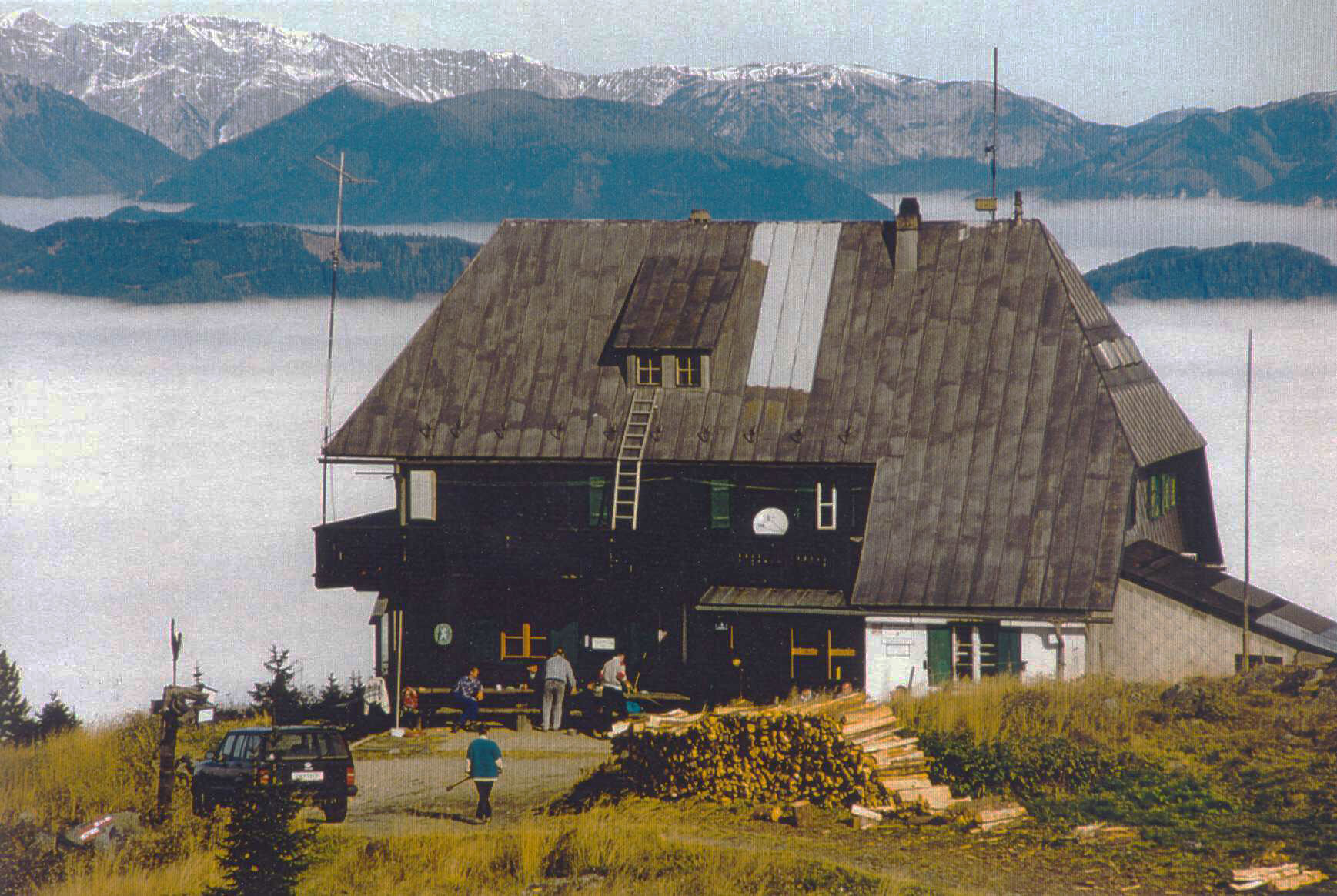
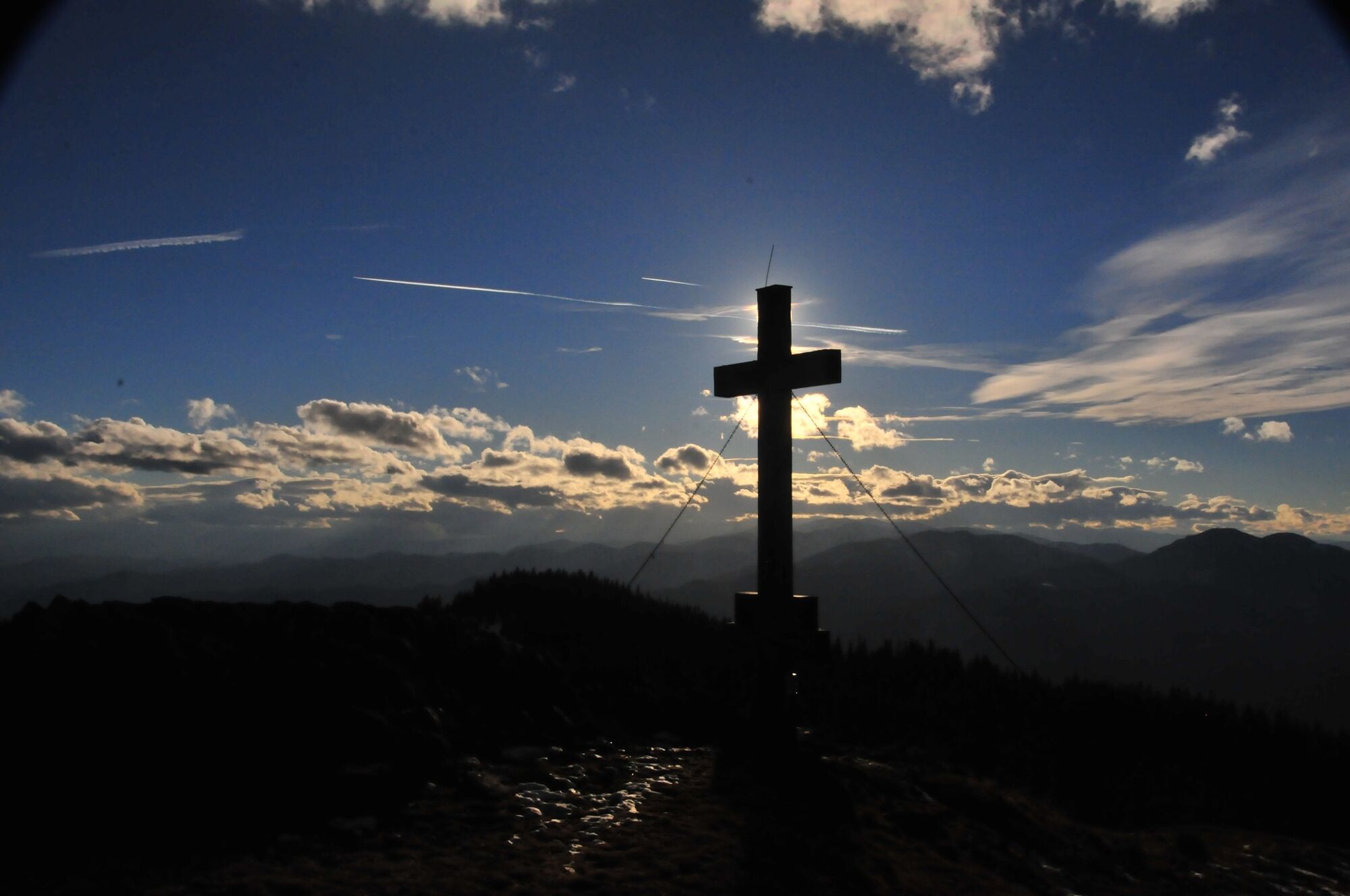
Today it is family-friendly and safe to climb the 1,629m high Rennfeld with the shelter of the same name located just below the summit. 110 years ago, the first shelter was built on the Rennfeld in Hochsteiermark, which had to be rebuilt in 1950 after a fire.
The exposed location at the highest point of the western Fischbach Alps allows a distant view as far as the glacier world of the Hohe Tauern, but also as far as the plains of the eastern Styrian thermal region. Thus, this hike in the footsteps of the High Styrian BergZeitReise becomes a Styrian panoramic journey and at the same time also an appetizer for the Styria-wide round trip "from glacier to wine".
- Difficulty
-
medium
- Rating
-
- Starting point
-
Depending on tour selection in Kapfenberg, Bruck an der Mur, Breitenau, Frauenberg or Pernegg
- Route
-
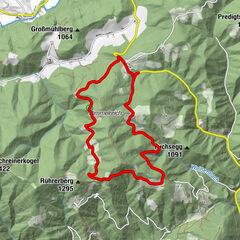
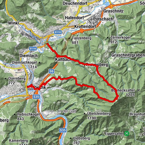
KapfenbergKaltbach1.9 kmEinkehr Prieselbauer2.0 kmGasthof Angerer Wirt4.7 kmFrauenberg4.7 kmOttokar-Kernstock-Haus8.0 kmRennfeld (1,629 m)8.3 kmGasthaus Hütter11.9 kmPischkberg14.0 kmHimmelwirt14.1 kmPischk16.2 kmWiener Vorstadt17.0 kmBruck an der Mur17.3 km
- Best season
-
JanFebMarAprMayJunJulAugSepOctNovDec
- Description
-
There are hardly any points from which you can overlook the entire High Styrian BergZeitReise - except from the Rennfeld summit!
And because the panorama of this quite easy to reach peak high above Bruck an der Mur and Kapfenberg is not enough, there is also one of the coziest mountain huts in all of High Styria just below it in a scenic location.
Breitenau, Pernegg, Bruck, Kapfenberg or Frauenberg?
Magnificent view, hospitable hut and easy accessibility - so it is not surprising that from several valley towns climbs of various lengths lead to the 1,629m high peak. But not only day hikes from the Mur and Mürz valleys are possible to this gentle summit. Also the two- to three-day traverse of the entire Fischbacher Alps to the 1,783m high Stuhleck starts here - or ends here, depending on which direction you choose.
- Directions
-
From leisurely to sporty
Well, we are not running at all today, but hiking leisurely through the vast forests to the free mountain top with the mighty summit cross. By the way, all hiking trails are well marked and signposted!
For those who prefer a more leisurely approach, we recommend the ascent from the Pischkalm (accessible on a narrow mountain road via the Glanzgraben from Bruck an der Mur, few P!).
Those interested in cultural history should plan their start in the small village of Frauenberg, because the pilgrimage church Maria Rehkogel there is worth a visit.
If you want to extend this tour a bit, you can also start at the imposing Oberkapfenberg Castle. From there it's about an hour to Frauenberg via the hospitable "Prieselbauer".
Return to the Murtal - real stamina bolts start their ascent from Pernegg in the Gabraungraben.Schneidige 1,150 vertical meters are to be covered from here to the summit. As a small compensation for the long ascent, a beautiful high-altitude hike awaits all eager hikers here in the upper part.
Let's stay in the southern part of the Rennfeld. From Breitenau, starting from the GH Obersattler, the Rennfeld peak can also be climbed. In the upper part of this ascent variant, the trail joins the Central Alpine Trail, which crosses Austria from east to west.
The Fischbach Alpine Crossing
And here we are already at the final tip - the crossing of the Fischbacher Alps from Rennfeld via Teufelstein, Stanglalm, the Waldheimat and the Pretul to Stuhleck. Two to three wonderfully quiet and safe hiking days on the tracks of the BergZeitReise.
Altitude meters ascent, total walking time see individual tours.
Huts: Rennfeld-Schutzhaus, Tel.: 03864/6761, please ask for future opening hours due to the current situation!
Family suitability: yes, from Pernegg quite long tour!
Ascent from Pischkalm: 440 Hm, 2-3 hours, few P!
Start in Frauenberg: 690 Hm, 3-4 hours
From Oberkapfenberg castle: 980 Hm, 4-5 hours
Ascent from Pernegg: 1.150 Hm, 5-6 hours
Start in Breitenau - GH Obersattler: 710 Hm, 3-4 hours
- Highest point
- 1,612 m
- Endpoint
-
Depending on tour selection in Kapfenberg, Bruck an der Mur, Breitenau, Frauenberg or Pernegg
- Height profile
-

- Equipment
-
Proper backpacking makes a lot of things easier:
Pack heavy things first. The water bottle should always be within easy reach in a side pocket. All things that are often needed, such as sunglasses, camera or hiking map, belong on top. An emergency kit including blister plaster belongs in every backpack and a clothing according to the "onion system" is always recommended!
Always use good, ankle-high shoes for all hikes! In winter, light crampons are recommended.
- Safety instructions
-
The entire path / the paths is / are safely walkable almost all year round, in winter proper clothing or snowshoe equipment necessary!
Emergency call mountain rescue: 140, www.bergrettung-stmk.at
Tip for emergency reporting - give answers to the six W-questions:What happened? How many injured? Where did the accident happen (possibly GPS coordinates)? Who is reporting (callback number)? When did the accident happen? Weather at the scene of the accident?
- Tips
-
The pilgrimage church Maria Rehkogel in Frauenberg, the castle Oberkapfenberg, the historic old town of Bruck an der Mur with the gothic Kornmesserhaus or the pilgrimage church in Pernegg.
- Additional information
-
www.hochsteiermark.at
www.steiermark.com
www.tourismus-bruckmur.at
The Styria Tours App, available for free on Google Play and in the App Store (Android, iOS), offers detailed first-hand information:
Shortfacts (length, duration, difficulty, ascent and descent in altitude meters, ratings), map, route descriptions, altimeter, compass, summit finder, navigation along the tour.
In addition, you can create your personal favorites list of favorite tours and points, save tours and destinations offline, play on social media channels and more.
- Public transportation
-
Nature Park Taxi in the Mürzer Oberland Nature Park: Tel.: +43 3857 20170, www.naturparktaxi.at
ÖBB www.oebb.at or Verbundlinie Steiermark www.busbahnbim.at
With the BusBahnBim App of the Verbundlinie a timetable information is easier than ever:
All connections by bus, train and streetcar in Austria can be queried by entering places and / or addresses, stops or important points. The app is available as a free app for smartphones (Android, iOS) - on Google Play and in the App Store.


-

-
AuthorThe tour BergZeitReise Tagetourentipp - Rennfeld is used by outdooractive.com provided.


General info
-
Hochsteiermark
4078
-
Bruckmur-Kapfenberg
1499
-
Frauenberg - Maria Rehkogel
429