- Brief description
- Difficulty
-
difficult
- Rating
-
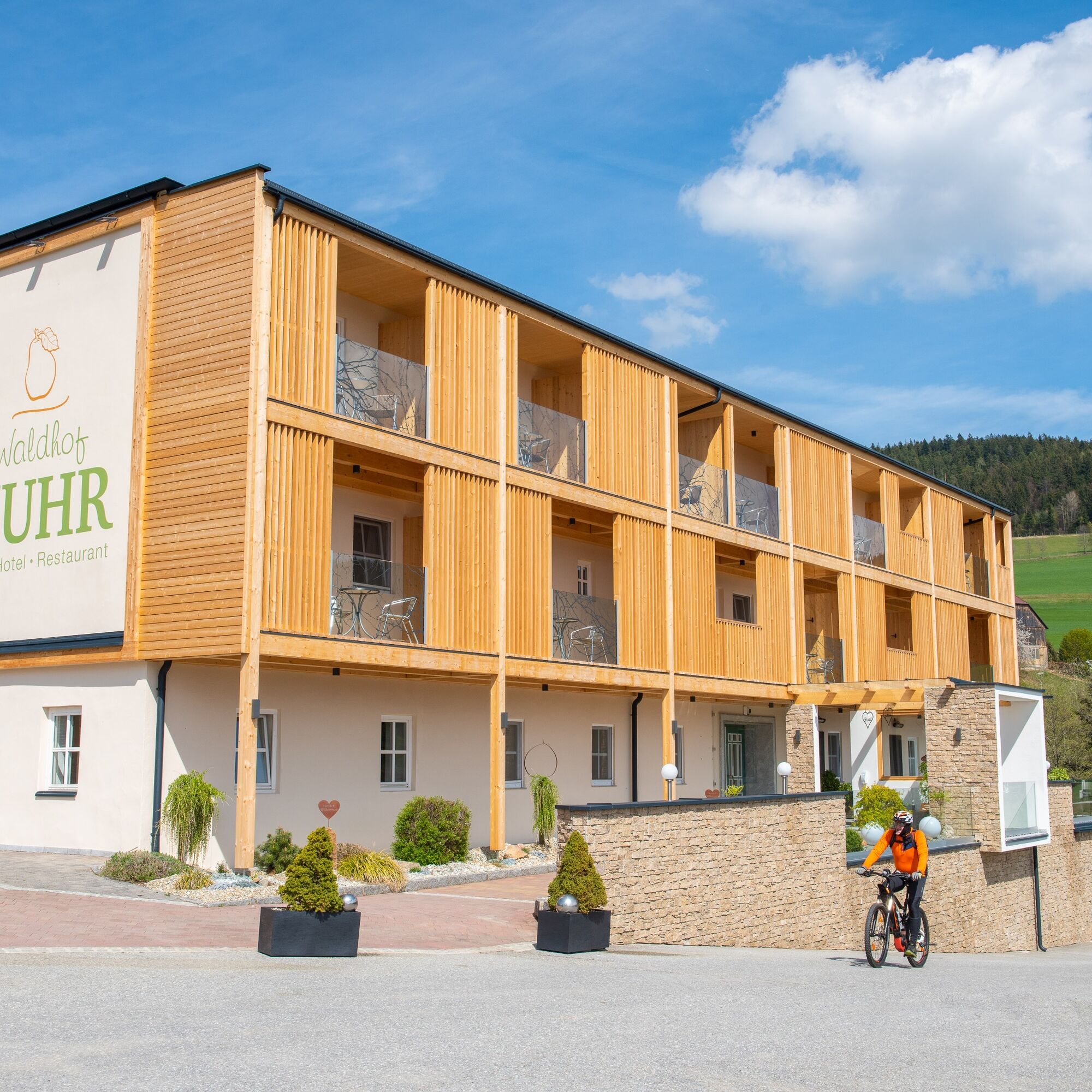
- Starting point
-
Pöllauberg, Hotel Muhr
- Route
-
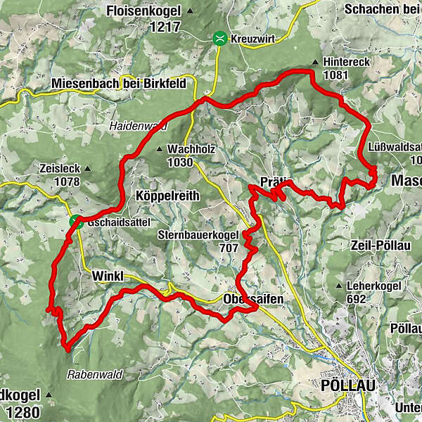
Hotel- Restaurant Muhr0.0 kmGashaus Derler18.2 kmWinkl18.6 kmObersaifen22.8 kmOberhochegg23.1 kmSternbauerkogel (707 m)25.5 kmPrätis28.8 kmKrughöf29.7 kmStraßhöf30.6 kmHotel- Restaurant Muhr32.5 km
- Best season
-
JanFebMarAprMayJunJulAugSepOctNovDec
- Description
-
It is advisable to pack appropriate provisions for this hike!Starting from the Hotel Muhr, we keep to the forest nature trail at the beginning, but soon leave it and reach the Zisser tavern. From here we continue via the Schloffereck, the Wolfgrube to the Gschaidsattel. From here we hike mostly down the valley to the former Hörting inn, cross the Prätis stream after a while, pass the Folklore Museum and now begin the last section of the hike back to the starting point at Waldhof Muhr.Congratulations on completing this extensive hike!
- Directions
-
Hotel Muhr - Zisser Taverne - Schloffereck
The forest nature trail, marked with yellow dots, begins behind the Hotel Muhr. This leads us first through the forest and then on a forest road past the Hirschalmhütte in approx. 45 minutes, climbing steadily to the Zisser Taverne. We walk past the large house for approx. 300 m in a northerly direction along the red-white-red marking no. 913 on the asphalt road, then turn left into a wooded area, walk through this and along the forest/meadow border until we reach a game reserve. We follow the white-green-white marked hiking trail no. 10 towards Schloffereck. We walk along the forest road past the barrier, first a little steeper and then slightly downhill to Sonnhofen house no. 46, vulgo Kogl-Luis. Once there, we take a look at the "landscape frame picture". Try to capture the most beautiful piece of landscape you can and take it home with you! There is also a bench here to treat yourself to a little refreshment or just to relax. The route continues along the Almerweg until we reach the Schloffereck after another 30 minutes.
Schloffereck - Wolfgrube - Gschaid-Sattel
Arriving at the Schloffereck, we first see the information board that welcomes us to the Pöllau Valley. However, we continue to the crossroads, keep left there, cross the road and hike on towards "Wolfgrube". This section of our hike is 2.3 km long. We walk along the nature park border, but we are in Miesenbach territory, which is why we do not come across our well-known and distinctive signposts here. When we arrive at the Wolfgrube, we are not confused by the signposts on site, which all lead to Miesenbach. However, we want to reach the Gschaid saddle, which is why we stay on our path and hike through a large meadow along a row of shrubs to the end of the meadow, where we find our red-white-red markings again. Once we reach the forest road, we head downhill and walk through the forest for about 15 minutes until we reach the Steinwänderweg path with a wayside shrine. We follow the asphalt road to the Gschaid saddle with its listed lime trees at 809 m above sea level.
Gschaid-Sattel - Stöss - Grottenstüberl
From the Gschaid saddle, our hike continues on the other side of the road in the direction of Pöllau, following the red-white-red markings no. 921 to the edge of the forest. From there, we turn right onto the forest path and continue through a forest. After a barrier we come to a field at approx. 1000 m above sea level, continue to the junction where the white-blue-white no. 2 markings come up, which we follow to the left in the direction of GH Derler. We leave the forest path and follow the white-blue-white marked forest road no. 2 downhill towards Pöllau. After leaving the forest, we continue our hike on an asphalt road. Once we reach the prominent tree (in the foreground a stone with the trail marker), we follow the Lehrhoferweg downhill to the next crossroads approx. 300 m away and then turn into the Kohlhoferweg, which takes us to the Winkl-Boden No. 30, Neuhäusler estate. We continue along a meadow path to the Winkl-Boden property no. 31, vulgo Kohlhofer. You have to see these beautifully maintained houses! Everything is beautifully preserved and the quaint fountain does the rest to make you fall in love with this place. After a brief refreshment, continue along the forest path towards the valley. After about 300 m you have to be careful, our path makes a 180° turn, we leave the forest road and continue along a forest path to a bench that invites us to "rest". From here we have a great view over the Pöllau valley. We continue past fruit trees until we reach the Winkl-Boden estate no. 35, vulgo Zenzl in Winkl. From here, we take the paved Spielstattweg towards the valley to the GH Derler and look forward to refreshments and refreshments. We reach the Grottenstüberl (former inn) via a forest path.
Grottenstüberl - Toni on the Wiesn - former GH Hörting
From the Grottenstüberl, the path leads behind the restaurant into the forest and then downhill on the asphalt road. After approx. 300 m you cross the Safenbach and turn left over the first narrow bridge and before the second bridge turn right at the stone wall to the detached house. Past the house, the next white-blue-white markings are at the garage, we cross a meadow into a wooded area with another bridge past a house and reach the Lackner farm. The path runs close to the bank of the stream and turns into an asphalt road. At a crossroads, the trail continues straight on through the next farm, Vulgo Stieger, into a small wooded area right next to the stream. Over bridges and stairs we reach the Obersaifen estate no. 83, Toni farm on the meadows. We continue in the direction of Pöllau/Sternbauerkogel along the white-yellow-white markings. The path follows a paved road over a bridge, slightly uphill, always following the markings past a bench into a wooded area. After the short ascent, we arrive directly at the former Hörting inn.
Former GH Hörting - Prätisgraben - turn-off for the Folklore Museum
At the former Hörting inn, we turn left onto the L448, Gschaiderstraße, and follow the white-yellow-white markings no. 4 in a northerly direction. After approx. 300 m, at the Bauernhofer sawmill, we come to a beautiful little chapel on the right-hand side. There we leave the road and follow the Bühlerweg past a small forest to the sports field of SV Union Saifen-Boden/Gschaid. Turn left up the sports field path, past a beautifully maintained wayside shrine and before the Sternbauer farm turn right up the field path to the two distinctive trees with our white-yellow-white markings. We follow the markings, enter the forest and cross the Sternbauerkogel. We continue downhill through the forest along the forest/meadow border until we reach a forest path and cross the L406 (Schloffereckstraße). The route leads us slightly uphill along the Geierweg to the Köppelreith estate no. 20, vulgo Hansl in der Grub, where a single tree with our markings shows us the way. We follow a meadow path to the bridge and through the forest to the Bachler farm landmark about 1 km away. Here we follow the Roseggerweg in a southerly direction and after about 10 minutes walk we come to the next fork in the path, the junction to the Folklore Museum or to Pöllau. On the left-hand side we see an old smelting furnace.
From the Folklore Museum - Hotel Muhr
We follow the white-yellow-white markings no. 4 through the forest, a somewhat steep ascent, then we reach the northern end of the Prätis settlement. We follow the Prätis settlement trail to the other end of the settlement, to the Prätis folklore museum, which is well worth a visit. After this very informative stopover, we continue to the Waldhof Muhr, which is still some distance away. We head north along the front of the folklore museum and leave the former "Römerweg" (now asphalt road) turning right at the end of the settlement near the sports field. A meadow path leads steeply downhill to the metal bridge over the Prätisbach stream and up again on the other side. We reach a property through an avenue of fruit trees via a field path, continue straight ahead at the yellow house (markings on the corner of the left-hand outbuilding!) over a small stream and come to an asphalt road. From here, we continue along the asphalt road for approx. 500 m until we turn right downhill at the crossroads and pass the "Franzl in der Strass" estate in Straßhöf. Immediately afterwards, we turn left onto the path into the Zeil. We walk along the steadily ascending path, past the Prätis farmstead no. 23, Kohl vulgo Stefan im Stoa, and after another 2 km we reach the Hotel Muhr via forest and meadow paths.
- Highest point
- 1,011 m
- Endpoint
-
Pöllauberg, Hotel Muhr
- Height profile
-

- Equipment
-
small rucksack with water bottle (+ provisions)
Sturdy shoes
Appropriate clothing - preferably several layers - "onion principle"
Rain and sun protection
Hiking poles as required
Mobile phone
Small first aid kit
Route description
Before starting the hike, check where you can stop for refreshments, including opening times, or pack suitable provisions. - Safety instructions
-
European emergency call: 112
Emergency call mountain rescue: 140 (if possible, please provide GPS data)
Rescue: 144
Fire brigade: 122 '
Police: 133
The trail is easy to walk and therefore suitable for the whole family.
Correct behaviour when hiking: Rules of behaviour when hiking
A few tips on correct and fair behaviour in the forest: (Source: Bundesforste https://www.bundesforste.at/english.html)
Hikers should avoid visiting the forest approx. 1.5 hours before sunrise and after sunset, as wild animals are particularly active at this time. Plastic bottles, handkerchiefs, cigarette butts etc. have no place in the forest! Please make sure that you do not leave any rubbish in the forest. Camping and making fires is strictly forbidden in the forest! In principle, every person in the forest is allowed to collect 2kg of mushrooms and berries per day for their own use. It is only prohibited if the forest owner expressly forbids it. In principle, every person in the forest is allowed to collect 2kg of mushrooms and berries per day for their own use. It is only prohibited if the forest owner expressly forbids it. - Tips
-
Experience the scenic diversity of the Pöllau Valley Nature Park
Plan enough time to enjoy the
culinary delights
- Additional information
-
Information about the region, places to stop for refreshments and overnight accommodation, excursion destinations etc. can be found here:
Tourism region Eastern Styria
Nature Park Pöllauer Valley office
Schloss 1, 8225 Pöllau, Austria
- Directions
-
Pöllauberg, Hotel Muhr
The Pöllau Valley Nature Park is located in the heart of Eastern Styria, the garden of Austria, approx. 60 km north-east of Graz and approx. 150 km south of Vienna
By car from Vienna
If you are driving from Vienna to Pöllau bei Hartberg, take the A2 towards Graz and drive about 110 kilometres until you reach the Hartberg exit. From there, follow the B54 in the direction of Pöllau.
By car from Graz
To get to Pöllau bei Hartberg from Graz, take the A2 motorway in the direction of Vienna. After about 30 kilometres, take the Gleisdorf West exit and then take the B54 towards Hartberg/Pöllau. Follow the B54 for about 25 kilometres until you reach Pöllau.
By car from Salzburg
To get to Pöllau bei Hartberg from Salzburg, take the A1 motorway towards Vienna. Drive about 110 kilometres to exit 109 (Salzburg junction). There change to the A9 motorway in the direction of Graz. At St. Michael, follow the S6 towards Kapfenberg. Continue on the S6 until the Krieglach exit. From there, take the B72 and then the L405 to Pöllau.
- Public transportation
- Parking


- Author
-
The tour Hotel Muhr: circular hike via Schloffereck and Gschaid is used by outdooractive.com provided.


General info
-
Oststeiermark
2126
-
Naturpark Pöllauer Tal
1095
-
Miesenbach bei Birkfeld
350