

- Brief description
-
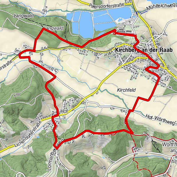
The Kirchbergvitalweg leads along forest and meadow paths, partially paved sidewalks and asphalt municipal roads.
- Difficulty
-
easy
- Rating
-
- Starting point
-
Alley by the school center
- Route
-
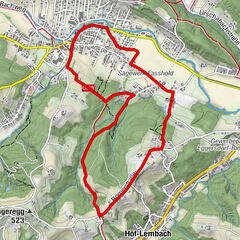
Kirchberg an der RaabHof3.4 kmJungberg4.1 kmGasthaus Rodler7.1 kmKirchberg an der Raab7.2 kmDie Prasserei7.2 kmPfarrkirche hl. Florian7.3 km
- Best season
-
JanFebMarAprMayJunJulAugSepOctNovDec
- Description
-
In Kirchberg it strikes thirteen! A young legend can be told about the renovation of the Kirchberg parish church: During the reworking of the dial on the tower clock, the error devil was at work. The journeymen painters who worked on the tower clock were known by the masons to be particularly snooty. They constantly harassed and ridiculed the apprentice masons who were diligently working on the church renovation. For a long time, the masons thought about how they could play a juicy trick on the painters. Without further ado, they decided to add another line to the twelve on the steeple, turning the twelve into thirteen. In order not to be seen during their prank, the apprentice bricklayers painted their stroke only when it was dark. It was not until the steeple-high scaffolding was taken down and the people of Kirchberg looked with interest and pride at their renovated church that the painters' outrage came to light: Since then, it has struck thirteen in Kirchberg!
- Directions
-
It is best to start in the avenue near the school center, where there is a large overview board with the hiking map and gymnastic exercises. After a few exercises to warm up the joints and muscles, we go along the pond path into the forest and then briefly uphill to the cross at the Schaffler family. Then continue along Langwaldweg until we branch off and join Kirchbergerstraße at Promitzerweg. We hike a short distance on a sidewalk and bike path and then turn into the Hof-Wörthweg, which we follow until we reach the Kricklerweg. From there we walk comfortably uphill on a meadow and forest path towards Harrachberg. Shortly through a hollow way down we reach the district Hof. We cross the Lichendorferstraße at the bus stop, walk uphill along the settlement path and reach a nice resting place above the Stocker family at the edge of the forest with a view of Kirchberg. The hiking trail now climbs slightly through a forest and joins the Lormanbergweg after a short meadow section. From there, the local circuit leads us down a bit until we turn into Jungbergweg. Soon we pass by the Lammer family (farmer's market every Friday in the village) and reach the farm of Obstbau Schuster with a stop and tasting of wonderful fruit juices and schnapps. If no one is home at the moment, you are welcome to help yourself from a refrigerator provided. Further on the path leads us directly to the Eicherlkreuz with a small chapel to stay. The Eicherlkreuz is along the Kirchbergvitalweg also the intersection of the Ortsrunde with the Bergrunde. We follow the local circuit and the Eicherlkreuzweg, which now runs through a hollow path in the forest for a short distance more steeply downhill and then joins the Hof-Wörthweg. The hiking route leads over a small bridge to the Kirchfeldweg, which we follow in the direction of Kirchberg. Before we reach the village center, it is worthwhile to pay a visit to the studio of the artists Anneliese and Ali Rauscher, who are known far beyond the borders of Kirchberg. Passing the community center, the hiker can really fortify himself in the nearby Gasthaus Rodler. In good weather, a beautiful terrace invites you to linger. Now it is only a short distance to the town center, which offers shopping opportunities and cozy cafes around the main square. A visit to the parish church is highly recommended. Past the castle, down the steep Hiegerriegel, we get back to the Schulweg and the starting point.
- Highest point
- 390 m
- Endpoint
-
Alley by the school center
- Height profile
-

- Equipment
-
Proper backpack packing makes many things easier: Pack heavy things first. The water bottle should always be within reach in a side pocket. All the things that are often needed, such as sunglasses, camera or hiking map, belong on top. An emergency kit, including blister plasters, belongs in every rucksack and it is always advisable to dress in layers.
- Safety instructions
-
Emergency call mountain rescue: 140
ambulance: 144
European emergency call: 112
firefighters: 122
police: 133Tips when reporting an emergency – Answer these six WH questions: What happened? How many people are injured? Where did the accident happen (are there GPS coordinates)? Who is reporting the incident (callback number)? When did the accident happen? What is the weather like at the site of the incident?
- Tips
-
Use the placed stones for stretching exercises to make the muscles elastic and the joints flexible.
- Additional information
- Directions
- Public transportation
-
Detailed information about arriving by ÖBB (Austrian Federal Railways) can be found at www.oebb.at or on the Verbundlinie Steiermark website www.busbahnbim.at
With Verbundlinie’s BusBahnBim route planner app, planning your journey has never been easier: simply enter towns and/or addresses, stop names or points of interest to check all bus, train and tram connections in Austria. The app is available free of charge for smartphones – on Google Play and in the App Store
- Parking
-
Parking available.


- Author
-
The tour Kirchbergvitalweg Ortsrunde is used by outdooractive.com provided.


General info
-
Oststeiermark
2126
-
Region Gleisdorf
1005
-
Kirchberg an der Raab
99