- Brief description
-
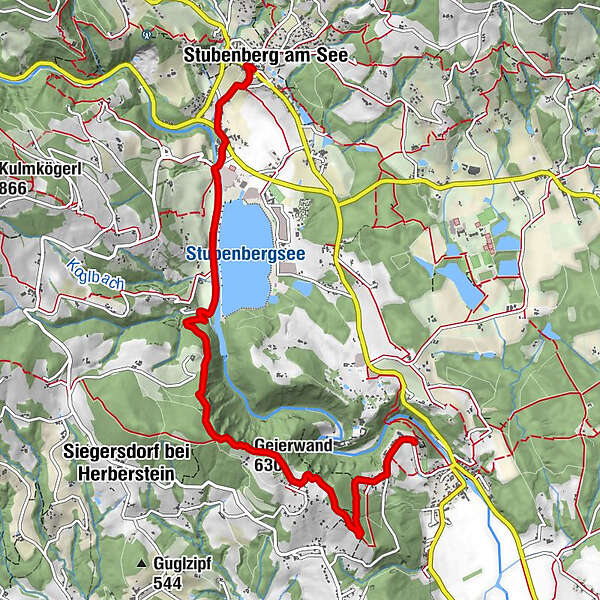
Hiking from the parish church of Stubenberg to the parish church of St. Johann bei Herberstein. For all those who love enjoyable hiking.Cultural tourism: sacred art and organ hiking
- Difficulty
-
medium
- Rating
-
- Starting point
-
Stubenberg parish church
- Route
-
Stubenberg am SeePfarrkirche hl. NikolausGeierwand (630 m)4.2 kmRosalienkapelle6.4 kmGasthaus Riegerbauer6.6 kmSt. Johann bei Herberstein6.9 km
- Best season
-
JanFebMarAprMayJunJulAugSepOctNovDec
- Description
-
We would like to invite you to combine your hike in ApfelLand-Stubenbergsee and the Pöllau Valley Nature Park with art and culture and culinary delights.
Download the free "Hearonymus" app, select "Churches in ApfelLand-Stubenbergsee and Pöllau Valley Nature Park" in the "Guides" section and your smartphone will become an audio guide. Churches and their organs and bells are presented and brought to life acoustically, so you can get to know the advantages of an individual tour with the sound of bells and organs.
The individual organ hiking tours can be easily combined with each other and can be walked in both directions, so that everything is possible, from a short hike to a long-distance hike.
- Directions
-
The hike begins at the Stubenberg parish church.First we walk along the "Seeweg" which leads us downhill past meadows and orchards to the Schmidbach. We follow this path to the main road, cross the road here and walk to the lakeside parking lot Strandbad / Feistritzbrücke. After the bridge, we follow the right bank of the Feistritz to the former Waldhof.
Now it really gets going, as the path climbs steeply from here, leading us exclusively through a beautiful mixed forest until we reach the highest point of the Geierwand.
Once we reach the highest point, we are rewarded with a breathtaking view of Lake Stubenberg and the surrounding area. After a short rest, which we have earned, we continue. The descent initially runs along the edge of the forest and then continues across meadows, past farmsteads and through a short section of forest to the Heinrichhöhe/ Kranzl vantage point, from where we have a unique view of Herberstein Castle (this bird's eye view is only reserved for hard-working hikers). After this fantastic impression of this imposing building, we continue to the "Holy Sepulchre".
There are three chapels on this beautiful square. This is a quiet, beautiful place that invites you to linger. From here, the route continues steadily downhill, where we are accompanied by Stations of the Cross leading through a beech forest, the dimensions of which leave us in awe. After leaving the forest, we pass the Rosalia Chapel on the outskirts of St. Johann bei Herberstein and then walk a little further until we reach the parish church of St. Johann bei Herberstein.
- Highest point
- 636 m
- Endpoint
-
Parish church of St. Johann near Herberstein
- Height profile
-

- Equipment
-
Small rucksack with water bottle (+ provisions)
Sturdy shoes
Appropriate clothing - preferably several layers - "onion principle"
Rain and sun protection
Hiking poles as required
Cell phone
Small first aid kit
Route descriptionBefore starting the hike, check where you can stop for refreshments, including opening times, or pack suitable food and drink.
- Safety instructions
-
Important telephone numbers:
European emergency call: 112
Emergency call mountain rescue: 140 (if possible, please provide GPS data)
Rescue: 144
Fire department: 122
Police: 133
Here you will find the rules of conduct for "Safe handling of grazing livestock" and "Safety on the mountain"
A few tips on correct and fair behavior in the forest: (Source: www.bundesforste.at
Hikers should avoid visiting the forest approx. 1.5 hours before sunrise and after sunset, as wild animals are particularly active at this time.Plastic bottles, handkerchiefs, cigarette butts etc. have no place in the forest! Please make sure that you do not leave any garbage in the forest.Camping and making fires is strictly forbidden in the forest!In principle, every person in the forest is allowed to collect 2 kg of mushrooms and berries per day for their own use. It is only prohibited if the forest owner expressly forbids it.
- Tips
-
Cultural treasures in ApfelLand-StubenbergseeCulinary delights in ApfelLand-Stubenbergsee
- Additional information
- Directions
-
ApfelLand is located in the heart of Eastern Styria, approx. 60 km north-east of Graz and approx. 140 km south of Vienna
By car: Coming from Vienna: Take the Südautobahn (A2) to the Hartberg exit - via Bundesstraße (B54) towards Graz - 2 km after Kaindorf towards Graz, turn off towards ApfelLand-Stubenbergsee- Stubenbergsee
Coming from Salzburg/Germany: Take the highway via Salzburg - Pyhrnautobahn (A9) to Graz - continue via the Südautobahn in the direction of Vienna (A2) to the Gleisdorf West exit - federal road (B54) to Kaibing - ApfelLand-Stubenbergsee- Stubenbergsee
- Public transportation
- Parking


-

-
AuthorThe tour Organ Hiking: Stage Stubenberg - St. Johann bei Herberstein is used by outdooractive.com provided.


-
Oststeiermark
2126
-
ApfelLand - Stubenbergsee
1140
-
Stubenberg am See
321