
- Brief description
- Difficulty
-
easy
- Rating
-
- Starting point
-
Parking lot directly at Gasthof Mooswirt (888 m)
- Route
-
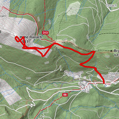
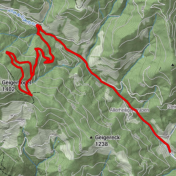
Mooswirt0.0 kmAllerheiligengraben0.7 kmAllerheiligengraben9.8 kmMooswirt10.7 km
- Best season
-
AugSepOctNovDecJanFebMarAprMayJunJul
- Description
-
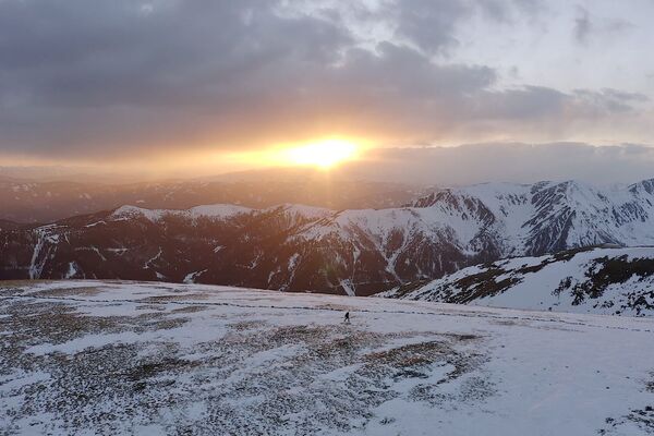
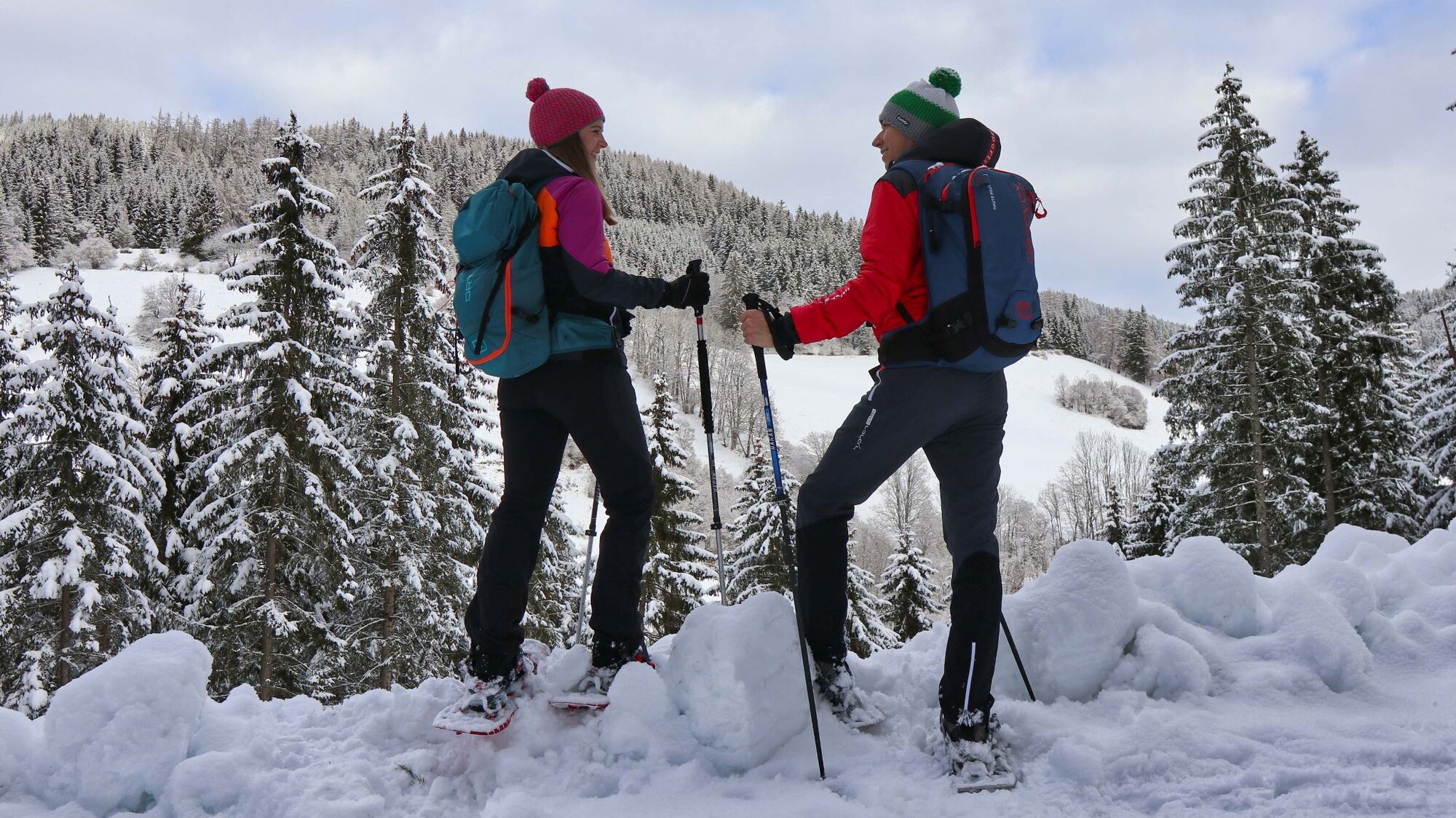
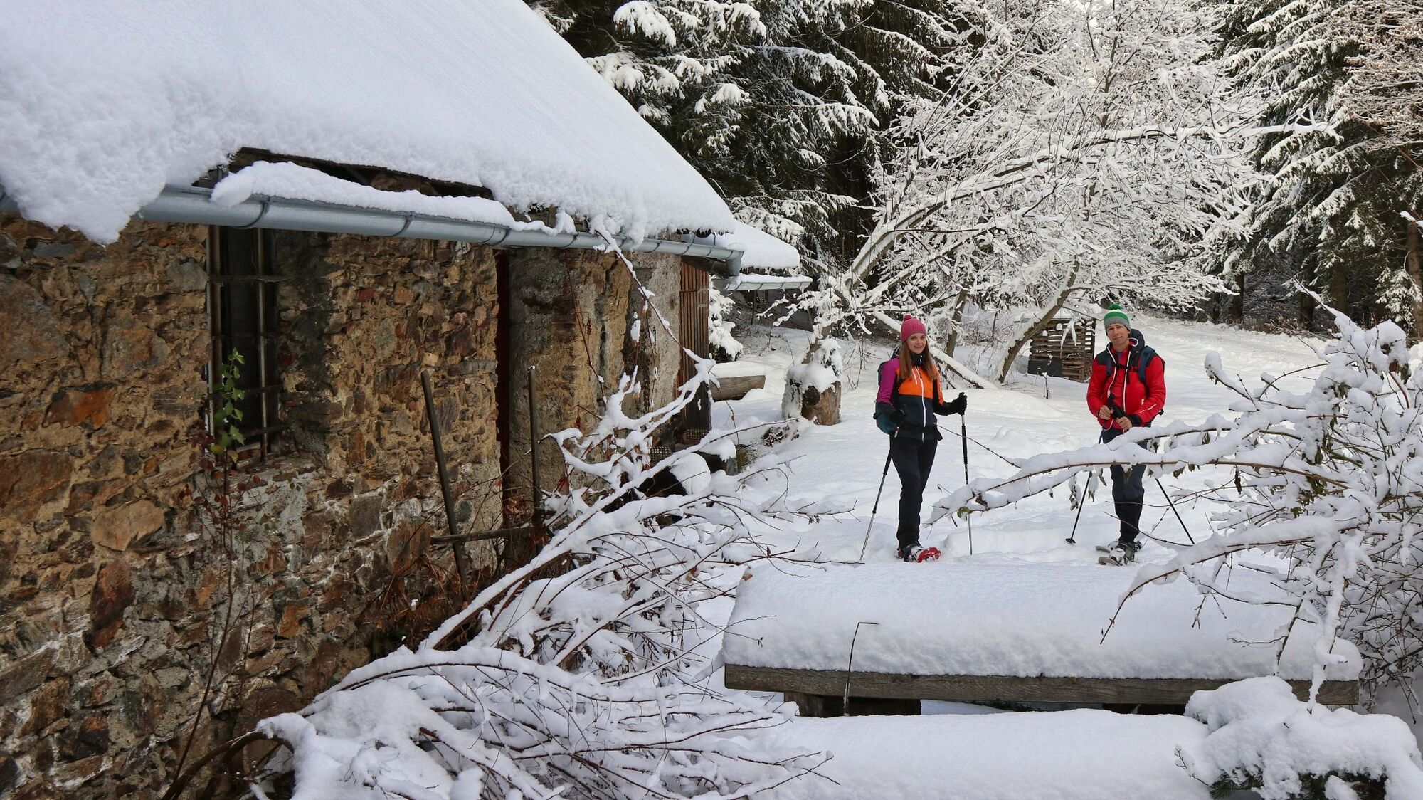
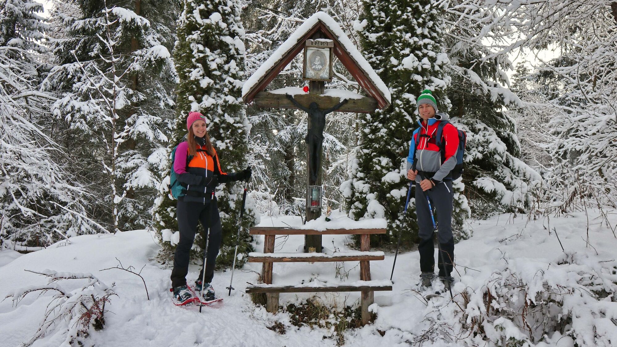
There are numerous and comfortable local recreation and hiking trails north of the town of Fohnsdorf on the Gaaler Höhenzug in the Murtal adventure region. These trails are popular in summer and winter and yet you are sometimes very lonely on the road. The interesting thing about the Gaaler Höhenzug, which is located to the south of the Seckau Alps, is the snow and weather influences from the north and the branched valley forms. The last winters you could find beautiful tours here, because the snow in the shady areas has kept for a long time. One of these hikes leads through the Allerheiligengraben to the wayside cross "Schwarzer Herrgott". Elfi Lukas describes in the book Von Schloss zu Schloss (From Castle to Castle): "When lightning once struck the wayside cross, the statue of Christ turned black but did not burn. It has survived through several generations." The hike is mainly on forest roads and is perfect for pleasure hikers and beginners. On the one hand, orientation is easy, even if markings are missing here and there, and on the other hand, the climbs are mostly leisurely and therefore easier on your strength. This forest snowshoe tour allows in between beautiful views of the opposite slopes of the Gaaler Höhenzug. If you take a closer look at the surroundings, you will notice the dilapidated huts, which have something mystical about them and reveal the agricultural structures from times long past.
- Directions
-
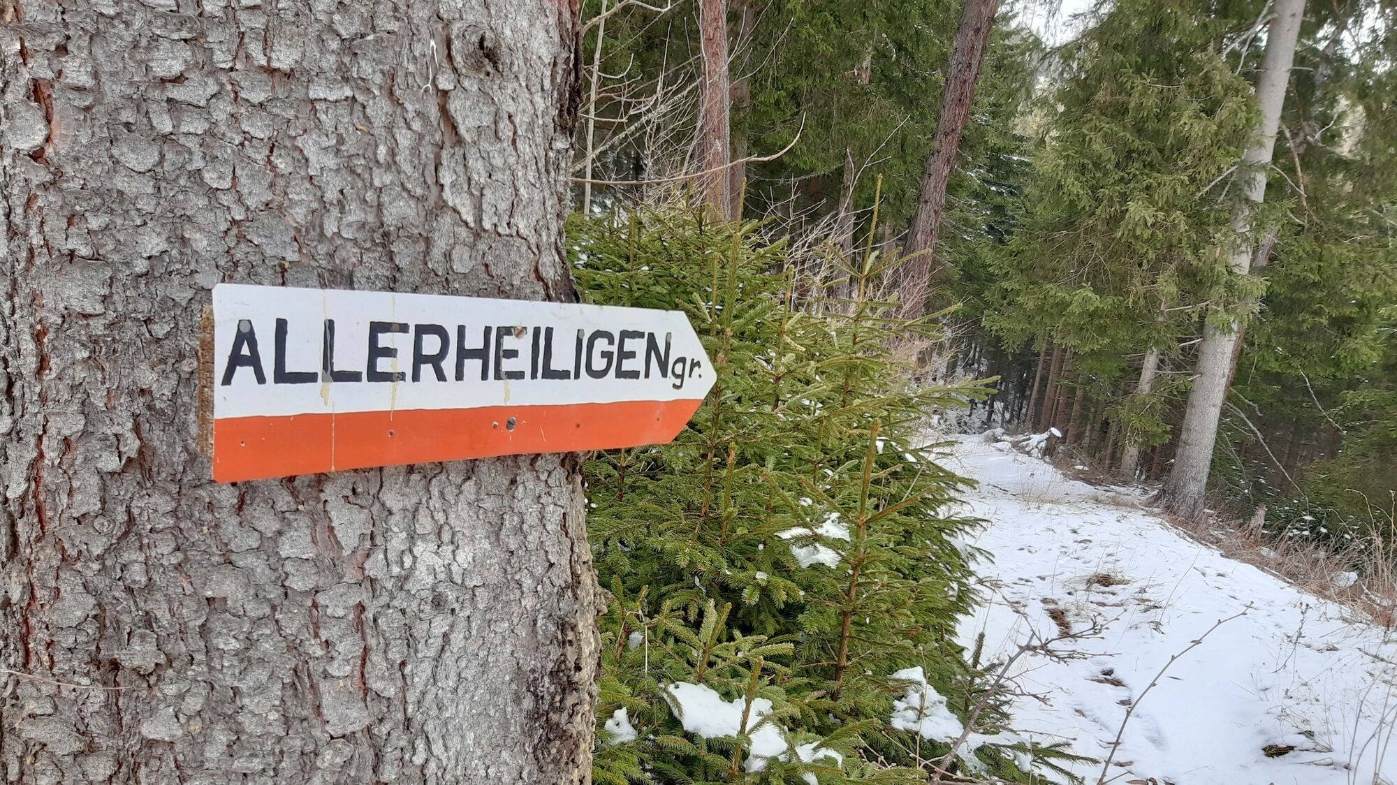
We walk from the Mooswirt inn (1), 888 m, up the road slightly uphill along the Allerheiligengraben. We follow the main path - again and again side roads lead away - and after about 2.7 km we see a prominent, wooden signpost (2), 1080 m, on the left side. Here the distances to the Gasthof Mooswirt and to our destination, the Schwarzer Herrgott, are indicated in kilometers. For orientation, the trail number 10 and the mountain bike route "Himmelbauer Tour" should also be mentioned. At this sign, a side road now leaves to the left, which we now follow. Immediately we cross a bridge and then continue moderately uphill, always following the forest road. After a while we come to a small clearing where there is a stone house with a wooden annexe, the Ertlhube (3), 1220 m. After the Ertlhube, the forest road makes a right turn, where the hiking trail leads uphill on the left (we come down here on the descent). We stay on the forest road during the ascent and can thus take a contemplative and partly panoramic path. Before we reach our destination, the forest road leads even slightly downhill and then we see the wayside cross with the name Schwarzer Herrgott (4), 1270 m, in a crossing area. The descent is via the now shorter hiking trail back to Ertlhube (3), 1220 m, and then we follow the already known ascent route.
- Highest point
- 1,289 m
- Endpoint
-
Parking lot directly at Gasthof Mooswirt (888 m)
- Height profile
-

- Equipment
-
Apart from the most necessary equipment, such as snowshoes, poles, etc., we recommend that you bring orientation aids (bus pole, map, GPS), avalanche transceiver, probe and shovel. We have taken this checklist from the Rother Snowshoe Guide Styria and summarized it for you, so that it will be helpful for your next snowshoe hike.
SnowshoesTelescopic poles with snow plateWaterproof mountain boots or lined winter mountain bootsBackpack: If the snowshoes have to be carried, a backpack with a lid buckle is necessary.Gloves: waterproof and warmingHeadgearGaiters: If there are no closable leg cuffs on the pants.Pants: Ski pants are rather not recommended because they are often too warm, but we need waterproof and warming pants.Warming outerwear: Onion layering system, t-shirt, sweater, jacket and winter jacket with hood.Sunglasses: Very important, as snow reflects up to 95% of the light.Creams: Protective measures for the skin are important against both the sun and the cold.Headlamp: In winter it gets dark early, especially in the forest it can often be very dark when dusk begins.Thermos: On cooler days a warming drink is pleasant.Snack or snackFirst aid kit
Other important equipment
Cell phoneTour descriptionMap: For overview a map in scale 1:50.000 of the respective region and a detailed plan of the hikeGPS deviceAvalanche transceiver (avalanche transceiver), shovel and probe
- Safety instructions
-
When choosing a snowshoe tour, weather, snow and avalanche situation are essential criteria. Basically, the decision of the tour depends on your own experience and basic physical condition. In advance, factors such as weather, avalanche situation report and equipment must be clarified in detail. A clear description of how to prepare for a snowshoe hike can be found in the Rother Snowshoe Guide Styria from page 14 to 20. Even if you have prepared perfectly, you must also take into account the given weather and snow conditions and the physical condition of the day during the hike itself. Thus, there is one important basic rule: please turn around if the hike becomes too strenuous or if the external conditions require it.
Walking times: The indicated walking time is to be understood as a guideline, as it depends on the snow conditions, the terrain and the presence of a trail. The individual condition and the stamina for strenuous trail work also play an important role. Sometimes the duration of the tour can change significantly due to large amounts of new snow, broken slush, soft sulzing snow, etc.
Alpine emergency call:
Mountain rescue emergency number: 140
EU emergency number: 112
Avalanche info:
Weather service:
Direct link mountain weather Styria:
https://www.zamg.ac.at/cms/de/wetter/produkte-und-services/bergwetter/steiermark
- Tips
-
Another hike on the Gaaler Höhenzug can be found in the snowshoe guide Styria under tour 16 "Hölzelkogel".
- Additional information
- Directions
-
From Judenburg via state roads to the Allerheiligengraben (11 km, approx. 20 minutes).
From St. Michael in Upper Styria via the Murtal expressway S36 (vignette required) to Fohnsdorf (36 km, approx. 25 minutes) and on to Allerheiligengraben (45 km in total, approx. 35 minutes).
With the car to the snowshoe hiking - a few things you should pay attention to!
Good winter tires are an absolute MUST!Ice scraper, snow broom, de-icer for the door locks and a small shovel belong to the basic equipment.Put snow chains and a tow rope in the car, even if you are not good with them yourself. Helping and knowledgeable hikers are always available on the mountain!Clear the car completely of snow and ice, especially sweep off the roof of the car completely.When parking, make sure you leave room for other motorists.Always park so that the rest of the roadway remains clear for cars, logging trucks, and snow removal vehicles.Find out about the snow situation on the access road or parking facilities before setting off. (hut host, webcams)
- Public transportation
- Parking
-
Parking directly at the Gasthof Mooswirt.


- Author
-
The tour Easy snowshoe hike to the schwarzer Herrgott is used by outdooractive.com provided.