- Brief description
-
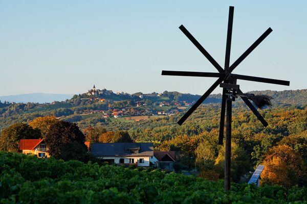
Family-friendly, flat route; leads past the golf course in Gillersdorf to beautiful river landscapes and past mills that give the tour its name.
- Difficulty
-
medium
- Rating
-
- Starting point
-
Spa Loipersdorf
- Route
-
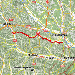
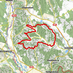
Lauten0.4 kmHirczy-Kapelle1.8 kmGillersdorf3.3 kmRudersdorf10.6 kmMamarossa14.4 kmPfarrkirche Loipersdorf20.7 kmGasthof Jandl20.7 kmBad Loipersdorf20.7 kmDornfeld23.1 kmDornegg26.2 km
- Best season
-
JanFebMarAprMayJunJulAugSepOctNovDec
- Description
-
The route leads past the golf course in Gillersdorf to beautiful - still untouched - river landscapes of the Feistritz, Lafnitz and Rittschein. The route also leads past mills; even though flour is no longer milled, they have lost none of their fascination as "contemporary witnesses" together with the imposing weirs.
- Directions
-
After the start at the spa forecourt, turn right along the spa access road for approx. 100 m until you reach the intersection. Here turn right in the direction of Gillersdorf /Golfplatz. After approx. 200 m keep left towards Oberhenndorf. After approx. 1 km you come to a fork in the road at the Hirczy Chapel, before this turn left. From here it goes 1 km partly with a steep incline into the village of Gillersdorf. In the center of the village keep left and after 100 m turn right into the access road to the golf course. After passing the golf course, you will see a farm on the left and leave the asphalt road. Here you cross at the weir of the so-called. Dobersdorfer Mühle (also called Bagdy Mühle) and passes the border between Styria and Burgenland. Past the mill site and across the spillway, follow the gravel road and after about 300 m turn left. Here we are already in the area of the Lafnitz and ride comfortably upstream to Rudersdorf. After the premises of the Katzbeck company, turn left to the Fritz Mühle mill. After the mill building we cross the Lafnitz on an old wooden bridge and continue towards Fürstenfeld. Passing the Hansl ponds (stay left here) you can already see the somewhat higher lying parts of the town. After about 500 m you cross the Feistritz again and then cycle through the district of Mühlbreiten in the direction of Übersbach. Before that, you cross the state road in the area of the Pestkreuz. In the forest before Übersbach you turn left in the direction of Pöltl Mühle. Here you cross the Rittschein and cycle upstream on the right for about 1 km. Then you come to an asphalt road and meet the R 21/Rittscheintalradweg. Turn left here and follow the road and the signs until you reach the town of Bad Loipersdorf after about 3 km. In the center you pass the kindergarten and the elementary school and leave the town again until after about 1 1/2 km you turn right at the gas station in the direction of Stein. From here you use the cycle path that runs parallel to and partly off the road until you turn left towards the spa shortly before you reach Stein. After the comfortable climb on the municipal road, it is then only flat via Dornegg back to the starting point Therme.
- Highest point
- 362 m
- Endpoint
-
Spa Loipersdorf
- Height profile
-

- Equipment
-
Touring bikes or city bikes are recommended. Tip: A basic equipment of tools and accessories such as spare inner tube and/or repair kit, spanner, air pump, brake and shift cable as well as a screwdriver can never hurt.
- Safety instructions
-
Partial traffic on the roads as well as oncoming hikers. Use at your own risk.
Ambulance: 144
European emergency call: 112
Firefighters: 122
Police: 133Tips when reporting an emergency – Answer these six WH questions:
What happened?
How many people are injured?
Where did the accident happen (are there GPS coordinates)? Who is reporting the incident (callback number)?
When did the accident happen?
What is the weather like at the site of the incident? - Tips
-
-Impressive unspoiled river landscape.
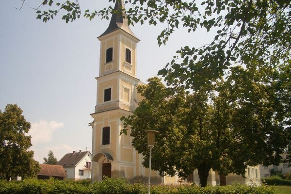
-Fritz Mill in Rudersdorf: Grain mill built at the beginning of the 19th century on the premises of which an oil press is still in operation today (opening hours: Mon-Fri 6:00-13:30) - Additional information
- Directions
-
FROM VIENNA & LOWER AUSTRIA
By car: South freeway (A2) to exit Ilz/Fürstenfeld. From here via Fürstenfeld bypass to Bad Loipersdorf.
FROM GRAZBy car: on the A2 motorway in the direction of Vienna as far as the Ilz/Fürstenfeld exit. From here via Fürstenfeld bypass to Bad Loipersdorf.
FROM WESTERN AUSTRIA AND BAVARIA
By car: via Salzburg on the Phyrn freeway (A9) and the Süd freeway (A2) or via Carinthia on the Süd freeway (A2) to the Ilz/Fürstenfeld exit. From here via Fürstenfeld bypass to Bad Loipersdorf.
FROM ITALY OR SLOVENIA
By car: via Villach on the southern freeway (A2) to the exit Ilz - Fürstenfeld - Bad Loipersdorf or via Maribor on the Phyrn freeway (A9) and the southern freeway (A2) in the direction of Vienna to the exit Ilz/Fürstenfeld. From here via Fürstenfeld bypass to Bad Loipersdorf.
- Public transportation
-
Detailed information about arriving by ÖBB (Austrian Federal Railways) can be found at www.oebb.at or on the Verbundlinie Steiermark website www.busbahnbim.at
With Verbundlinie’s BusBahnBim route planner app, planning your journey has never been easier: simply enter towns and/or addresses, stop names or points of interest to check all bus, train and tram connections in Austria. The app is available free of charge for smartphones – on Google Play and in the App Store
- Parking


-

-
AuthorThe tour FF 14 - Mill tour (Mühlentour) is used by outdooractive.com provided.