© Tom Lamm | ikarus.cc - Tom Lamm
Tour data
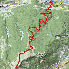
13.18km
815
- 1,050m
300hm
01:30h
- Brief description
-
Beginner's tour on asphalt - climbs up to 10%, 8.8km of little used municipal roads - 4.2km of moderately used state road.
- Difficulty
-
easy
- Rating
-
- Starting point
-
Information office Murau
Signage: Bike 2 - Route
-
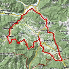
Filialkirche hl. Anna0.1 kmDiamantweg Zentrum der Karma Kagyü Linie0.4 kmMurau (829 m)0.6 kmWimml2.7 kmLaßnitzbach10.3 kmMurau (829 m)12.9 km
- Best season
-
JanFebMarAprMayJunJulAugSepOctNovDec
- Description
-
Information office Murau - Stolzalpen traffic circle direction Scheifling - at the next traffic circle turn right approx. 200 m direction St.Lambrecht - after the Mur bridge turn left - after the
after the railroad crossing turn left - Laßnitzbach - Wirt am Stein - crossroads Joslbauer turn right - vlg. Döller after 200 m at the crossing straight on - Probster Graben - vlg. Moser highest point of the tour 1050 m - crossing vlg. Lindner right off - junction to the state road right off - Monsbergkreuz - Murau. - Highest point
- 1,050 m
- Ticket material
GPS Downloads


Surfaces
Asphalt
Gravel
Forest
Mountain paths
Single trails
Trial
Traffic
Other tours in the regions