


- Difficulty level
- C/D

- Brief description
-
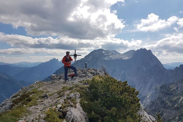
Pfaffenstein, western Hochschwab
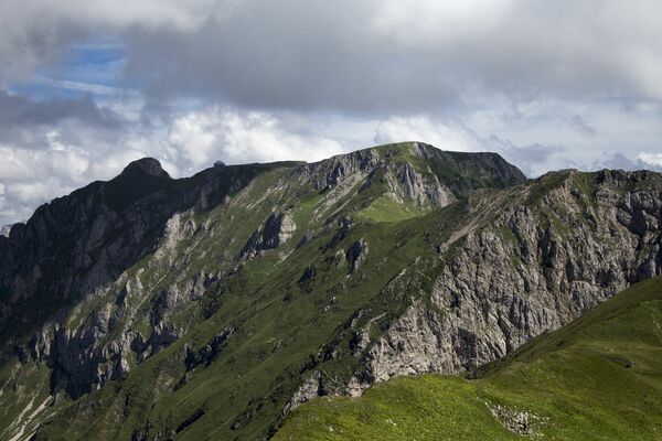
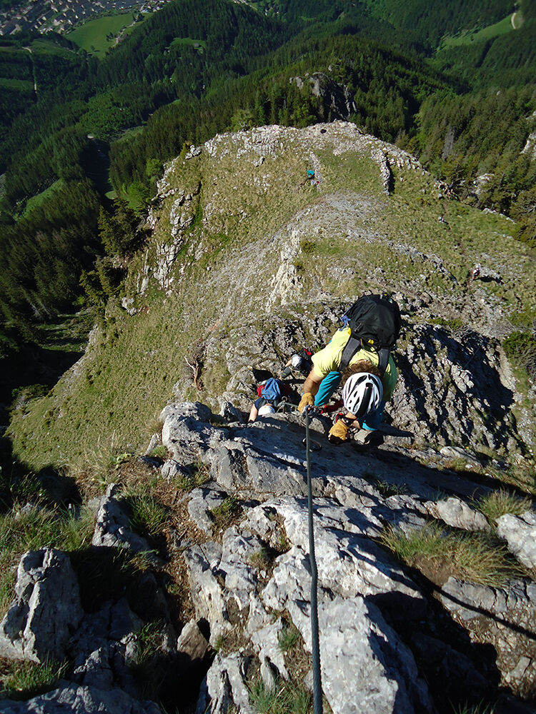
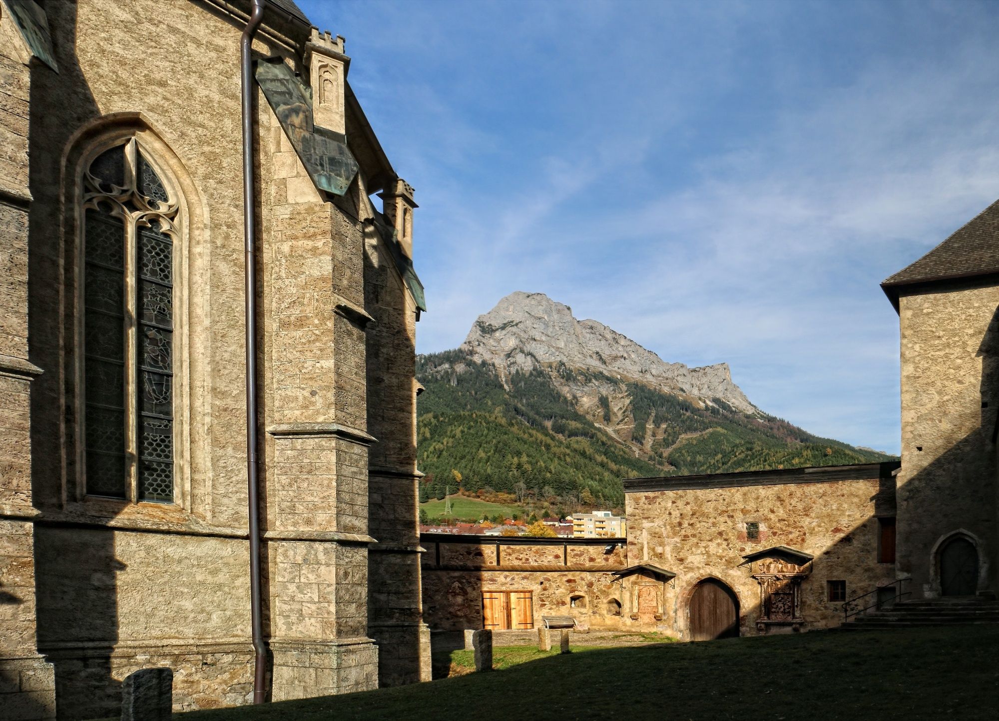
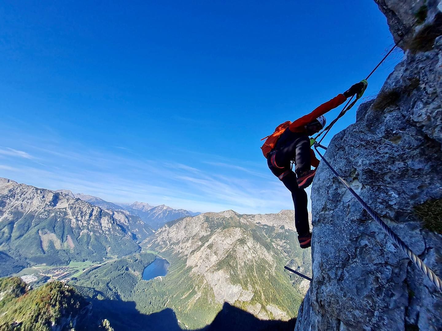
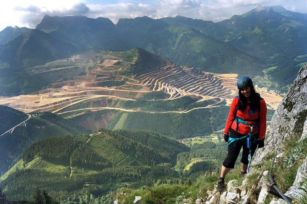
Along the entire via ferrata you can enjoy a magnificent view of the Erzberg, Lake Leopoldstein and the town of Eisenerz. Tough, strenuous and exposed sections make the via ferrata a very special climbing experience.
The trail was opened in 2005 and leads to the summit on a beautiful route. It was built for the 100th anniversary of the Naturfreunde Eisenerz. The Eisenerzer Steig is located in the ERZBERG LEOBEN region.
- Difficulty
-
difficultDifficulty level C/D
- Rating
-
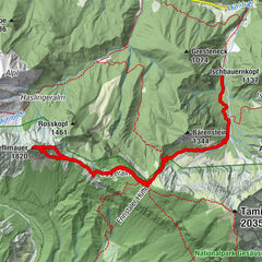
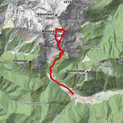
- Starting point
-
Pfaffenstein parking lot (near the power line)
- Route
-
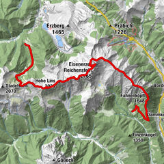
EisenerzEisenerz7.4 km
- Best season
-
JanFebMarAprMayJunJulAugSepOctNovDec
- Description
-
Ascent: 1,5-2 hrs, 750 HMFrom the parking lot follow the gravel path up to the edge of the forest. Follow the markings to the fork Markussteig /825) / Südwandsteig (Schrabachersteig) (826). Follow the path (825) to the left and walk steeply uphill through the high forest in serpentines, crossing several forest roads and reaching the first rocks of the Kessel wall. Following the markings, you reach a rock niche with memorial plaques via a small saddle. "Here it goes right to the entrance"
Course: 1,5 hours approx. 300 HM
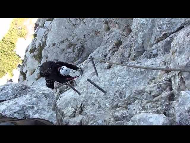
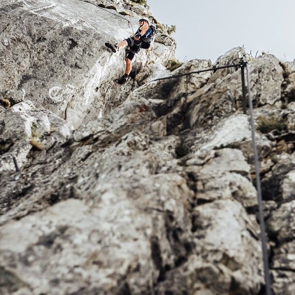
The entry starts with C and continues over the "Petergstammplatte" to the helicopter landing site, where there is the first escape possibility (left). Along the wet ridge to the west ridge shoulder - there you have the second exit possibility - and after a short traverse you come to the ramp. The penultimate section is very exposed and exhausting. Finally, you climb through the chimney to the Blockverschneidung D.
Descent: 3 hours 1050 HMFollow the well-marked and partially secured (A and A/B) Markussteig (normal route) back to the start and starting point.
- Highest point
- 1,835 m
- Endpoint
-
Pfaffenstein parking lot (near the power line)
- Exposition
- Height profile
-

- Equipment
-
Buy your equipment in a "mountain sports store" (professional advice).combi harness (chest and seat harness) or hip belt, via ferrata set with additional loop (lazybones) and easy-to-use carabiners (sample the different models in the store or at the course), rockfall helmet, gloves, suitable mountain boots (also for access and descent on snow and ice), 2 rep cords, reserve clothing, food and plenty of drinks.
The most important things in summary:
Alpine equipment with precautions for weather changes (clothing, gloves, headgear, etc.), maps and topo
Climbing harness with via ferrata set
climbing helmet
adequate footwear
via ferrata gloves
- Safety instructions
-
Very difficult, mostly between B and C, several passages C/D and D, combined with partly great exposure.
Very well suited as an introduction to the extreme via ferrata world!
In wet conditions the via ferrata is not recommended because of the earthy walking passages.
Before your first via ferrata tour, it is essential that you complete an alpine training course (if possible already with your own equipment). These courses are offered by mountain guides, alpine schools and alpine clubs (e.g. Alpenverein, Naturfreunde, etc.).
- Tips
-
We recommend a visit to the Styrian Erzberg!
Erzberg is a world of its own: With Adventure Erzberg, visitors experience pure Erzberg feeling during the adventure ride with the Hauly in the active open pit mine, in the underground adventure world show mine, during the Thursday live blasting and in the brand new open-air exhibition Erzberg Erlebnisreich. Visitors can immerse themselves in Austria's lively mining industry and experience the everyday work of real miners in the largest open pit mine in Central Europe.
www.abenteuer-erzberg.at
Phone: +43 3848 3200
- Additional information
- Directions
-
Arrival by car
From the west: Munich - Salzburg - (A10) Tauernautobahn - B99 to Radstadt - Ennstalbundesstraße to Liezen - (A9) Pyhrnautobahn - exit Traboch - B115 Eisenbundesstraße to Radmer; Eisenerz and Vordernberg or via the Gesäusebundesstraße from Admont - Radmer - Eisenerz - Vordernberg
From the east: Vienna (A2) - at Neunkirchen towards Semmering (S6) - Leoben - St. Michael junction - Traboch exit - B115 Eisenbundesstraße to Vordernberg - Eisenerz - Radmer
From the south-east: Graz - (A9) Pyhrnautobahn - Gleinalmtunnel (toll) - St. Michael junction - Traboch exit - B115 Eisenbundesstraße to Vordernberg - Eisenerz - Radmer
From the south: Südautobahn (A2) to Bad St. Leonhard - Obdach - Zeltweg - Murtal Schnellstraße - Knoten St. Michael - Abfahrt Traboch - B115 Eisenbundesstraße to Präbichl
From the north: Linz - (A9) Pyhrnautobahn - Traboch exit - B115 Eisenbundesstraße to Vordernberg - Eisenerz - Radmer or via the Gesäusebundesstraße Admont - Radmer - Eisenerz - Vordernberg.
- Public transportation
-
Timetables and travel information can be found directly at: Österreichischen Bundesbahnen(ÖBB), Steiermärkischen Landesbahnen (STLB), www.busbahnbim.at
With the BusBahnBim app of the Verbundlinie, timetable information has never been easier: all bus, train and tram connections in Austria can be queried by entering locations and/or addresses, stops or important points. The app is available as a free app for smartphones (Android, iOS) - on Google Play and in the
- Parking
-
Parking lot Pfaffenstein
On the B 115 to Eisenerz, at the police to the right always uphill to the end of the driving possibility to the parking lot with panorama board

- Author
-
The tour Eisenerzer Steig is used by outdooractive.com provided.


General info
-
Erzberg Leoben
39
-
Hochschwab
22
-
Eisenerz
15