- Brief description
-
A panoramic tour over the "Rote Alm", the Zirbitzkogel in the Seetaler Alps.
The 3-day tour leads from the Tonnerhütte over hiking trails and paths with magnificent panoramic views past mountain lakes and rustic huts. The long-distance hiking trail winds between Styria and Carinthia through fascinating stone pine forests and over a world a flowers and herbs that already fascinated the Celts and Romans.
- Difficulty
-
medium
- Rating
-
- Starting point
-
Stoanahütte
- Route
-
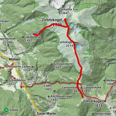
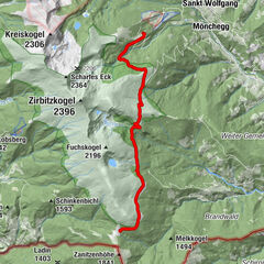
Stoanahütte0.0 kmZirbitzkogel (2,396 m)6.1 kmZirbitzkogel Schutzhaus6.1 km
- Best season
-
JanFebMarAprMayJunJulAugSepOctNovDec
- Description
-
Day 3: From the Stoanahütte you return to the Schneid via the hiking trail. With the Zirbitzkogel always in view, you hike with breathtaking views all the way to the Lavanthöhe (view of the Lavantsee lake and the Murtal valley). The Helmuth Earth shelter on the Zirbitzkogel offers a stop for refreshments. From there you start the descent to the forest border and finally across the ski slope to the Tonnerhütte.
- Directions
-
The 3rd stage starts at the Stoanahütte. From there we climb from the Judenburgerkreuz following the trail markings, 308, or 312 in the direction of Zirbitzkogel steeper uphill.
The "Frischnschwemm" is a somewhat strenous section, which can be overcome well with a few swtichbacks. We reach, following the markings to the Wildseeblick - a popular resting place. From here it goes slightly uphill to the Fuchskogel (2.214m), photogenic cairn, oversizes summit cross. Along the broad ridge we follow the long-distance hiking trail 308 to the "Murtalblick" (2.240m). On the section of the trail, from around mid-July, we are constantly accompanied by the scent of fresh Speik . From here the landscape grants us a deep view of the Lavantsee (origin of the Carinthian Lavant) and to the glacier grindings.
Now we cross northeastward slightly downhill to the ÖTK monument (pyramid of quartz blocks) above the Lavantsee and then straight somewhat steeper uphill, via the supply path to the "Helmut-Erd-Schutzhaus" on the Zirbitzkogel (2.376m). After a "refreshment" any signs of fatigue are overcome. Strengthened, you reach the Zirbitzkogel summit (2.396m), which is within reach. A large panorama stone facilitates the determination of the surrounding mountain landscape (360 degree panorama).
We now descend in a westerly direction, preferably during the evening atmosphere. overlooking almost the entire nature park region. The "Weite Alm" in front of us is glowing red. From the summit, we first descend soutward to the "Murtalblick", then westward downhill past the spring known as the "Wanderertränke", to the "Herter Höhe" and finally back to the Tonnerhütte.
- Highest point
- 2,374 m
- Endpoint
-
Tonnerhütte
- Height profile
-

- Equipment
-
Good footwear
Sun protection
Sufficient food - Tips
-
Alternative away from the St. Martiner Hütte: 12.3 km | 670 vertical meters ascending | 778 vertical meters descending
- Additional information
-
The ideal time for this tour is from May to October.
- Directions
-
Coming from Judenburg via Unzmarkt to Scheifling. Continue straight on until you reach Neumarkt. In Neumarkt keep left and drive via Mühlen to the Tonnerhütte.
Coming from Tamsweg drive via Ranten (or Stadl an der Mur) to Murau. Keep right here and drive via Laßnitz, St. Lambrecht and Mariahof to Neumarkt. Keep left here and drive via Mühlen to the Tonnerhütte.
- Public transportation
-
With the BusBahmBim app for the Verbundlinie, timetable information has never been easier: all bus, train and streetcar connections in Austria can be queried by entering locations and/or addresses, stops or important points. The app is available as a free app for smartphones (Android, iOS) - on Google Play and in the App Store.
- Parking
-
On arrival, parking is possible at the Tonnerhütte (Attention: chargeable!)


- Author
-
The tour Big Zirbitzkogel round, 3 stages day 3 is used by outdooractive.com provided.