- Brief description
-
Discover the north of Sylt on a varied tour past heathland, shifting dunes, beach and mudflats.
- Difficulty
-
medium
- Rating
-
- Starting point
-
List harbour / visitor center "Erlebniszentrum Naturgewalten"
- Route
-
List auf SyltEllenbogenberg4.6 kmStrandhalle Sylt5.1 kmJensmetten-Berg (3 m)8.0 kmList auf Sylt9.8 km
- Best season
-
JanFebMarAprMayJunJulAugSepOctNovDec
- Description
-
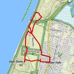
The Listlandtour in the north of the island offers on approximately 10 km length a various view of the protected nature and landscapes of Sylt. Passing mudflats and salt marshes along the Royal Harbour you will reach the western beach, where a lookout dune offers a wonderful panoramic view. With a little luck you can watch porpoises in the sea from the beach! A planked path leads through the dune landscape with heathland and views of the unique shifting sand dunes back to List. On the way there are numerous opportunities for bird watching.
The tour can also be done in 2 stages (from List along the mudflats to the western beach or from the western beach through the dunes to List) and in the opposite direction.
North of Sylt the nature experience continues: Discover the Danish neighboring island Rømø on your next tour! Take the ferry from List to Havneby and start the tour "Along the beach from Havneby to Lakolk" directly at the harbour.
- Directions
-
Start your hike at the Adventure Center "Forces of Nature" in List. If you don't know the center yet, come back for a visit!
Follow the promenade, which after a few meters turns into a sand path and leads you towards "Mövenbergdeich". Along the sand path you will pass the wood-clad Alfred Wegner Institute, a research institute for marine and polar research that has been exploring the Wadden Sea for about 100 years.
The path continues over a fortified dike with a view of the Königshafen - a natural tidal flat bay - and there you will see several sand bendings and the overgrown Uthörn peninsula. With the right equipment in your luggage you will have one of the best opportunities for bird watching on Sylt.
You continue walking to the end of the dike and keep right there. Passing the youth hostel on the left, you will see the salt marshes at the end of the Königshafen on the right.
Continue directly behind the control house for the "Elbow" along the paved path up to the first lookout point. Toll is only paid here if you arrive by car. On foot and by bicycle you can also explore the elbow free of charge from here. However, its circumnavigation is a tour in itself and should not be underestimated.
At the top of the viewpoint you can enjoy a fantastic view over the King's Harbor, the western beach, the entire elbow and the surrounding dune landscape. From here it goes down to the beach. Remember to take your spa card with you! If you are a day guest on the island, you can buy a day guest card (de) at the beach crossing.
Walk south, enjoy the salty breeze and look out for beach finds at the water's edge! After the detour to the beach, take the next dune crossing and follow the road to the east.
As an alternative to the beach excursion, you can walk directly from the viewing dune along the road to the parking lot Weststrand. From April to October you can take the bus line 1 (de) ("Strandverkehr") to Westerland or change at the bus stop "Westerheide/Blidsel" to get back to List.
Another alternative is to walk a longer distance south along the beach and use one of the dune crossings from the height of Süderheidetal/Westerheide to get to the road. From there you can take the bus to Westerland or List.
But on the route described here, turn left at the parking lot Weststrand onto Mövenbergstraße and follow the road back to the youth hostel. Cross the hostel grounds and follow the path to the left, which soon turns into a sand path and leads you into the Lister dune landscape. The sand and later plank path offers a great opportunity to experience the dunes up close without disturbing the sensitive vegetation. A detour of the boardwalk leads on the right hand side over some steps to a viewing platform. From here you have a magnificent view of the unique shifting sand dunes.
At the end of the boardwalk you meet Mövenbergstraße again. Follow the map through the town until you get back to the adventure center or take the next bus in the direction of Westerland at the stop "Mövenbergstraße" (summer timetable) or Kurverwaltung/Alte Schule (all year round).
- Highest point
- 20 m
- Endpoint
-
List harbour / visitor center "Erlebniszentrum Naturgewalten"
- Height profile
-
 © outdooractive.com
 - Equipment
-
With the right clothing, your hike will be an unforgettable experience in any weather! Our tip: With windproof and waterproof clothing, a hat, comfortable hiking shoes, a backpack with a refreshment and some sunscreen, you rarely go wrong on the North Sea.
For bird and plant enthusiasts, it is worth taking binoculars and suitable literature with you - also as an app.
- Safety instructions
-
In order to allow nature to unfold undisturbed, we would like to ask you to support nature conservation in the national park:
Please stay on the marked trails in the National Park and follow the signs for the protection of breeding and resting areas. And even if there are no signs: very nervous birds often indicate that you are too close to their breeding!
Please keep your dog always on a leash when he accompanies you on your journey so that he does not accidentally disturb breeding or resting birds.
Please do not leave any garbage in the nature.
Please do not pick flowers in the national park, because many plants enjoy a special protection. Instead, enjoy their sight on the spot.
Please keep your distance to flocks of birds and seals when you walk along the beach or along the water's edge. - Tips
-
Hike the route along the Königshafen once at low tide and once at high tide: the landscape and bird life are amazingly different!
- Additional information
- Directions
-
Follow Lister Straße to List, then towards the harbor to the visitor center "Erlebniszentrum Naturgewalten". List can be reached by bike on a well-developed bike path, which leads away from the road through beautiful landscapes and is an experience in itself.
- Public transportation
-
By train to Westerland, then by bus (line 1/5) to List to the "List Hafen" stop.
- Parking
-
There is a free parking area right next to the visitor center "Erlebniszentrum Naturgewalten".


-

-
AuthorThe tour WWF Tour Sylt: Listland - heathland, mud & moving dunes is used by outdooractive.com provided.


General info
-
Sylt
45