
- Brief description
-
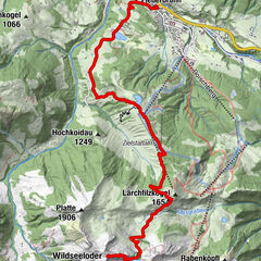
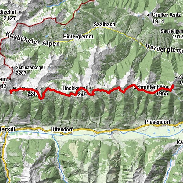
The traditional name "Pinzgauer Spaziergang" trail is an understatement, because the path leads from the Schmittenhöhe to the Bürglhütte in Stuhlfelden and is about 25 km long (without descent).
- Difficulty
-
medium
- Rating
-
- Starting point
-
Schmittenhöhe Zell am See
- Route
-
Berghotel SchmittenhöheEderhütte1.3 kmKettingtörl (1,780 m)1.4 kmKettingkopf (1,865 m)2.0 kmKesselscharte (1,847 m)2.7 kmRohrertörl (1,919 m)5.6 kmKlammscharte (1,993 m)8.1 kmLamperbichlkogel (2,036 m)16.7 kmSommertörl (1,939 m)17.3 kmMurnauer Scharte (1,959 m)23.5 kmBürglhütte25.3 km
- Best season
-
JanFebMarAprMayJunJulAugSepOctNovDec
- Description
-
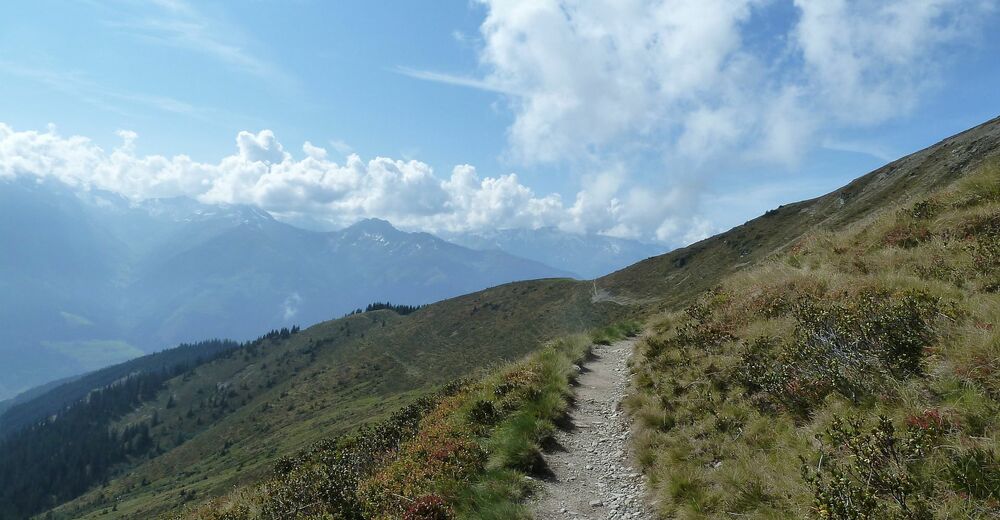
The Pinzgauer Spaziergang trail, at an altitude of around 2,000 metres above sea level, is one of the most beautiful mountain hiking trails in the Eastern Alps with an amazing view of the peaks of Hohe Tauern. During the whole tour, the Salzach valley lies at your feet. Above it, famous peaks such as the Großglockner, the Kitzsteinhorn, the Granatspitze, the Sonnblick and the Großvenediger rise up into the air.
- Directions
-
The starting point of the tour is at the top station of the Schmittenhöhe gondola after a comfortable ascent. The well-marked mountain hiking trail (paths nos. 19 & 719) leads from here in a westerly direction, past Kettingtörl, Kettingkopf, Kesselscharte, Rohrertörl, Kammscharte, Klingler Törl, Medalscharte, Sommertor and over the Murauer Scharte to the Bürglhütte in Stuhlfelden.
NOTE! Hikers with a great stamina can take one or another summit experience with them - please note that the summit ascents are not included in the hiking time! You can descent to any village below - hiking time approx. 3 hours.
Schmittenhöhe - Pinzgauer Hütte - descent to Piesendorf: walking time between 2.5 and 3.5 hrs. Schmittenhöhe - Hochsonnbergalm Piesendorf - descent to Walchen: walking time between 3.5 and 4.5 hrs. Schmittenhöhe - Steinbachriedl - descent to Niedernsill: walking time between 5 and 6 hrs. Schmittenhöhe - Uttendorfer Hochsonnbergalm - descent to Uttendorf: walking time between 7.5 and 8.5 hrs. - Highest point
- 2,093 m
- Endpoint
-
Bürglhütte Stuhlfelden
- Height profile
-

- Equipment
-
Endurance, sturdy footwear and a certain level of surefootedness are required. There are no open huts along the Pinzgauer Spaziergang. Take sufficient supplies (snacks & drinks) with you.
- Safety instructions
-
Dear nature lovers!
We hope that the snacks and drinks you take with you on your hike will give you the strength to carry back the packaging material and empty cans and bottles.We kindly ask you to observe the Fair Play & Rules of Conduct!
Fairness and mutual consideration form the basis for a common together and the protection of the various interests in the natural region!
- Tips
-
The managed huts are not located directly at the Pinzgauer Spaziergang.
- Additional information
- Public transportation
- Parking
-
There are sufficient parking facilities available at the valley station of the Schmittenhöhebahn.


- Author
-
The tour Pinzgauer Spaziergang - Mountain hiking trail is used by outdooractive.com provided.


General info
-
Saalbach Hinterglemm
1581
-
Uttendorf - Weissee
369