
- Brief description
-
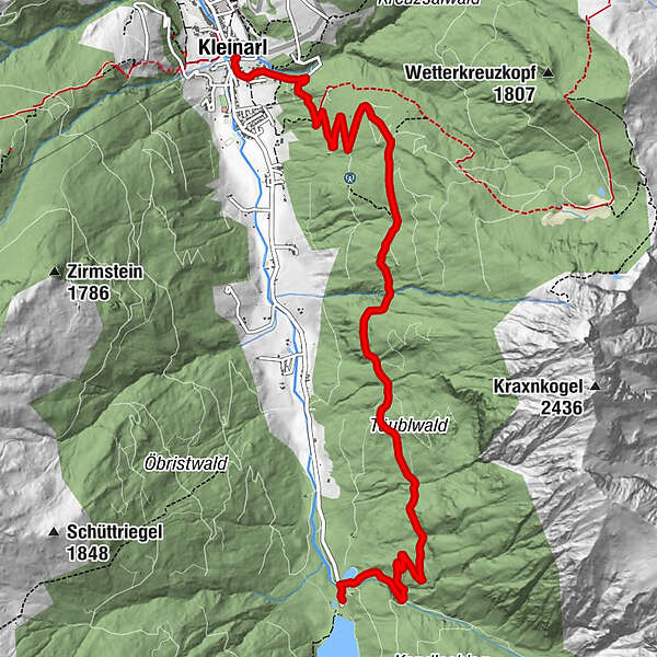
Hike over the Täublwaldstraße and over the Hochstein to the center of Kleinarl!
- Difficulty
-
medium
- Rating
-
- Starting point
-
Starting point Jägersee bus stop
- Route
-
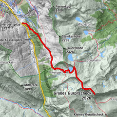
Pfarrkirche zum hl. Laurentius8.4 kmKleinarl8.4 km
- Best season
-
JanFebMarAprMayJunJulAugSepOctNovDec
- Description
-
You start at the Kleinarl Jägersee or directly at the local bus stop "Jägersee" and walk about 200m along the main road towards Kleinarl. After the bridge, Täublwaldstraße (No. 78) begins on the right, which you follow for about 3 km until you come to the Hochsteinweg junction. Now the descent begins over the Hochstein to the center of Kleinarl.If you have your car at Jägersee, you can take the public bus from Kleinarl to Jägersee.
- Highest point
- 1,403 m
- Endpoint
-
Kleinarl center
- Height profile
-

- Equipment
-
Good shoes, a small snack, a drinking bottle
- Directions
-
Arrival by car on the Tauern Autobahn A10 - take the Flachau exit - at the second roundabout continue in direction Wagrain-Kleinarl - now follow the main road for about 8 km to the center of Wagrain - at the intersection at Sport Obermoser in the center of Wagrain, turn Turn left in direction Kleinarl. Now follow the main road or the country road for approx. 12 km and drive to the end of the valley to the Jägersee. Your hike begins here.
- Public transportation
-
public bus
- Parking
-
car park Jägersee

-

-
AuthorThe tour Täublwaldstraße is used by outdooractive.com provided.