- Brief description
-
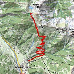
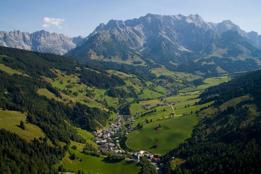
Take the time with your family and enjoy a beautiful walk from the village of Dienten to the Keilbrücke/Fischerstüberl.
- Difficulty
-
easy
- Rating
-
- Starting point
-
Dienten village or Fischerstüberl/Keilbrücke
- Best season
-
JanFebMarAprMayJunJulAugSepOctNovDec
- Description
-
At the southern end of the village of Dienten, the Erlenweg (alder path) runs parallel to the road and the Dientner river stream for approx. 3 km to the former "Fischerstüberl" (closed!). (Can also be walked with prams)
This path is also suitable as a way back to the village centre after hikes with the end point Fischerstückerl/Keilbrücke.
- Directions
-
At the southern end of the village of Dienten, the Erlenweg (alder path) runs parallel to the road and the Dientner Bach stream for approx. 3 km to the "Fischerstüberl" (closed). (Can also be walked with prams)
This path is also suitable as an evening walk or as a way back to the village centre after hikes with the end point Fischerstückerl/Keilbrücke.
OR
You start at the Fischerstüberl and so this is perfect as a return route from hikes with the end point Fischerstüberl/Keilbrücke. From there you walk along the Dientner Ache parallel to the Dientner Landesstraße into the village. After about 400 metres, turn right onto a signposted narrow path past the football pitch into the centre of Dienten. - Highest point
- 1,025 m
- Endpoint
-
Fischerstüberl/Keilbrücke oder Dorf Dienten
- Height profile
-

- Equipment
-
Sturdy, ankle-high footwear
Walking sticks
Headgear
Sun protection
Sunglasses
Rain protectin
Drinks and a snack
Necessary medication
First aid kit
Hiking map - Safety instructions
-
Weather forecasts Take note of the current weather conditions at: www.zamg.at
Together Follow the 10 rules for the correct handling of grazing animals and do not leave any waste in nature!
Do not kick stones Do not kick stones as this can seriously endanger other hikers. Marked places with a danger of falling rocks should be crossed as quickly as possible and with attention and caution.
Turn back in good time This is not a disgrace, but a sign of common sense. It becomes necessary when the weather changes, fog rolls in, and also when the path is too difficult or not in good condition.Emergency numbers: Alpine emergency call: 140
International emergency call: 122 - Tips
-
This path is also suitable as an evening walk and is suitable for prams.
- Additional information
- Directions
-
Coming from Salzburg: Take the A10 freeway to the Bischofshofen exit, then take the B311 in the direction of Bischofshofen. Follow the Hochkönig Bundesstraße/B164 to Mühlbach and further to Dienten.
Coming from Innsbruck/ Kufstein: On the Loferer Straße/B178 in the direction of St. Johann i.T., then on the Hochkönig Bundesstraße/B164 via Saalfelden and Maria Alm to Dienten or to the Filzensattel.
A valid vignette is required to use the Austrian motorway and motorway network. It is also compulsory to carry a first-aid kit, warning triangle and high-visibility waistcoat. Further information can be found under Asfinag. - Public transportation
- Parking
-
Free parking at the Fischerstüberl/Keilbrücke and at the Grünegg Alm car park
- Author
-
The tour FAMILY WALKING ROUTE Erlenweg is used by outdooractive.com provided.


-
Hochkönig
2016
-
Dienten am Hochkönig
536