
- Brief description
-
3-day tour / 2 nights in alpine huts
- Difficulty
-
difficult
- Rating
-
- Starting point
-
market square Abtenau
- Route
-
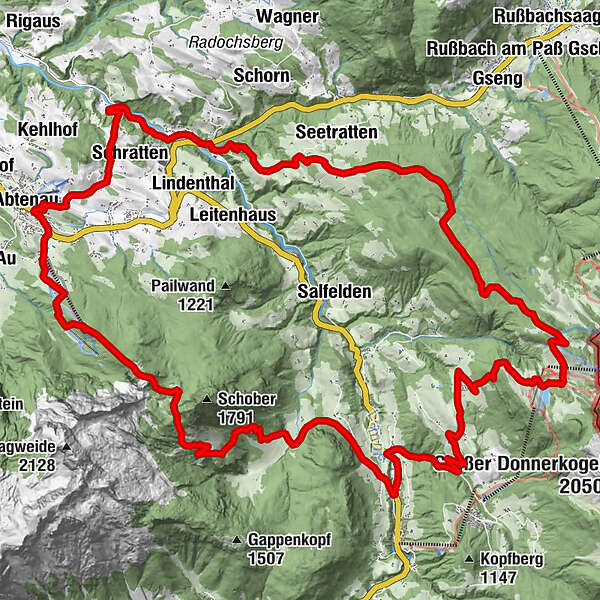
MarktAbtenauSchratten2.0 kmGschwandtleiten6.9 kmHallseiten7.2 kmReit8.1 kmSeetratten8.5 kmGschwandt9.0 kmKlockaualm11.7 kmRottenhofhütte16.7 kmBraunötzhof19.6 kmAnnaberg im Lammertal24.3 kmHefenscher25.0 kmLehen26.0 kmQuehenberg27.3 kmMaxwassal31.2 kmGsengalmhütte31.6 kmKarkogelhütte33.8 kmKarkogelbahn33.8 kmMarkt36.7 kmAbtenau36.8 km
- Best season
-
JanFebMarAprMayJunJulAugSepOctNovDec
- Description
-
From Abtenau take trail no. 173 north via Erlmoos to the Lammer, follow this along trail no. 174 to the Schwaighofbrücke junction. Cross the main road to the riding and tennis hall. Opposite the tennis hall, turn left onto trail 24 via Gschwandt and Klockaualm towards Zwieselalm. Shortly before the Zwieselalm, take the turnoff to the right onto trail no. 50. After approx. 30 min you reach the Rottenhofhütte (overnight stay).Follow trail no. 50 in the direction of Annaberg. Now turn left and follow the main road to the bridge over the Lammer. There turn right onto the Salzalpensteig trail towards Quehenberg. Now continue along the Salzalpensteig in the direction of Gsengalm over the Gsenghöhe. Gsengalm overnight stay.Hike the Salzalpensteig trail to the Karkogel, then hike along trail no. 25 along the Karkogel to Abtenau.
- Directions
-
Day 1 - Abtenau - Rottenhof Hut
The first day of the tour starts in Abtenau at the market square, from there we march right past the church and then continue on hiking trail no. 170 in the direction of the Gasthof zur Sonnleit'n. Hiking trail no. 170 leads along a small asphalt road along the district of Schratten, after approx. 2.5 km you come to a junction. Here we then follow trail no. 173 to the left into the forest. Trail no. 173 leads for approx. 2.2 km alternately through forests and along sunny meadows until, after a short stretch downhill, you reach the river Lammer at the end. Our hike now takes us further upstream, along the Lammer glistening in the sunlight on an asphalt road with trail no. 174, approx. 1.8 km to the Schwaighof bridge on the main road 166. Please take care - we now cross the main road to reach the next turn-off to the Reitgut Lammertal (large green signs) on the right. On the way to the Reitgut, after a small bridge on the left, there is a gravel car park where trail no. 180 begins, which takes us further up to the Seetratten district. Trail 180 (asphalt road) leads us mostly through a dense forest. After about 350 m, the path begins to rise sharply and then leads up the mountain in a serpentine line. It winds through the forest for about 900 m until you reach a clearing, where you are immediately rewarded with a beautiful view. On the further way, we can now soak up the sun again, because it now leads slightly uphill past beautiful green meadows and small farms. After about 1.2 km, there is another junction directly in front of a farm. At this fork we keep to the right and after about 230 m at another fork we take the path to the left in the direction of Zwieselalm. Now hiking trail no. 24 leads us further to our destination. We continue hiking slightly uphill until we reach a barrier, where the asphalt road ends and a gravel path begins. Continue on the gravel path (hiking trail no. 24) through the forest, always in the direction of Zwieselalm. After about 2.6 km, the trail also leads us to a large clearing at the Klockaualm, where trail no. 24 and trail no. 47 meet. We stay on trail no. 24 in the direction of Zwieselalm and enjoy the fresh forest air while walking along the gravel path. After about 3.2 km we are just before the Zwieselalm, from here it is not far to our destination for the first day: the Rottenhofhütte. We have to turn right onto a small meadow path with the numbers 50 and 50c. At the end of the path is the Rottenhofhütte where the first day of our exciting tour now ends.
Day 2 - Rottenhofhütte - Gsengalm
Well fortified by a hearty hut breakfast, we start the second day of our tour. We now leave the Rottenhofhütte in the direction of the valley to the village of Annaberg. Via a gravel path with hiking trail no. 50 we march comfortably downhill into the valley. After about 1.4 km, we take a small shortcut to the right through the forest, which ends after about 500m on the gravel road again. The gravel road now turns into an asphalt road, trail no. 51, which takes us downhill for about 4.6 km, past the Hagenmühle mill, to the main road 166. When we reach the main road, we turn left towards the idyllic village of Annaberg. After a walk of approx. 800 m, we cross the small bridge on the right and now follow hiking trail no. 56 (Salzalpensteig) uphill into the Hefenscher district. We walk for approx. 2.4 km, first on a small asphalt road and then on a hiking trail through the forest until we reach the Quehenberg farm. From Quehenberg we hike comfortably on a shotter trail with trail no. 223 (Salzalpensteig again) back to the Quehenbergalm. At the Quehenbergalm, we keep to the right, leave the gravel path and follow a trail with trail no. 226 through meadows and mountain pines. The path leads us past the foot of the summit of the Schober (1810m) to our destination, the Gsengalm, where our second day ends.
Day 3 - Gsengalm - Abtenau
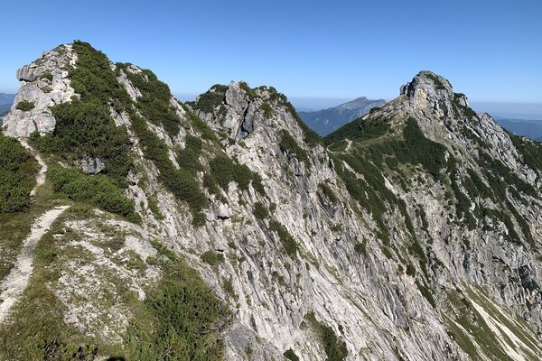
After a beautiful sunrise on the Gsengalm we already start the third and last day of our tour back to Abtenau. First we start with the high-altitude trail no. 27 (Salzalpensteig) from the Gsengalm to the Karalm, which gives us special views of the Kleiner Traunstein (1659m), before we reach the Karalm via the Karriedel. From the Karalm we admire the wide view over the village of Abtenau and the Tennengebirge before we start our descent towards the Karkogeltalstation via the 2.5 km long gravel road with trail no. 27. The trail still takes us past the summer toboggan run to the valley station and then from there via the approx. 1.4 km long trail no. 110 back to the sunny market square in Abtenau. Arriving at the market square, we look back on four eventful and sporty days and look forward to the next tour.
- Highest point
- 1,592 m
- Endpoint
-
market square Abtenau
- Height profile
-

- Equipment
-
sturdy shoes, walking sticks are an advantage
- Parking
-
east car park in Abtenau village centre (free parking)
- Author
-
The tour Abtenau - Rottenhof - Gsengalm - Abtenau is used by outdooractive.com provided.