

- Brief description
-
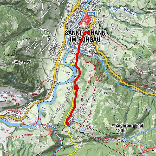
Vom Stadtzentrum ins Alpendorf bzw. umgekehrt - über die Alpendorfstraße und den Grubhof.
- Difficulty
-
medium
- Rating
-
- Starting point
-
St. Johann
- Route
-
Pfarrkirche St. JohannEvang. Annakapelle0.0 kmSankt Johann im Pongau0.2 kmSankt Johann im Pongau0.4 kmAlpendorf3.7 km
- Best season
-
JanFebMarAprMayJunJulAugSepOctNovDec
- Description
-
The starting point for this hike is the town centre of St. Johann. From Pongau Cathedral you follow Hauptstrasse (main road) downhill through the town centre to the Liechtensteinklammstrasse, this leads into the Alpendorfstrasse. Walk along the Alpendorfstrasse as far as the Grubhof (first farm left). From here take the Alpendorf Promenade passing Hotel Alpenschlössl and Hotel Tannenhof, until you find yourself in the Alpendorf.
You can take the same route back or you can follow one of the other hiking trails back into the town centre – see hikes "St. Johann - Alpendorf (via Ötzmoos)" and "St. Johann - Alpendorf (via Zederberg)". Otherwise you can take a public transport bus (route 540 St. Johann – Grossarl). Current departure times are available at the bus station behind the post office in the town centre, at the tourist office or from your hosts.
This hike is also possible the other way round, from the Alpendorf into the town centre.
- Highest point
- 734 m
- Endpoint
-
Alpendorf
- Height profile
-

- Author
-
The tour St. Johann - Alpendorf (via Grubhof) is used by outdooractive.com provided.