


- Brief description
-
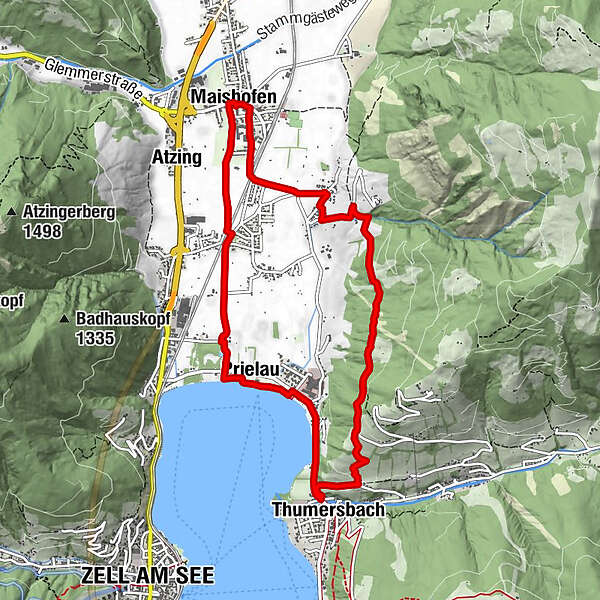
A well varied circuit combining a good track high on the hillside, linking the villages of Maishofen and Thumersbach, with part of the north shore of the Zellersee.
- Difficulty
-
medium
- Rating
-
- Route
-
Maishofen0.0 kmMayerhofen1.4 kmThumersbach5.3 kmWiesenlehen6.0 kmGasthof Wieshof6.3 kmPrielau6.9 kmPrielaukirche7.5 kmUnterreit8.2 kmBadhausfeld8.3 kmAtzing8.9 kmMaishofen9.5 km
- Description
-
Maishofen, Thumersbach & The Zellersee
A well varied circuit combining a good track high on the hillside, linking the villages of Maishofen and Thumersbach, with part of the north shore of the Zellersee. The return is across level farming land. The views, particularly from the high ground to the mountains behind Kaprun, are excellent. Maishofen and Thumersbach are pleasant villages, each with a few shops, cafes and other facilities. The north shore of the Zellersee has varied visitor provisions, including bathing, boat hire and café.
WALK
Turn right out of the car park, passing the bakery/café. Turn right into Mayrhofen Strasse. Walk along the side of this quiet road, passing a children’s play area, then the fire station on the left. Go under the railway line and keep straight ahead at a junction. The road is now a country lane across farming land, passing the Maishofen boundary sign.
1. At a junction with signs follow ‘Zum Maishofen weg 92’ bearing slightly left. At Mayrhofen hamlet fork right, then turn right in a further 20m. Turn left into Tradlweg, a modern residential road.
2. At a ‘T’ junction turn left along an unsurfaced roadway to commence the ascent by the side of a rushing stream. The rise is steady, soon with views of Maishofen village. Cross a cattle grid.
3. In a further 100m, turn right for ‘Maishofen Hoehenweg 92 Thumersbach’. Cross a bridge over a stream, continuing to rise steadily, with good views. Pass a barrier/turnstile.
4. At a signposted junction go right for ‘Maishofen Hoehenweg and Thumersbach’. There is also a red and white waymark. After barely a short length of narrow path through woodland’. The top of the Schmittenhoehe, behind Zell am See, is visible. Reach a barrier, then a junction with a ‘Thumersbach 30 minutes’ signpost. Continue downhill.
5. At a signposted junction immediately before a farm, turn right, downhill, soon passing another sign. The super views include Zell am See, its lake and the Kitzsteinhorn behind Kaprun. Descend across a meadow to a seat, then a waymark on a hut. Pass a small farm building, with waymark, then bear left along the side of a hedge; a farm building has another waymark. Continue down a section where hedges on both sides of the path make a tunnel. Reach the top end of a lane, by a house. At a signposted junction turn right ‘Thumersbach 10 minutes’. Continue to descend, past a waymarked hut, reaching the main road on the edge of Thumersbach, opposite the entrance to the Kurpark. Also opposite are public conveniences. To visit the village centre a short diversion to the left is required.
6. Turn right, along the roadside.
7. Just past the hospital turn left along a pathway to reach the lake shore. Continue along the delightful lake shore track, cross a bridge over a stream then pass a cafe, a caravan park and another bridge, in 100m, immediately before a third bridge, turn right. There is a ‘Schloss Prielau’ sign.
8. Reach the road in 70m. Go straight across to Hofmannsthalstrase, passing a ‘Maishofen’ sign. Pass the Prielau hotel/restaurant, turn right at a ‘Maishofen’ signposted junction, and continue along a very minor road across a wide area of valley bottom farming land. Go straight across at a crossroads. By a cluster of houses turn left to pass under the railway line.
9. In 50m turn right to follow a grass path ‘signposted Wiesenweg n. Maishofen which goes all the way to Maishofen village centre.
Approaching the centre, ignore any tracks to the right. Finish at the village main street, within 100m of the car park. Turn right to return.
Click here for further details about HPB Viehhofen; where 7 holiday units form the perfect retreat following a day's skiing or walking in an area of inspiring natural beauty. - Highest point
- 970 m
- Height profile
-


-

-
AuthorThe tour HPB Viehhofen: Maishofen & Thumersbach is used by outdooractive.com provided.
GPS Downloads


Other tours in the regions
-
Zell am See - Kaprun
1503
-
Maishofen
517


