- Brief description
- Difficulty
-
medium
- Rating
-
- Starting point
-
Valley station Almenwelt Lofer
- Route
-
LoferAlmbahn I (1,000 m)0.0 kmLoderbichl1.8 kmBimalm4.1 kmSoderkaser4.9 kmAlmbahn II (1,350 m)5.0 kmSteger Kaserei5.3 kmSkihütte Schönblick5.5 kmSkihütte Restaurant Almtreff6.6 kmLochtretalm12.6 kmFriedlwirt20.9 kmUnkenboden23.1 kmUnken24.1 km
- Best season
-
JanFebMarAprMayJunJulAugSepOctNovDec
- Description
-
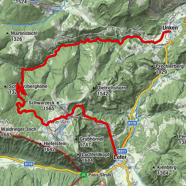
The 2nd hiking day also starts in Lofer. Take the Almbahn I to Loderbichl and walk along the waterfall trail to the Loferer Alm. After an extensive rest in the Almenwelt Lofer, you then hike downhill via the Schwarzbergklamm and the Eiblklamm to the Friedlwirt and on to Unken.
- Directions
-
We take the cable car Almbahn I to Loderbichl/middle station and hike along the beautiful Wasserfall Weg (no. 50/waterfalls) to the Loferer Alm. To save some energy and time we can, of course, take the second cable car too, to get to the top. The choice is yours!
From the mountain station of Almbahn II we take the path to “Haus Schönblick” (restaurant), from there we take path no. 201 for a short distance, before we turn right to follow the path direction to Fußtal (Unken). When we reach the Fußtalstube, we take the right path to Schwarzbergalm - Lochtretalm until the Schwarzbergklamm (gorge). This area belongs to the Bayerischen Saalforste (governmental Bavarian forest enterprise) even though it is Austrian territory. The Schwarzbergklamm (gorge) is said to be one of the most tremendous gorges in the Alpine region.
It is impressive how this water has washed a channel into the rock during the last couple of thousand years. On the left side, there is a trail to the “Muckklause” and the Bavarian “Winklmoos Alm”. We head to the right side descending to “Eiblklamm” with gorgeous rock formations and via a traffic-free road ca. 6 kilometers to Gasthof Friedlwirt (restaurant). For the last two kilometers of the day to Unken, we take the asphalt road.
Time: ca. 8 hours (from the mountain station of Almbahn II ca. 6 hours)
1st option: We start again in the direction of “Haus Schönblick” (restaurant), after about 50 meters we turn right to get to the Schwarzeckalm (alp) via grassy pastures. From here we have a great 360°-panoramic view, including the city of Salzburg, the lake Chiemsee and many 2000 m high peaks. We follow the gravel path (which is closed to traffic) and pass the Dietrichshorn to our right to get to Hoisenhöhe. From there via Unkenberger Mähder, Daxbauer (farm), Unkenberg and “Gasthof Dietrichshorn” (restaurant) descending continuously to Unken. Time: ca. 6 hours
2nd option: We take the same route as the main tour until we reach Schwarzberglkamm (gorge). Again we turn right to reach the Engstube, where we turn left to cross the Unkenbach (stream) on a small footbridge. We use the Gföll-Steig to come to “Gasthaus Hintergföll” (restaurant). From there on we use the asphalt road for ca 2 km to get to “Gasthaus Friedlwirt” (restaurant) via the Alte Gföller Straße (road). For the last two kilometers we use the asphalt road to get to Unken.
Time: ca 6 hours
- Highest point
- 1,454 m
- Endpoint
-
Unken
- Height profile
-

- Equipment
-
Clothing: Comfortable walking shoes, breathable clothing depending on the weather (T-shirt, light trousers).
Equipment: Small backpack, sunscreen, hat or cap, first aid kit, mobile phone.
Food: Sufficient water, snacks (energy bars, nuts, dried fruit).
Navigation aids: Map or hiking app, compass (optional).
Other: Light pocket knife or multitool, insect repellent (if needed).
As needed: rain jacket, sunglasses.
- Additional information
-
Package Hiking without luggage
Trekking Tour on the Route of the gorges:
Lofer - Loferer Alm - Unken - Reith - St. Martin - Weißbach - Lofer7 overnight stays – 6 hikingdays. Hiking from village to village and the luggage will be brought to your next accommodation daily
By booking the package, we can guarantee that the accommodations will be available for 1 night in different locations.
- Directions
-
Take the B311 or B178 to Lofer, at the roundabout continue in the direction of Salzburg. 300 metres later you will find the Lofer car park (5090 Lofer, Lofer 310).
- Public transportation
- Parking
-
Large car park in Lofer, free of charge
-

-
AuthorThe tour Route of the Gorges - Hikingday no. 2 is used by outdooractive.com provided.