

© Saalbach Hinterglemm - Paul Kubalek
- Brief description
-
After the initial steep climb an easygoing hike
- Difficulty
-
medium
- Rating
-
- Starting point
-
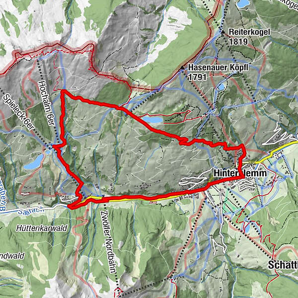
Hasenbachweg Hinterglemm
- Route
-
Hinterglemm0.0 kmHasenau0.2 kmEdelweiss Alpenkino2.0 kmRoßwaldhütte3.4 kmSonnhof5.9 kmEiböckalm7.1 kmHinterglemm10.6 km
- Best season
-
JanFebMarAprMayJunJulAugSepOctNovDec
- Description
-
Walk along the Hasenbachweg to the well signposted woodlands. Continue under the Reiterkogel lift and onto the village area "Kolling".
Possible detour via Oberwalleggalm.
Return on the Saalachpromenade to Hinterglemm or take the Wanderbus back.
- Highest point
- 1,648 m
- Endpoint
-
Centre Hinterglemm
- Height profile
-

- Directions
-
From Maishofen approx. 18 km along the L111 to Hinterglemm (Hinterglemm east) and the park house Reiterkogel
- Public transportation
-
Postbus - daily from 07.00 - 19.00
http://www.postbus.at/de/Fahrplanauskunft/Fahrplandownload/index.jsp
- Parking
-
Park house Reiterkogel Hinterglemm

- Author
-
The tour Höhenweg 4 is used by outdooractive.com provided.
GPS Downloads


General info
Refreshment stop
A lot of view
Other tours in the regions
-
Saalbach Hinterglemm
1581
-
Fieberbrunn
410


