- Brief description
-
1st Hiking day
- Difficulty
-
medium
- Rating
-
- Starting point
-
Start Huggenberg chair lift
- Route
-
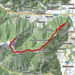
Hinterburg Stub'n0.0 kmHuggenberg Alm1.0 kmBerggasthof Biberg3.2 kmDurchenkopf (1,764 m)7.1 kmHaiderbergkogel (1,875 m)7.9 kmSausteigen (1,912 m)8.9 kmGstallneralm11.2 kmGadenstättalm12.3 kmMaishofen16.6 km
- Best season
-
JanFebMarAprMayJunJulAugSepOctNovDec
- Description
-
Start Huggenberg chair lift
Huggenbergalm (rest point)
Berggasthof Biberg (rest point)
Saalachtaler Höhenweg
Weikersbacher Köpfl
Durchenkopf
Sausteige
Jahnhütte (no service)
Maishofen
- Directions
-
At the bottom station of the Huggenberg lift, you can use the chairlift to ascend to Huggenberg or follow the goods path on foot. The first destination is the Biberg mountain inn. Continue along the Saalachtaler Höhenweg along the mountain ridge and to the summit of the Durchenkopf, towards the Haiderbergkogel. Here you follow the signs „zur Sausteige“ and leave the Saalachtaler Höhenweg. You then reach the summit cross of the Sausteige. With a view of the „Zeller lake“, you now descend „to Maishofen“ via the Gstallneralm, the Gadenstättalm and the Stablberg snack station.
Alternative variants: After the Weikersbacher Köpfl 1616 m, the path branches off to the left to the Örgenbauernalm (Variation C).
After another 20 minutes you'll have the next opportunity to take a left to a shorter (Variation B) of the day's hike to Maishofen.
- Highest point
- 1,907 m
- Endpoint
-
Maishofen
- Height profile
-
- Equipment
-
climbing boots, sun cream, map of trails, first-aid equipment, cagoule, beverage / food, binoculars
- Safety instructions
-
European Emergency Number: 112
Austrian Mountain Rescue Service: 140
Please note the opening hours of the alpine huts!
- Additional information
-

-
AuthorThe tour Saalachtal Tour SHORT - 1st Hiking day is used by outdooractive.com provided.
General info
-
Saalfelden - Leogang
1787
-
Maishofen
517


