


- Brief description
-
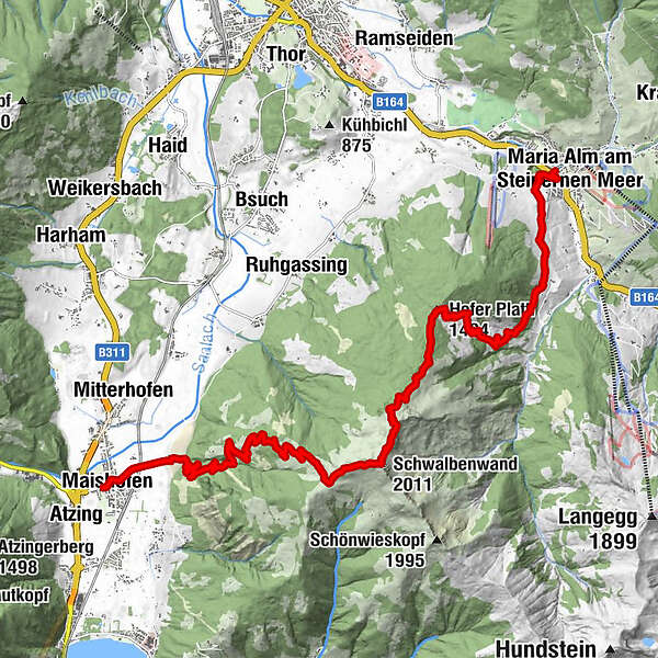
2nd Hiking Day
- Difficulty
-
medium
- Rating
-
- Starting point
-
Maishofen
- Route
-
Maishofen0.1 kmSchloss Kammer1.3 kmKammeregg Alm4.7 kmSchwalbenwand (2,011 m)8.4 kmHofer Plattl (1,404 m)11.7 kmHinterjetzbachalm13.3 kmArbesreitalm14.0 kmSchattberg16.0 kmFriedenskapelle17.0 kmSchloßberg17.2 kmMaria Alm am Steinernen Meer17.3 km
- Best season
-
JanFebMarAprMayJunJulAugSepOctNovDec
- Description
-
Maishofen
Kammereggalm (rest point)
Schwalbenwand
Hofer-Hochberghütte (no service)
Unterjetzbachalm (rest point)
Maria Alm
- Directions
-
From the accommodation you start in the direction of Schloss Kammer, here you follow the goods path in the direction of Schwalbenwand. Past the Kammereggalm and Dillingalm, you reach the summit cross of the small and then the large Schwalbenwand. The descent leads in the direction of Brunnkopf, past the Hofer-Hochberg-hütte to the Hofer Plattl. Then you pass the Oberstegalm and reach the Hinterjetzbachalm. It is then about 60 minutes to the centre of Maria Alm.
- Highest point
- 2,008 m
- Endpoint
-
Maria Alm
- Height profile
-

- Equipment
-
climbing boots, map of trails, first-aid equipment,
cagoule, sun cream, beverage / food, binoculars
- Safety instructions
-
European Emergency Number: 112
Austrian Mountain Rescue Service: 140
Please note the opening hours of the alpine huts!
- Additional information
-
The long-distance hike is bookable as a package "Hiking without luggage" under Saalfelden Leogang
Here is the timetable for public transport on site
The normal route for this day's hike takes you over the summit of the Schwalbenwand and offers no restaurant stop until the early afternoon, so be sure to take enough food and water along with you. You should also keep in mind that this tour takes you up to 2000 meters' elevation over open terrain, so you should undertake this hike only in good weather. The valley route (B) is the alternate choice.

-

-
AuthorThe tour Saalachtal Tour - 2nd Hiking Day is used by outdooractive.com provided.


-
Saalfelden - Leogang
1787
-
Maria Alm
489


