- Brief description
-
Come and enjoy the summer scenery in beautiful Mühlbach as you walk through and round our village.
- Difficulty
-
easy
- Rating
-
- Starting point
-
Tourist Office Mühlbach
- Route
-
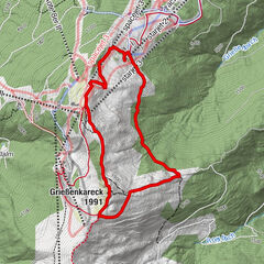
Mühlbach am Hochkönig0.2 kmSchlöglberg0.9 kmHöring2.3 kmAnderlwirt2.3 kmMesnerhaus, Café, Bar & Restaurant2.3 kmPfarrkirche zum hl. Sebastian2.3 km
- Best season
-
JanFebMarAprMayJunJulAugSepOctNovDec
- Description
-
From the Tourist Office, turn left. Before Café Höring turn left and cross over the bridge. Continue straight on following path Nr. 17 - go uphill past Alpin Hotel Marmotta and keep going until you get to the tarmac road. At this small intersection turn right and follow the road, going downhill until you get to the path (Ski weg). Here, turn right and go along the path (Ski weg) back to the village.
- Directions
-
Start in front of our tourist office to the left. Before the restaurant "Zum Steirer" turn left and cross the bridge. Go straight on, follow path no. 17 - past the Alpin Hotel Marmotta to the asphalt road. At the crossroads turn right and follow the road downhill again until you reach the ski path. Here you turn right and follow the road back into the village.
- Highest point
- 945 m
- Endpoint
-
Tourist Office Mühlbach
- Height profile
-

- Equipment
-
Good walking shoes , possibly rain gear, something to drink.
- Safety instructions
-
especially with new snow "danger of slipping
- Tips
-
Lunch at the restaurant "Zum Steirer
- Additional information
- Directions
-
Hochkönigbundesstraße B164
- Public transportation
- Parking
-
Parking opposite the fire department.


- Author
-
The tour Local Walking Route "Marmotta" is used by outdooractive.com provided.