- Brief description
-
Hike over the Turnaualm, a beautiful, quiet alpine area with several old huts to the Tabor.
- Difficulty
-
medium
- Rating
-
- Starting point
-
Village Square Russbach
- Route
-
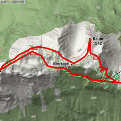
RußbachsaagPfarrkirche zum Hl. KreuzKirchenwirt0.0 kmRinnbergalmen3.8 kmTabor (1,618 m)10.8 kmRinnbergalmen18.0 kmRußbachsaag21.7 kmPfarrkirche zum Hl. Kreuz21.7 kmKirchenwirt21.8 km
- Best season
-
JanFebMarAprMayJunJulAugSepOctNovDec
- Description
-
From Russbach you can reach wonderful alpine pastures in a relatively short time. The circular route takes you first to the Traunwandalm, then via the Angerkaralm to the Rinnbergalm. On the way you will learn all sorts of interesting things about life on the alpine pasture. The management of the pastures was once a hard and deprived work. We should imagine them less romantic and relaxing than today may seem to arouse the appearance. In addition to the supervision of the cattle, the cultivation of butter-malt, scotch and cheese was the focus of the farms. Fortunately, cheese production on the pastures has recently undergone a renaissance in the course of tourism and all hikers are well advised to try it.
- Directions
-
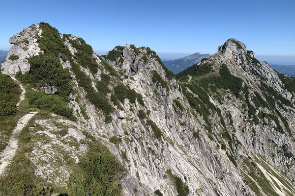
As far as the Rinnbergalm take trailNo. 32. At the Rinnbergalm, the forestryroad continues left in the direction ofTurnaualm–Taborberg. At the turn-offkeep right heading up the Bodenberg.After ca. 15 mins. of walking, path32B meets up with No. 23(Taborrundweg). Continue left to theTurnaualm. Summiteers can branch offjust before the Turnaualm and headup the Taborberg (No. 23A). Crossing open alpine grazing areas, you will walk (in theopposite direction to the signs) via a steadily climbing hiking path to the summit (1618m). Hike down the same way. The Turnaualm is a beautiful, peaceful area of highpastures with numerous old mountain huts – however, no facilities available.
- Highest point
- 1,577 m
- Endpoint
-
Village Square Russbach
- Height profile
-

- Equipment
-
Hard shoes, rain jacket and a snack are recommended.
- Tips
-
The alpine huts are open from the end of June to September and the dairy farmers serve excellent, homemade cheese specialties
- Directions
-
Coming from the A10 motorway, take the exit Golling direction Abtenau and Russbach. From Bad Ischl you drive via Bad Goisern and Gosau to Russbach.
- Public transportation
- Parking
-
You will find enough parking area in the center of Russbach or at the parking area „Rinnbach“

- Author
-
The tour Russbach: Rinnbergalm-Turnaualm-Tabor is used by outdooractive.com provided.