Winter
Summer
Weather
Webcams
Accommodations
Tours
Search history
Search suggestions
No results found
Search
Tours
Home
Summer Österreich
Salzburg
Tours
Wanderung
Regions
Weather
Webcams
Tours
Highlights
Bathing lakes
Accommodations
Offers
Sports provider
Events
Ski resorts
Cross-country skiing
Snow parks
Wanderung
Hiking
Bookmark
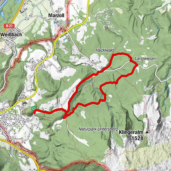
Map
show
hide
Print
Tour data
9.3
km
572 - 676
m
Distance
126
hm
60
hm
Ascent
02:19
h
Duration
NiklasB
created am 05.05.2017
258
Views
Rating
Technique
Fitness
Landscape
Experience
Highest point
676 m
Write a review
Overall rating
5
0
%
4
0
%
3
0
%
2
0
%
1
0
%
Reviews
(0)
0 Comments
Write a review
Error
An error has occurred. Please try again.
Thank you for your review
Rating has been deleted
Report tour
GPS Downloads
GPX
GPS Exchange Format (XML)
KML
Google Earth, Google Maps
QR Download Codes for Mobile Phones
Wanderung
QR Codes - tour download for cell phones
GPX
KML
Other tours in the regions
Berchtesgadener Land
1609
Großgmain
542
Popular tours in the area
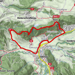
Mühlenweg Ebenau und Naturdenkmal Plötz
medium
Hiking
5.35
km |
181
hm |
02:00
h
Dötzenkopf
medium
Hiking
2.03
km |
399
hm |
02:15
h
Nockstein
easy
Hiking
3.35
km |
160
hm |
02:00
h
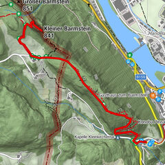
Wanderung zum Kleinen Barmstein über die Ruine Thürndl
difficult
Hiking
4.2
km |
291
hm |
01:40
h
No entries found.
The search is currently not available.
Please refine your search.
Local search results
(<= 25km)
More results
(> 25km)
%count% Search results
%name%
%type%
%elevation%
%population%
%lpButton%