- Brief description
-
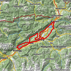
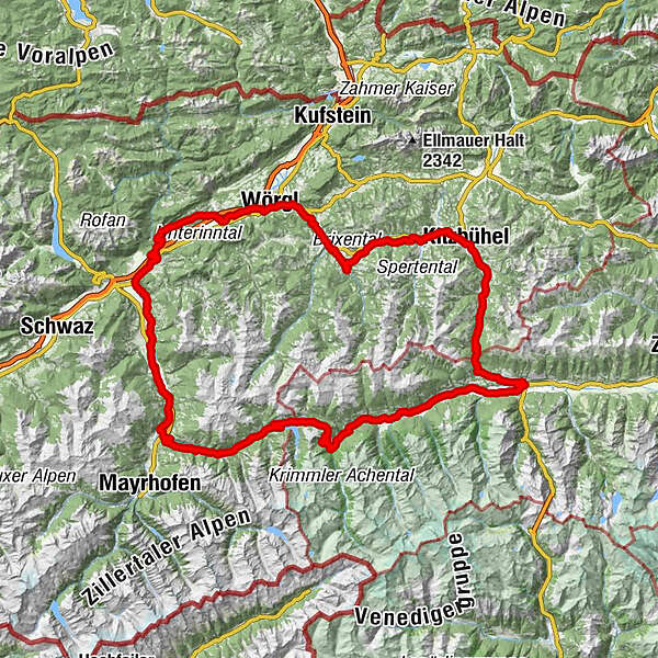
A circular route over two pass roads and federal lands
- Difficulty
-
difficult
- Rating
-
- Route
-
Krimml (1,067 m)Pfarrkirche Krimml0.0 kmKehre 1 / Burgwald (1,135 m)1.6 kmKehre 2 / Trattenköpfl (1,167 m)2.2 kmKehre 4 (1,353 m)4.5 kmKehre 5 (1,384 m)4.9 kmKehre 6 (1,419 m)5.4 kmKehre 75.5 kmAlmhotel Schönmoosalm (1,493 m)5.5 kmKehre 8 / Schönmoosalm (1,167 m)5.8 kmKlausboden16.2 kmInnertal18.5 kmJägerstüberl19.0 kmIsskogelstüberl19.1 kmOberhof19.2 kmMitterhof19.5 kmGaspi's Woodfired Grill20.1 kmGerlos (1,247 m)20.1 kmRied20.7 kmGmünd22.9 kmKapelle Kühle Rast24.3 kmHainzenberg (910 m)32.1 kmWaidachhof33.9 kmZell am Ziller (575 m)37.3 kmZellbergeben37.5 kmGasthaus Weiherwirt40.5 kmKruma41.2 kmMaria zum Siege41.4 kmAschau im Zillertal (567 m)41.5 kmStumm (556 m)44.5 kmKaltenbach (558 m)44.8 kmKaltenbach-Stumm im Zillertal (554 m)45.0 kmRied im Zillertal45.9 kmPizzeria Grian Bam46.2 kmUderns48.6 kmUderns im Zillertal (544 m)49.0 kmFinsing49.1 kmHelfenstein50.4 kmImming55.8 kmBruck am Ziller (579 m)56.9 kmPfarrkirche Bruck57.0 kmGasthof Dorfwirt57.1 kmLandhauskapelle58.6 kmFilialkirche St. Gertraudi59.9 kmSankt Gertraudi (527 m)60.0 kmLichtwerth (529 m)61.2 kmRestaurant Gut Matzen61.8 kmWeng (526 m)62.6 kmBrixlegg63.1 kmHagau (517 m)65.5 kmAmerling66.5 kmLändbühel66.6 kmKramsach67.0 kmKohlerkapelle67.0 kmKuglgasse67.0 kmZentrum67.3 kmBergfeld67.5 kmAchenrain68.0 kmSeerose70.1 kmFischerstube70.1 kmMosen (582 m)71.3 kmMoosen71.4 kmMoosenkapelle zum Heiligen Josef71.9 kmHaus (576 m)73.5 kmAntoniuskapelle75.2 kmAusserdorf76.3 kmBreitenbach am Inn76.8 kmKundl78.2 kmSchurhof79.5 kmLiesfeld80.1 kmWörgl (513 m)85.6 kmStadtpfarrkirche Hl. Laurentius85.7 kmTaufkapelle85.7 kmMayrhofen (529 m)87.8 kmWörgler Boden (535 m)89.0 kmBruckhäusl (534 m)89.2 kmPinnersdorfer Kapelle90.0 kmPinnersdorf (554 m)90.1 kmHaus (571 m)90.8 kmHauserwirt90.9 kmHerz-Jesu-Kapelle91.0 kmGrieswirt92.7 kmTirolerhof94.4 kmHopfgarten94.4 kmKühle Luft (595 m)95.1 kmHopfgarten im Brixental95.2 kmBoden (604 m)96.0 kmElsbethen (611 m)96.3 kmHaslau (613 m)96.6 kmUnterwindau100.4 kmLendwirt100.7 kmHolzham102.7 kmWestendorf103.9 kmBichling104.9 kmBrixen im Thale107.2 kmLauterbach108.3 kmFeuring109.2 kmKirchberg in Tirol113.3 kmPipino's118.1 kmFotomotiv Schwarzsee118.2 kmFranziskanerkirche120.3 kmKitzbühel120.4 kmBusiness121.9 kmUnteraurach122.9 kmAuwirt Hotel & Restaurant124.0 kmGrillstation Kebab 92124.5 kmAurach bei Kitzbühel125.1 kmGrill House127.2 kmPfarrkirche Heiliger Wolfgang128.8 kmJochberg129.2 kmAlpenland129.7 kmDorfstub'n Jochberg129.9 kmGasthof Alte Wacht132.0 kmWallfahrtskirche Mariae Heimsuchung134.4 kmWaldwirt134.6 kmPaßthurn140.2 kmHohe Brücke141.3 kmThalbach145.2 kmBurk147.9 kmMittersill148.7 kmEvang. Annakirche148.8 kmArndorf152.1 kmHollersbach im Pinzgau153.6 kmMühlbach157.1 kmBramberg am Wildkogel159.4 kmWeyer161.6 kmNeukirchen am Großvenediger165.5 kmGasthof Venedigerblick167.2 kmVenedigersiedlung167.3 kmRosental168.1 kmTrattenbach169.1 kmLahn169.7 kmWald im Pinzgau (855 m)169.7 kmRestaurant Walderwirt169.7 kmPfarrkirche St. Nikolaus169.9 kmRestaurant Kirchplatzl169.9 kmLahn171.1 kmFamiliengasthof Schranz171.6 kmVorderkrimml172.0 kmGasthaus Pension Marienhof172.8 kmKrimml (911 m)172.8 kmPfarrkirche Krimml174.9 kmKrimml (1,067 m)175.1 km
- Best season
-
JanFebMarAprMayJunJulAugSepOctNovDec
- Description
-
The tour starts in Krimml and then takes you right up the first pass road. From the Gerlos Pass you continue over the Tyrolean border to Gerlos. Over the winding Hainzenberg you get to Zell am Ziller. Through the Zillertal you go to Strass and along the Inn River towards Rattenberg. In Wörgl you are already heading in the direction of Kitzbühel - Jochberg and then you come over the Pass Thurn back into the Salzburgerland to Mittersill. Along the Salzach valley you come back to the starting point - to Krimml.
- Highest point
- 1,628 m
- Endpoint
-
Krimml
- Height profile
-

- Equipment
-
Water bottle, helmet, weatherproof clothing
- Safety instructions
-
Attention road - watch out for traffic!
Please ride on bike paths only with helmet and appropriate equipment.
- Tips
-
Do not forget a water bottle.
Extensions of the tour possible.
- Directions
-
coming from Tyrol via the Gerlos Alpenstraße, from the east via the B165 from the direction of Mittersill
- Public transportation
-
When traveling with the Pinzgauer Lokalbahn, a rail replacement service was set up between the stops "Niedernsill" and "Krimml Station".
Reservation is required for taking bicycles.
- Parking
-
free day parking in Krimml village

- Author
-
The tour Rundweg Gerlospass - Pass Thurn is used by outdooractive.com provided.


General info
-
Region Hohe Salve
49
-
Kelchsau
10