
- Brief description
-
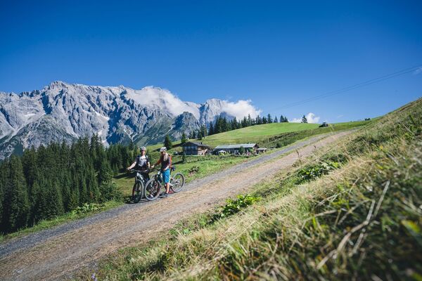
A leisurely e-bike tour along the goods paths from Dienten to the mountain farms and back to the village. Ideal for family excursions by bike. Enjoy nature and experience the everyday life of the Dienten farmers.
- Difficulty
-
easy
- Rating
-
- Starting point
-
Ski center Dienten
- Route
-
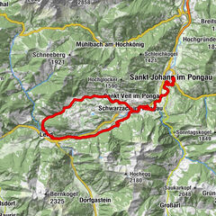
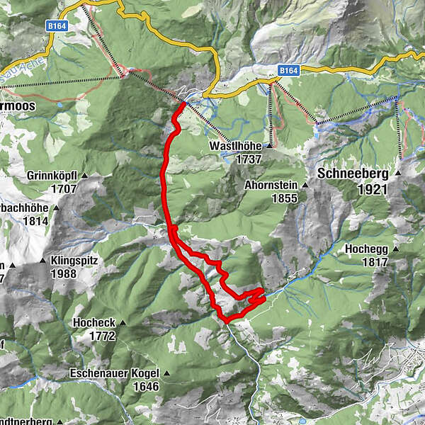
Dienten am Hochkönig0.3 kmSchattberg4.2 kmSonnberg4.4 kmSonnberg10.5 kmSchattberg10.7 kmFischerstüberl11.6 kmDienten am Hochkönig14.7 km
- Best season
-
JanFebMarAprMayJunJulAugSepOctNovDec
- Description
-
From the village of Dienten/Skizentrum (MTB, e-bike rental and petrol station), follow the main road out of the valley until you reach the turn-off for the "Lindl" or Fischerstüberl (closed!) - approx. 3km. Follow the path past several farms (approx. 2.5 km uphill) until you reach a fork in the road. When you reach a fork in the road (Güterweg Schwarzenbach), turn right in the direction of Dientner Landesstraße/Sägewerk Feroli. Once at the Feroli sawmill, we follow the Dientner Landesstraße (turn right) back towards the village of Dienten/ski centre, climbing slightly uphill (approx. 5.5 km).
The tour can also be comfortably started from the other side (Feroli sawmill) - Directions
-
From the village of Dienten/Skizentrum (MTB, e-bike rental and petrol station), follow the main road out of the valley until you reach the turn-off for the "Lindl" or Fischerstüberl (closed) - approx. 3km. Follow the path past several farms (approx. 2.5 km uphill) until you reach a fork in the road. When you reach a fork in the road (Güterweg Schwarzenbach), turn right in the direction of Dientner Landesstraße/Sägewerk Feroli. Once at the Feroli sawmill, we follow the Dientner Landesstraße (turn right) back towards the village of Dienten/ski centre, climbing slightly uphill (approx. 5.5 km).
The tour can also be comfortably started from the other side (Feroli sawmill). - Highest point
- 1,110 m
- Endpoint
-
Ski center Dienten
- Height profile
-

- Equipment
-
Controlled bike equipment with helmet
Sunglasses
Sun protection
Rain protection
Drinks and a snack
Necessary medication
First aid kit
Bike map - Safety instructions
-
Fair play!
Drive only on marked paths! Close all gates, barriers and pasture gates! Observe the road traffic regulations! Overtake only at walking pace! Behave respectfully towards other nature users! and the forestry and hunting staff! Be considerate of animals! Do not leave waste in nature! Act responsibly! Check the weather forecast. Fog and bad weather can come surprisingly quickly.Emergency numbers: Alpine emergency call: 140
International emergency call: 122 - Tips
-
You can also make the round nicely from the other side.
- Additional information
- Directions
-
Coming from Salzburg: Take the A10 freeway to the Bischofshofen exit, then take the B311 in the direction of Bischofshofen. Follow the Hochkönig Bundesstraße/B164 to Mühlbach and further to Dienten.
Coming from Innsbruck/ Kufstein: On the Loferer Straße/B178 in the direction of St. Johann i.T., then on the Hochkönig Bundesstraße/B164 via Saalfelden and Maria Alm to Dienten or to the Filzensattel.
A valid vignette is required to use the Austrian motorway and motorway network. It is also compulsory to carry a first-aid kit, warning triangle and high-visibility waistcoat. Further information can be found under Asfinag. - Public transportation
- Parking
-
Free parking at the Dienten ski center


- Author
-
The tour e-Bike Tour - Sonnberg Round is used by outdooractive.com provided.


General info
-
Hochkönig
168
-
Dienten am Hochkönig
50