- Brief description
-
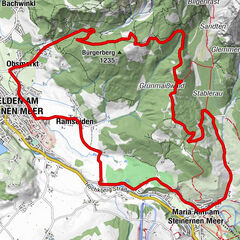
Medium-difficulty mountain bike trail from the village of Dienten to the Pichlalm.
- Difficulty
-
medium
- Rating
-
- Starting point
-
Ski centre Dienten
- Route
-
Dienten am Hochkönig0.0 kmHöfl-Zachhof0.6 kmMittereggalm3.1 kmPichl Alm3.8 kmHöfl-Zachhof6.9 kmDienten am Hochkönig7.6 km
- Best season
-
JanFebMarAprMayJunJulAugSepOctNovDec
- Description
-
From the Dienten Ski Centre (MTB, eBike rental and eBike filling station) we turn right onto the Dientner Landesstraße and follow the road until we reach the roundabout, here we continue in the direction of Filzensattel/Saalfelden (B164). After about 1.5 km of steep ascent, we turn right onto Güterweg No. 67, which leads us in the direction of Rohrmoosgut. Shortly before the farm, a rough gravel road begins on the left side, which leads to the Pichlalm. The rough gravel makes the short ascent to the hut difficult. The way back is via the same route and also leads us back to our starting point.
- Directions
-
Simply follow the signs "DI 02 Pichlalm-Tour"
From the Dienten ski centre (MTB, eBike hire and eBike filling station), turn right onto the Dientner Landesstraße and follow the road until you reach the roundabout, where you continue in the direction of Filzensattel/Saalfelden (B164). After approx. 1.5 km of steep ascent, we turn right onto the goods roadwhich leads us in the direction of Rohrmoosgut. Shortly before the farm, a rough gravel road begins on the left-hand side, which leads to the Pichlalm. The rough gravel makes the short ascent to the hut more difficult. The way back follows the same route and takes us back to our starting point. - Highest point
- 1,423 m
- Endpoint
-
Ski centre Dienten
- Height profile
-

- Equipment
-
Controlled bike equipment with helmet
Sunglasses
Sun protection
Rain protection
Drinks and a snack
Necessary medication
First aid kit
Bike map - Safety instructions
-
Fair play!
Drive only on marked paths! Close all gates, barriers and pasture gates! Observe the road traffic regulations! Overtake only at walking pace! Behave respectfully towards other nature users! and the forestry and hunting staff! Be considerate of animals! Do not leave waste in nature! Act responsibly! Check the weather forecast. Fog and bad weather can come surprisingly quickly.Emergency numbers: Alpine emergency call: 140
International emergency call: 122 - Tips
-
Stop at the Pichlalm at the foot of the Lausköpfe. Thursday is "Bladltag". Marmot colony nearby.
- Additional information
- Directions
-
Coming from Salzburg: Take the A10 freeway to the Bischofshofen exit, then take the B311 in the direction of Bischofshofen. Follow the Hochkönig Bundesstraße/B164 to Mühlbach and further to Dienten.
Coming from Innsbruck/ Kufstein: On the Loferer Straße/B178 in the direction of St. Johann i.T., then on the Hochkönig Bundesstraße/B164 via Saalfelden and Maria Alm to Dienten or to the Filzensattel.
A valid vignette is required to use the Austrian motorway and motorway network. It is also compulsory to carry a first-aid kit, warning triangle and high-visibility waistcoat. Further information can be found under Asfinag. - Public transportation
- Parking
-
Free parking at the Dienten Ski Centre


- Author
-
The tour MTB-Tour Pichlalm-Round (Tour 2) is used by outdooractive.com provided.


General info
-
Hochkönig
357
-
Dienten am Hochkönig
88