- Brief description
-
This is the connection to the neighboring village Goldegg with further attractive mountain bike trails.
- Difficulty
-
easy
- Rating
-
- Starting point
-
Ski centre Dienten
- Route
-
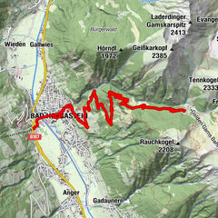
Dienten am Hochkönig0.3 kmFischerstüberl3.3 kmSchattberg4.0 kmSonnberg4.2 kmOberdorfkapelle9.0 kmBoden10.7 km
- Best season
-
JanFebMarAprMayJunJulAugSepOctNovDec
- Description
-
From the village of Dienten, follow the Dientner Landesstrasse (L216) out of the valley towards Lend until you pass by the Sägewerk Feroli sawmill. Continue following the road, and after ca. 500m, a tractor path called the “Wallreitweg” starts on the left side of the street. This path leads somewhat steeply uphill at first but then evens out. The path is used by residents and tractors/agricultural machinery. Cars and trucks are generally not allowed. On the last stretch of the forest path, you will reach the Hinterbühel farm, from which a paved road leads down the mountain to the Unterdorf/ Oberdorf farms. The road branches off here and leads around the lake. The return trip follows the same route.
- Directions
-
From the Dienten Ski Centre (MTB, eBike rental and eBike filling station), follow the Dientner Landesstraße (L216) in the direction of Lend out of the valley to the Feroli sawmill. From there we follow the course of the road for about another 500 m. Here a tractor path called "Wallreitweg" begins on the left side of the road. This starts off a little steeper uphill, but the route changes again and again into a straight line. The path is used by local residents and tractors/agricultural machinery. When you reach the last section of the field path, you will reach the Hinterbühel farm, from here an asphalt road leads down the hill to the Unterdorf/Oberdorf farms. Here the road branches off, which leads around the lake. The way back is via the same route.
- Highest point
- 1,054 m
- Endpoint
-
Ski centre Dienten
- Height profile
-

- Equipment
-
Controlled bike equipment with helmet
Sunglasses
Sun protection
Rain protection
Drinks and a snack
Necessary medication
First aid kit
Bike map - Safety instructions
-
Fair play!
Drive only on marked paths! Close all gates, barriers and pasture gates! Observe the road traffic regulations! Overtake only at walking pace! Behave respectfully towards other nature users! and the forestry and hunting staff! Be considerate of animals! Do not leave waste in nature! Act responsibly! Check the weather forecast. Fog and bad weather can come surprisingly quickly.Emergency numbers: Alpine emergency call: 140
International emergency call: 122 - Tips
-
Taking a dip in the Böndlsee to cool off is a HIT.
ATTENTION: the connecting path is wide and easy to drive on, but very sloping in some places. Expect oncoming traffic from agricultural vehicles. - Additional information
- Directions
-
Coming from Salzburg: Take the A10 freeway to the Bischofshofen exit, then take the B311 in the direction of Bischofshofen. Follow the Hochkönig Bundesstraße/B164 to Mühlbach and further to Dienten.
Coming from Innsbruck/ Kufstein: On the Loferer Straße/B178 in the direction of St. Johann i.T., then on the Hochkönig Bundesstraße/B164 via Saalfelden and Maria Alm to Dienten or to the Filzensattel.
A valid vignette is required to use the Austrian motorway and motorway network. It is also compulsory to carry a first-aid kit, warning triangle and high-visibility waistcoat. Further information can be found under Asfinag. - Public transportation
- Parking
-
Free parking at the Dienten ski centre or at the Wallreitweg junction


- Author
-
The tour MTB Tour - Böndlsee round trip is used by outdooractive.com provided.


General info
-
Hochkönig
357
-
Dienten am Hochkönig
88