Salzburger Almenweg - Stage 01: Werfen – Arthurhaus


- Brief description
-
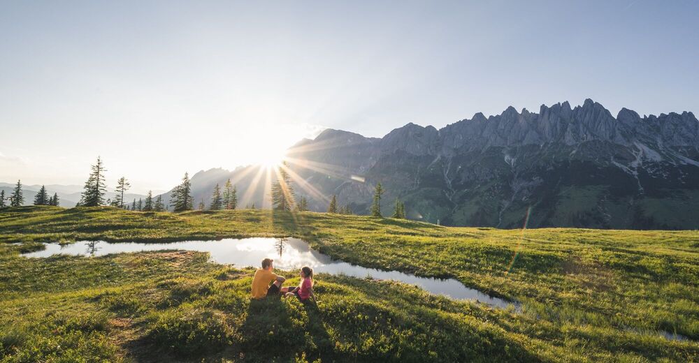
From the Salzach Valley to the Hochkönig sun kingdom
- Difficulty
-
medium
- Rating
-
- Starting point
-
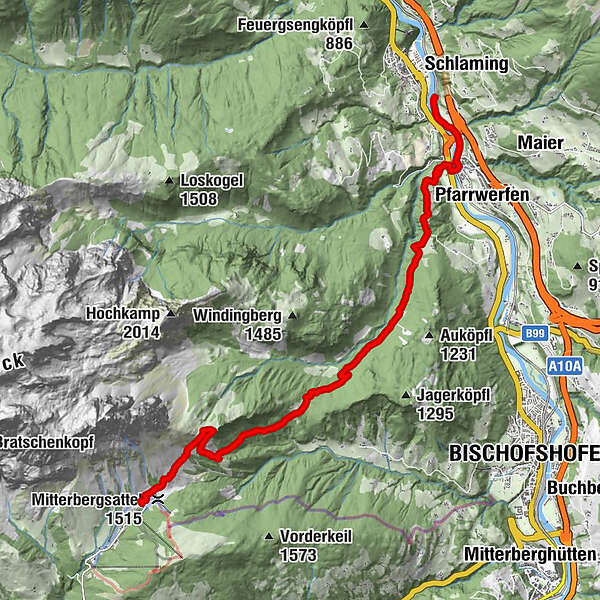
ÖBB bus stop Werfen (525 m)
- Route
-
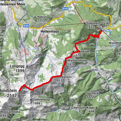
WerfenReitsamerhof1.8 kmGrünmaiß8.3 kmMitterfeldalm10.9 kmArthurhaus12.8 kmSennerei Schweizerhütte12.8 km
- Best season
-
JanFebMarAprMayJunJulAugSepOctNovDec
- Description
-
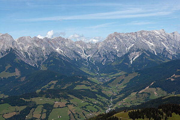
Werfen marks the official start and end point of the Salzburger Almenweg, where after 25 stages, the circuit finishes here. Those arriving in Werfen will find themselves in one of the most historic valleys in Salzburg. Pass Lueg marks the border between the foothills of the Alps and the "Inner Mountains". Here, the Salzach Valley has always been considered a bottleneck, both for the rebellious peasants, for the Napoleonic troops and for Alpine crossers of all kinds. Hohenwerfen Castle was built high on a hill here as its defensive bulwark.
The name Werfen is derived from the Middle High German "werve" and means as much as vortex. Whether this refers to the windswept peaks or the Salzach river with its shoals remains uncertain. Pfarrwerfen was built as early as 1075, at the same time as the foundation stone of the castle was laid. A visit to the parish church is highly recommended, as well as the open-air experience "7 Mills", which offers an insight into the historical milling trade. The first stage leads from the shadow of the Tennen and Hagen Mountains up to the sunny flanks of the legendary Hochkönig.
Off the beaten track
With the Hohenwerfen Adventure Castle and the Ice Caves, two of Salzburg's greatest sights are in the immediate vicinity of Pfarrwerfen. If you can spare some time, you should definitely not miss these excursion destinations. And not forgetting the FIS State Skiing Museum in Werfenweng, the "Sound of Music" trail in Werfen and the Paul Außerleitner ski jump in Bischofshofen are also worth a visit.
Alpine Trail Peak Tour
If this day stage is not enough for you, you can head from the Arthurhaus to the 1,782-metre-high wedge where you will be rewarded with a magnificent view.
- Directions
-
The starting point of the first stage of the Salzburger Almenweg is the ÖBB stop in Werfen. First, the Salzburger Almenweg leads on a path to the south directly along the banks of the Salzach for about 2 km to Pfarrwerfen.
Directly in front of the Pfarrwerfen train station, the Salzach is crossed over a larger bridge and the country inn "Reitsamerhof" is reached. Directly behind it, a steep access road turns left, which leads to Schwabegg and from which a magnificent view of the Tennengebirge opens up.
About 300 m later, keep to the right at a fork in the road (path no. 15), after another 400 m turn right again (path no. 15) and thus reach an easy, 4-kilometre-long section over a forest road without significant ascents through the shady Hölln valley past the former Hölln inn.
Shortly before the idyllic hunting lodge, trail no. 16 branches off to the left up to the Grünmaißalm. A few hundred meters before you leave the forest behind you and there is a beautiful view of the imposing Werfener Hochthron in the Tennengebirge on the opposite side of the Salzach Valley. The forest road ends at the alpine pasture and the hike continues on a path that starts a little above.
After about 1 kilometre on the trail, you reach another forest road, which you follow for about 100 metres in a westerly direction until another path branches off on the right. This leads first steeper, then very leisurely to the Stegalm, in front of which the forest thins out.
From the crossroads at the Stegalm, it is still about 270 metres in altitude and less than an hour's walk to the wonderfully situated and managed Mitterfeldalm at 1,695 metres above sea level at the foot of the Hochkönig.
After a refreshment, it is not far to today's stage destination, the Arthurhaus: it can be reached via a hiking trail (no. 430) below the southern slopes of the Mandlwand in a good half an hour's walk.
However, you will not spend the night at the Arthurhaus, but in Mühlbach am Hochkönig you can descend directly to the centre of Mühlbach am Hochkönig via the Erzweg in another 2 hours (5.9 kilometers, 68 meters of ascent and 711 meters of descent) or easily take the Hochkönig hiking bus from the Arthurhaus down to the town centre. From the town centre, you can reach tomorrow's stage start, the Arthurhaus, the next day via the Erzweg Trail or with the hiking bus again.
If you descend on foot: from the Arthurhaus, always following path no. 85 past the quarries of prehistoric copper mining, down to the tunnels of modern copper mining and former processing plants. At the Riedingtal valley, follow a small road for about 50 m before path no. 85 turns left again. Now it goes on a path through the romantic Barbara Gorge. This leads below the Ruperti Stollen into the old Mitterbergstraße - follow it downhill and turn left over a brick arched bridge through the Hochwald to Viererwasch. Via the route of the old light railway, trail no. 84a leads to the Kniegut and on to the centre of Mühlbach.
Variant 1a from the Grünmaißalm:
Immediately before the Grünmaißalm, the turn-off can be taken to the right. This trail branches off to the left after about one kilometre and becomes steeper. It crosses a forest road and leads past the dilapidated Steinalm up to the Mitterfeldalm. This variant is slightly shorter and sharper.
Alternative stage 1b starting in Bischofshofen:
If you arrive by public transport, you can also start the Salzburger Almenweg in Bischofshofen instead of in Pfarrwerfen. The ÖBB train station in Bischofshofen is an important transport hub on the Salzburg, Innsbruck, Graz (Klagenfurt) main line. From the station, follow the signs for "Paul Außerleitner Ski Jump". At the sports facility, there is also the possibility to park your car long-term in the Gainfeld car park. Please leave the "Alpine Trail parking meter" from the brochure in your parked car!
The trail leads past the ski jump and the visitor centre "Erz der Alpen UNESCO Global Geopark" to the west, where Kematenalm, Loimair Alm and Stegalm are all signposted. The Mitterfeldalm can be reached in about three hours on foot. The variant via Grünmaißalm and Steinalm (see variant 1a) is also possible. The descent to the Arthurhaus takes place as described above.
Refreshment and accommodation options
Mitterfeldalm (1,690 m), (after approx. 4.75 hours) end of May to the end of October, T. +43 664 6438077 Alpine summer hut / refresh. + accomm.
Schweizerhütte (1,502 m), (after approx. 5 hours) mid-May to the end of October (Wed – Sun), T. +43 6467 7207 Alpine summer hut / refresh.
Arthurhaus (1,500 m), (after approx. 5 hours) mid-May to the end of October, T. +43 6467 7207 refresh. + accomm.
Numerous places to stop for refreshments an overnight stays in Mühlbach, www.hochkoenig.at
Accomodation Partner Salzburger Almenweg Information and Booking Centre powered by Trail Angels: Hotel Alpenrose, more information: http://www.hotel-alpenrose.co.at/ , T. +43 6467 7262
- Highest point
- 1,670 m
- Endpoint
-
Arthurhaus (1.502 m), Mühlbach am Hochkönig
- Height profile
-

- Equipment
-
Here you will find everything about the right hiking boots, the perfect equipment and the right walking technique.
- Safety instructions
- Tips
-
If you want to visit Hohenwerfen Castle or the Ice Caves, you can take the W3 shared taxi. The shared taxi picks up guests (after pre-booking) at their desired address within the three towns of Werfen, Pfarrwerfen and Werfenweng and takes them to a fixed point (town centres or train stations) and back again. There is also a connection to Bischofshofen train station.
Tel.: +43 664 1266700
- Additional information
- Public transportation
- Parking
-
For those arriving by car, you can park at the ÖBB bus stop "Werfen". Please leave the "Salzburger Almenweg parking disc" from the brochure in your parked car!


- Author
-
Salzburger AlmenwegThe tour Salzburger Almenweg - Stage 01: Werfen – Arthurhaus is used by outdooractive.com provided.


General info
-
Tennengebirge - Hagengebirge
2111
-
Pfarrwerfen
325