Salzburger Almenweg - Stage 11: Hüttschlag - Tappenkarseehütte


- Brief description
-
An ice-cold lake, rare flowers and a scary legend
- Difficulty
-
medium
- Rating
-
- Starting point
-
Hüttschlag (1,030 m)
- Route
-
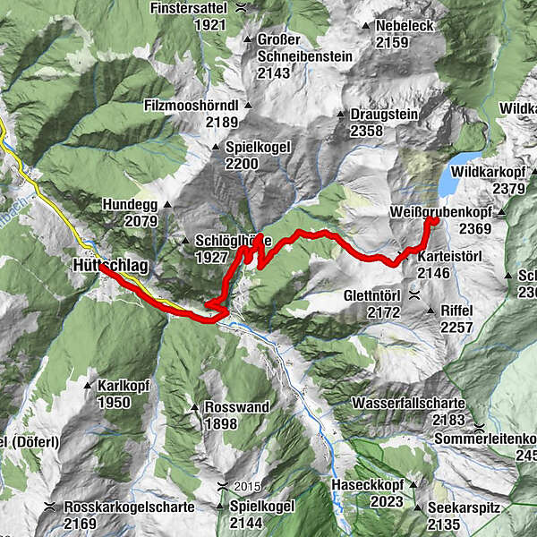
Hotel Almrösl0.1 kmHüttenwirt0.1 kmHüttschlag0.2 kmPfarrkirche Hüttschlag0.3 kmSchrambach1.2 kmWolfau1.6 kmGruberwirt1.7 kmKarteiskapelle2.6 kmKarteis2.8 kmKarteistörl (2,146 m)10.2 kmTappenkarseehütte11.6 km
- Best season
-
JanFebMarAprMayJunJulAugSepOctNovDec
- Description
-
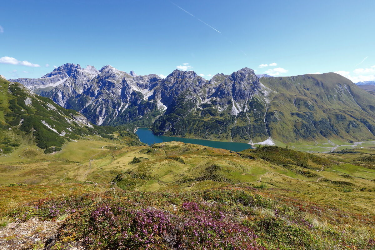
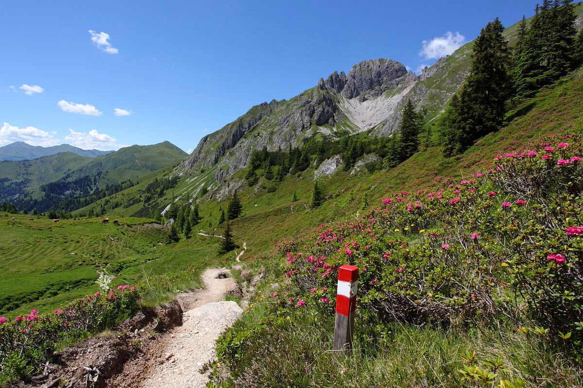
Stage 11 leads from Hüttschlag across a quite challenging ascent over flower-strewn meadows to the Karteistörl and the largest mountain lake in the Eastern Alps in about 5 hours. Aber Achtung: Heute gibt es bis zum Etappenziel keine Einkehrmöglichkeiten auf dem Weg, daher unbedingt Jause einpacken! Zudem zählt die Etappe mit 1.264 Höhenmetern im Anstieg zu den längsten auf dem gesamten Almenweg. Lake Tappenkarsee is located at about 1,800 metres above sea level and we are sure that when you see it for the first time, shortly after the Karteistörl, you will stop and be overwhelmed. It is thus no wonder that this stage is for many people one of the most beautiful sections on the Salzburger Almenweg. The lake is nestled between the Grossarler Grasbergen and the rocky peaks of the Radstädter Tauern in Kleinarl and, according to legend, is home to a voracious monster.
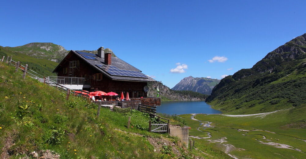
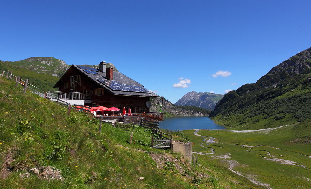
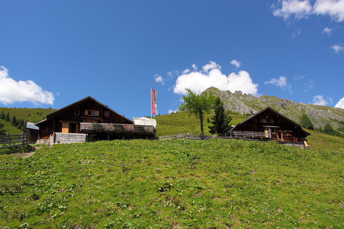
You will spend the night at the Tappenkarseehütte, which is located slightly above the lake and offers a wonderful view: From here make sure you keep an eye on the lakeshore, especially when fog wafts over the cold water, as who knows when the monster will next appear and what it has in mind.
Along the trail
The mighty, 2,358 metre high Draugstein with its wide flanks is one of the few limestone mountains in the Grossarltal that bring out a completely unique vegetation here. Already on the ascent to the Karteistörl, flower lovers can look forward to a lush splendour of colours and flowers. Countless shades of green mix with the strong pink of the alpine roses, the dark purple of the so-called “Knabenkräuter” (a native orchid species), the yellow of arnica and the white of the fluffy woolly grass.
Alpine Trail History
Would you like a little bedtime story? Well, then we want to tell you about the Lindwurm (dragon) in Lake Tappenkarsee. This legend is a cultural asset in SalzburgerLand and, according to the legend, a voracious Lindwurm once caused a lot of terror around the lake, which is up to fifty metres deep. He devoured everything that moved on the shore and so some men decided to kill the monster. However, the plan failed and full of the desire for revenge, the Lindwurm has been sitting at the bottom of the lake since then and gnawing at the rock that borders Lake Tappenkarsee to the Kleinarl Valley. When he finally succeeds in breaking through the wall, the entire valley will sink under the mass of water right up to Wagrain. According to another legend, Lake Tappenkarsee is said to be connected underground with Lake Schuhflickersee north of the two Schuhflicker valleys further along between the Grossarl and Gastein valleys. There, it is said that a cartwheel was found, which had previously fallen into Lake Tappenkarsee.
Alpine Trail Refreshment
"Dreifärbiger Kaiserschmarrn" (triple coloured) is served at the Tappenkarseehütte. This colourful variant of the classic pastry is tastily complemented with apple sauce, cranberry and blackberry jam. The blackberries (also known as blueberries or cranberries) may of course also be eaten along the trail. Usually at this altitude they are ripe in late August / mid-September.
- Directions
-
From the starting point at the hiking starting point in the mountaineering village® of Hüttschlag, it is best to follow the markings of the "Chapel Hiking Trail" parallel above the main road into the valley. On the way, it is recommended to take a look at the Christophorus Chapel in Wolfau and the Karteis Chapel with its magnificent Madonna in Karteis: The Christophorus Chapel is just above the path - shortly afterwards you either hike along the slightly higher hiking trail or along the main road for a short distance, before leaving the main road again at the Karteiskapelle and crossing the Grossarlbach. Shortly before the road forks into Karteis about 200 metres behind the chapel, a footpath (no. 55a) branches off to the left between the houses to Oberstein, an old farmstead with a beautiful view of the valley. Following this footpath uphill, turn right below Mühlegg (path no. 55a) in the direction of the Hallmoosalm and continue on the other side of the ditch on a goods road steadily uphill.
At the first car park past the Hallmoosalm, at the second car park – at the fork in the road with the two barriers – follow trail no. 53 on the right and the signs to the Karteisalm.
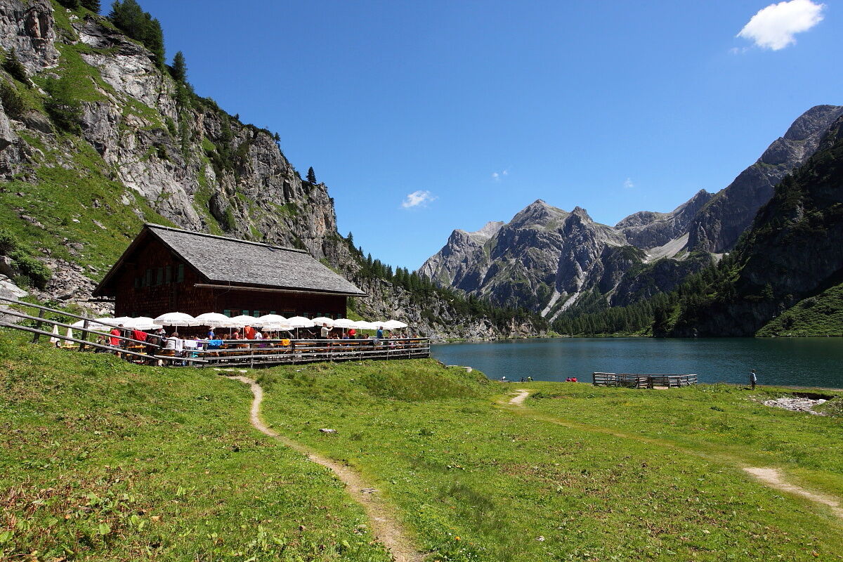
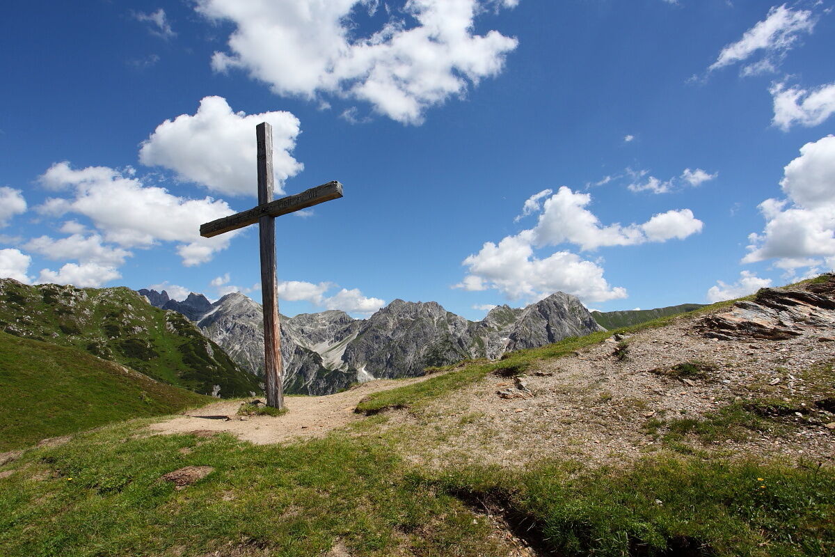
After about 10 minutes of walking, a farm road (no. 53) branches off to the left from the forest road to the Karteisalm, which becomes narrower and narrower and finally leads to an alpine path. From the alpine pasture, the trail leads through a wide cirque to the Karteistörl (2,145 m), from where a 15-minute detour to the Kreuzeck (2,204 m) is possible and extremely worthwhile. From the Karteistörl, hiking trail no. 721, which runs downhill to the left, leads in about 40 minutes to today's stage destination, the Tappenkarseehütte (ÖAV section Edelweiss). The cabin is in a fantastic location near the lake of the same name.
Note: A nice variant incorporates the 2,204-metre-high Kreuzeck as a round trip into today's stage. For about 30 minutes after the Karteisalm, follow trail no. 53a to the right to the west ridge of the Kreuzeck and over it to the summit. From here, take the north ridge (path no. 53) down to the Karteistörl, where you meet the official route of the Salzburger Almenweg again. The advantage of this small "detour" is the breathtaking panoramic view of Glingspitz (2,433 m), Keeskogel (2,884 m) and the Hohe Tauern in the southwest as well as Mosermandl (2,680 m), Faulkogel (2,654 m) and Weißeck (2,711 m) in the east. In addition, even in summer, there is usually a fine breeze blowing on the top of the ridge, while in the wide valley basin the heat is more likely.
Refreshment and accommodation options
Tappenkarseehütte (1,825 m), (after approx. 5 hours) June to end of September, T. +43 676 3409923 refresh./ accomm.
Tappenkarseealm (1,768 m), (after approx. 5.25 hours, is located just below the Tappenkarseehütte) June to end of September, T. +43 676 3409923 refresh.
- Highest point
- 2,136 m
- Endpoint
-
Tappenkarseehütte (1,825 m), Kleinarl
- Height profile
-

- Safety instructions
- Tips
-
The national park experience exhibition "Auf der Alm - zwischen Himmel und Erde" (On the Alm - between Heaven and Earth) at the end of the Hüttschlag Valley deals with the special features of the alpine landscape and alpine life, and complements well the "Secrets of the Mountain Forest" exhibition. It’s open daily from mid-May to the end of October, from 10 a.m. to 5 p.m.
- Additional information
- Public transportation
- Parking
-
If you arrive by car, you can park it free of charge in Hüttschlag in the town centre parking lot near the Schappachkapelle for several days. Please leave the "Salzburger Almenweg parking disc" from the brochure in your parked car!
- Author
-
Salzburger AlmenwegThe tour Salzburger Almenweg - Stage 11: Hüttschlag - Tappenkarseehütte is used by outdooractive.com provided.


General info
-
Katschberg Lieser-Maltatal
2556
-
Großarltal
2151
-
Hüttschlag
843