- Brief description
-
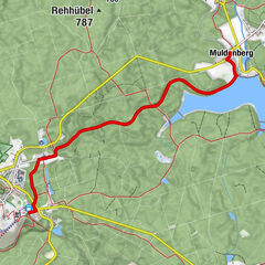
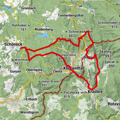
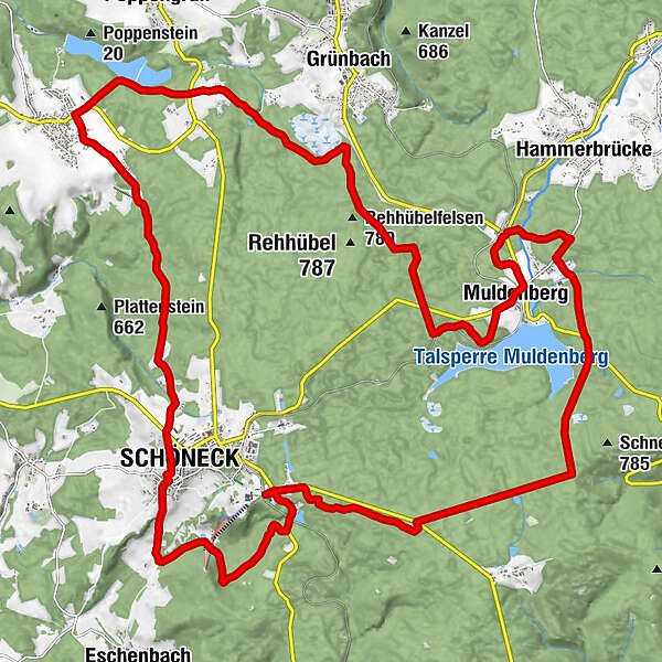
The tour leads throuh woods, from Schöneck via Muldenberg to Werda and back to Schöneck.
- Difficulty
-
medium
- Rating
-
- Starting point
-
Route entry Bikewelt Schöneck - roundabout Kärrnerstraße
- Route
-
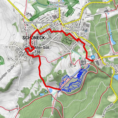
Tannenhaus0.4 kmMuldenberg11.4 kmBergschlößchen11.5 kmWerda21.6 kmFreizeitpark Haselmühle26.6 kmSchöneck27.5 kmAlter Söll (736 m)27.6 kmEv.-Luth. Kirche "St.Georg"27.8 km
- Best season
-
JanFebMarAprMayJunJulAugSepOctNovDec
- Description
-
The panorama tour starts after the roundabout at the IFA holiday park and leads initially over the Kirchsteig, then along the forest paths past the Muldenberg dam. It is definitely worth taking a detour to the accessible dam wall or taking a break at one of the three restaurants. We follow the path through the village and reach the Werda dam on dreamy forest paths. We also pass Werda and drive back to Schöneck. On the outskirts, the Haselmühle leisure area invites you to take a short break. The road continues, past the market square and the church, from Schöneck towards Eschenbach. At the "Bockmühlen" we turn left into the forest path and get to the valley station of the ski lifts, cross the slope and follow the path further up to the IFA holiday park. This tour ends with the great panoramic view over the Vogtland.
- Directions
-
Our tour starts at the Bikewelt Schöneck. From there we drive eastwards on Klingenthaler Straße, then we turn right into the forest. The next 2 km we are on a gravel path parallel to the road, then we cross it and choose the long straight to the northeast.
We ignore smaller junctions and only turn left at the second slightly larger intersection. This way we get to the Muldenberg dam. After a short stretch along the road, it goes back into the forest. We cross the Silberbach and make a loop through the Muldenberg nature reserve. The "Untere Floßgraben" then leads us to the center of the village; behind the last houses we leave the main street again to the left.
After a little loop to the south we come to the train tracks, which we follow for a moment. Then a longer straight takes us west. We now turn right into the "Heuweg", cross the street on it and keep straight ahead at the next junction. So we finally reach "Siehdichfürer Straße", where we turn left and reach the Geigenbach barrier via Neudorf.
Our next stop is Werda, after crossing the town center we choose a shady forest path that takes back to Schöneck. If you still have strength in your legs, you can take the detour to the south, which leads through the FFH area in Tiefen Grund.
- Highest point
- 798 m
- Endpoint
-
Bikestation Bikewelt Schöneck (parking garage)
- Height profile
-
 © outdooractive.com
 - Equipment
-
Always ride with appropriate protective clothing and a bike that is suitable for the terrain.
- Additional information
- Directions
-
Leave the A72 at the Plauen-Süd exit and follow the B92 towards Oelsnitz. After about 7 km leave the B92 in the direction of Schöneck / Klingenthal. After the towns of Görnitz, Tirschendorf, Willitzgrün and Arnoldsgrün you have reached Schöneck.
- Public transportation
-
With the RB 1 line of the Vogtlandbahn you can easily reach Schöneck (IFA Ferienpark stop) by train. In the hiking and cross-country ski run house you will find lockers, changing rooms and toilets. With the "TaktBUS22" bus from Muldenberg, the "Bus90" from Plauen and Oelsnitz, or the "TaktBUS93" from Bad Elster, you can use the bus stop at the IFA Ferienpark and board the tour directly.
- Parking
-
Parking garage at the IFA holiday park, there are also 12 mobile home parking spaces
- Author
-
The tour MTB route 7 - Vogtland panorama tour is used by outdooractive.com provided.