© Harz: Magische Gebirgswelt - moobix
- Brief description
-
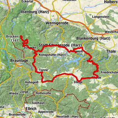
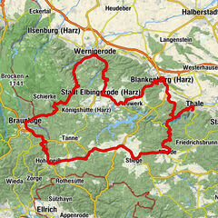
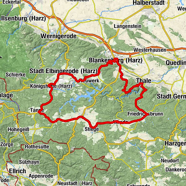
Thale - Friedrichsbrunn - Allrode - Hasselfelde - Tanne - Elbingerode - Rübeland - Blankenburg - Wienrode - Thale
- Difficulty
-
medium
- Rating
-
- Route
-
Thale Hauptbahnhof0.1 kmThale (156 m)0.2 kmUntrüborn9.4 kmFriedrichsbrunn9.5 kmHanolds Bräustübl9.8 kmBonhoeffer-Kirche9.8 kmZur Unterklippe10.2 kmAllrode15.3 kmWalze21.2 kmHüttenberg (511 m)23.1 kmAlte Straßenmeisterei24.7 kmSt.-Antonius-Kirche25.5 kmStadt Hasselfelde25.6 kmLotus25.6 kmZur Krone25.6 kmDruidenstein30.6 kmTrautenstein30.7 kmHeringstal35.3 kmTanne35.8 kmSpielbachsmühle41.7 kmKönigshof42.1 kmKönigshütte (Harz)42.5 kmRothehütte43.3 kmStadt Elbingerode (Harz) (458 m)48.2 kmNeuapostolische Kirche48.4 kmRübeland51.5 kmZur grünen Eiche51.5 kmGasthaus Bodetal51.5 kmRübeland (Harz)51.6 kmTannengrund51.7 kmChristuskirche51.9 kmKreuztal53.4 kmHüttenrode56.8 kmHarzer Krug57.2 kmZiegenkopf (406 m)60.5 kmBlankenburg (Harz) (288 m)63.2 kmLutherkirche64.7 kmRestaurant "Harzer Hexenkessel"66.9 kmCattenstedt67.0 kmMuehlenkrug68.2 kmWienrode68.4 kmBlauer Bruch71.2 kmThale (156 m)78.7 km
- Best season
-
JanFebMarAprMayJunJulAugSepOctNovDec
- Highest point
- 566 m
- Endpoint
-
Bodetal-Information Thale, Bahnhofstraße 1, 06502 Thale
- Height profile
-
 © outdooractive.com
- Author
-
The tour Oberharzer Runde is used by outdooractive.com provided.
GPS Downloads


General info
Refreshment stop
Flora
Other tours in the regions
-
Der Harz/ Sachsen-Anhalt
29
-
Bodetal
22
-
Wendefurth
14