Die Gehöfte-Tour

Logo Die Gehöfte-Tour
Tour data
19.08km
249 - 458m
Distance
247hm
255hm
Ascent
03:00h
 
Duration
Brief description

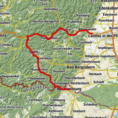
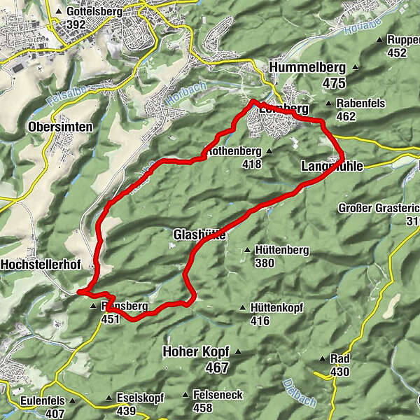
Das Auf und Ab der Tour vereint Wald, Wiesen, romantische Täler und aussichtsreiche Höhen.

Difficulty
medium
Rating
Technique
Fitness
Landscape
Experience
Route
Lemberg
0.0 km
Rodalberhof
4.8 km
Kettrichhof
6.8 km
Glashütte
12.5 km
Langmühle
16.1 km
Lemberg
18.5 km
Best season
Jan
Feb
Mar
Apr
May
Jun
Jul
Aug
Sep
Oct
Nov
Dec
Highest point
458 m
Endpoint

Wohnmobilparkplatz an der Weiherstr.

Height profile
© outdooractive.com

Author
The tour Die Gehöfte-Tour is used by outdooractive.com provided.

Overall rating

5

0

%

4

0

%

3

0

%

2

0

%

1

0

%

Error
An error has occurred. Please try again.
Thank you for your review

Rating has been deleted

GPS Downloads
  • GPX GPS Exchange Format (XML)
  • KML Google Earth, Google Maps
QR Download Codes for Mobile Phones

General info

Refreshment stop
Insider tip
Flora
Other tours in the regions

Popular tours in the area

Hornbach-Fleckenstein Cycle Trail

medium Cycling
63.18km | 692hm | 05:00h

Freundschafts-Tour

difficult Cycling
28.28km | 316hm | 03:45h

Raubritter-Tour

difficult Cycling
39.52km | 447hm | 06:00h