© Heidiland Tourismus - Bergbahnen Flumserberg

© Heidiland Tourismus - Bergbahnen Flumserberg

© Heidiland Tourismus - Bergbahnen Flumserberg

© Heidiland Tourismus - Bergbahnen Flumserberg

© Heidiland Tourismus - Bergbahnen Flumserberg

© Heidiland Tourismus - Bergbahnen Flumserberg

© Heidiland Tourismus - Bergbahnen Flumserberg

© Heidiland Tourismus - Bergbahnen Flumserberg

© Heidiland Tourismus - Bergbahnen Flumserberg

© Heidiland Tourismus - Bergbahnen Flumserberg

- Brief description
-
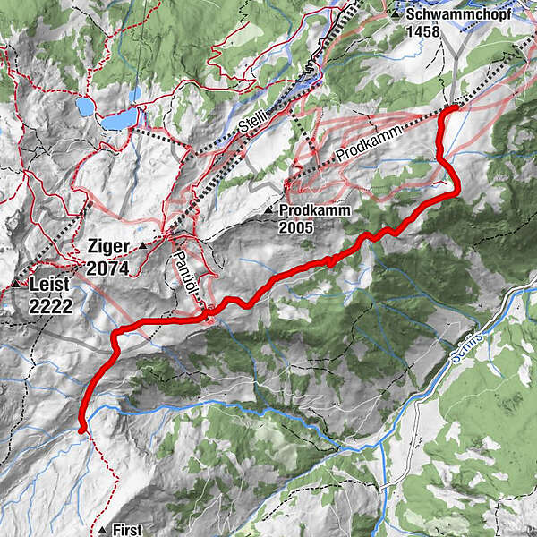
Enjoy the hike with a wonderful view of the Spitzmeilen and the surrounding mountains.
- Difficulty
-
medium
- Rating
-
- Route
-
Prodalp0.0 kmPanüöl3.9 kmAlp Fursch6.0 kmFursch6.0 km
- Best season
-
JanFebMarAprMayJunJulAugSepOctNovDec
- Highest point
- 1,835 m
- Endpoint
-
Fursch, Flumserberg
- Height profile
-
 © outdooractive.com


-

-
AuthorThe tour Prodalp - Panüöl - Fursch is used by outdooractive.com provided.
GPS Downloads


General info
Refreshment stop
A lot of view
Other tours in the regions
-
Heidiland
2200
-
Flumserberg und Umgebung
898
-
Flumserberg
236