
- Difficulty
-
medium
- Rating
-
- Starting point
-
Wellnesshotel Golf Panorama, Lipperswil
- Route
-
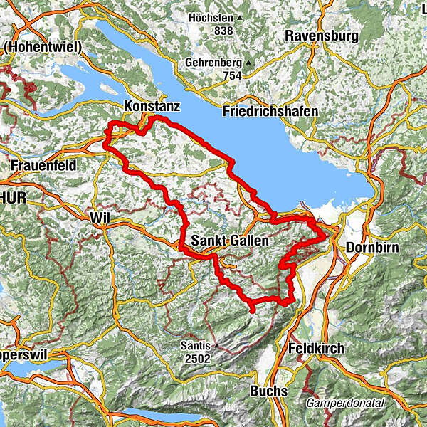
Lion d’orHattenhausen0.4 kmHefenhausen0.8 kmSchäfli1.0 kmWagerswil1.9 kmSchulhaus Engwang2.9 kmEngwang3.1 kmGrubmühle3.6 kmBirkenhof4.6 kmMärstetten5.0 kmRestaurant Sonne5.1 kmHalden6.7 kmWeinberg7.0 kmSchnellberg7.1 kmWeinfelden9.6 kmIm Sonnenwinkel9.6 kmMartin's11.4 kmAeuli14.0 kmBürglen14.7 kmSonne Au18.2 kmSchönenberg an der Thur19.6 kmZentrum19.8 kmKradolf (457 m)20.0 kmKradolf20.1 kmMittel Tellen22.2 kmHeidelberg23.8 kmBischofszell25.6 kmBischofszell Stadt (506 m)25.8 kmSonnenhof27.3 kmSchloss Hauptwil27.9 kmHauptwil28.0 kmFreie Evangelische Gemeinde28.4 kmRossweid28.8 kmLeh29.8 kmRonwil30.5 kmSternen32.9 kmArnegg33.0 kmRestaurant Ilge33.1 kmGeretschwil34.1 kmZiegelhof34.6 kmWeid35.5 kmGossau36.1 kmBruggwis38.9 kmSt. Gallen Winkeln (655 m)40.8 kmWinkeln41.1 kmSankt Gallen (675 m)43.8 kmKapelle St. Wolfgang44.4 kmGasthaus Schäfli45.1 kmOchsen47.4 kmReformierte Kirche47.4 kmStein AR47.6 kmStöcken49.2 kmSchlatt-Haslen51.2 kmRestaurant Anker53.6 kmKappelle St. Karl55.8 kmZiel56.5 kmSonnhalde57.1 kmLourdeskappelle57.2 kmAppenzell (778 m)57.5 kmKapelle St. Magdalena59.7 kmWeissbad61.1 kmPizzeria Alpenhof61.2 kmWeissbad (820 m)61.5 kmKapelle St. Magdalena62.6 kmSteinegg62.9 kmWirtschaft Altes Bild65.5 kmEggerstanden (892 m)65.6 kmNeues Bild65.6 kmFuchsplatz72.6 kmOderen75.7 kmAu76.0 kmHinterforst78.3 kmMattenhof78.5 kmAltstätten Stadt (469 m)81.6 kmAltstätten81.8 kmHaus ZIEL84.4 kmRuppen (938 m)88.8 kmGasthaus Landmark89.7 kmLandmark89.7 kmzum Wilden Mann91.7 kmSt. Anton (1,123 m)92.4 kmSt. Anton92.6 kmKapelle St. Anton92.6 kmSt.Anton92.9 kmOberegg (870 m)95.7 kmSchachen (815 m)96.7 kmBüriswilen101.2 kmSternen101.5 kmWilen102.3 kmEvangelische Kirche104.5 kmCafé Restaurant Bahnhof104.7 kmRestaurant Gambrinus104.7 kmWalzenhausen104.7 kmBurg108.6 kmEvangelische Pfarrkirche St. Jakob108.8 kmRheineck (400 m)109.5 kmThal (415 m)111.4 kmBuechstig112.6 kmVogelherd114.4 kmHof115.3 kmHohriet115.8 kmHüttenmoos116.2 kmRorschacherberg (570 m)116.6 kmRosenegg118.3 kmRorschach Stadt (410 m)119.2 kmRorschach119.5 kmVilla am See121.2 kmHorn (402 m)122.2 kmReformierte Kirche122.9 kmSteinacher Hafen-Treff124.2 kmSteinach125.0 kmArbon126.1 kmStrandbadrestaurant128.8 kmSeehuus Bistro129.4 kmEgnach132.0 kmRestaurant Sternen132.1 kmMooswiesen132.5 kmSeewiesenzelg132.7 kmSalmsach (400 m)133.4 kmIm Bahnhof134.8 kmRomanshorn134.9 kmSeepark135.4 kmAlte Kirche135.5 kmUttwiler Stübli139.2 kmUttwil (419 m)139.3 kmUttwil (406 m)139.5 kmRestaurant Royal140.0 kmKesswil (412 m)141.1 kmBaslerhof144.1 kmGüttingen (410 m)144.6 kmAltnau (409 m)147.0 kmBreeme147.8 kmLandschlacht148.5 kmLandschlacht (409 m)148.8 kmWeidhof149.1 kmSeebach149.6 kmMünsterlingen149.7 kmScherzingen150.7 kmBottighofen151.9 kmBlaaggi153.6 kmConstance (405 m)154.0 kmEvangelische Kirche Kreuzlingen155.7 kmKreuzlingen (397 m)155.8 kmEgelshofen155.9 kmAlp156.2 kmBätershausen157.5 kmSchützenstübli161.4 kmWäldi165.0 kmHohenrain165.7 kmGunterswilen166.5 kmRestaurant Alpenblick166.5 kmIm Hoi168.2 kmHattenhausen168.7 km
- Best season
-
JanFebMarAprMayJunJulAugSepOctNovDec
- Description
-
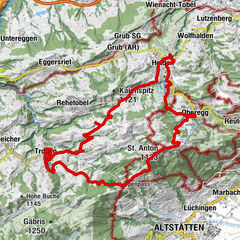
A wonderful circular e-bike tour for demanding bikers. From Thurgau it goes into eastern Switzerland to Appenzell/Weissbad and then along the Herzroute to Lake Constance. The route then follows the shores of the lake back to Thurgau.
- Highest point
- 1,109 m
- Endpoint
-
Wellnesshotel Golf Panorama, Lipperswil
- Height profile
-
 © outdooractive.com
 - Equipment
-
We recommend that you wear a helmet and take enough water and food with you. Also inform yourself about the weather conditions in advance.
- Tips
-
Accommodation in the following Private Selection Hotels:
Wellnesshotel Golf Panorama****S, Lipperswil Hotel Hof Weissbad****S Hotel Bad Horn****S on Lake Constance - Additional information
- Directions
-
Drive in the direction of "Connyland" in Lipperswil. Above the leisure park is the golf club and golf course of Lipperswil. A few metres away, situated above the golf course, you will discover the Wellnesshotel Golfpanorama.
- Public transportation
-
With the 2018 timetable change, the Wellness Hotel Golfpanorama will have its own Postbus stop. Line 833 stops at the Hattenhausen, Golfpanorama stop every hour from 06.00 in the morning until shortly before 21.00 in the evening. The bus line serves the Weinfelden-Lipperswil-Ermatingen route and the bus stop is approx. 5 to 10 minutes' walk from the Wellnesshotel Golfpanorama in Lipperswil.
- Parking
-
The car can be parked at the Hotel Golf Panorama.
-

-
AuthorThe tour Biketour Ostschweiz is used by outdooractive.com provided.


-
St. Gallen - Bodensee
288
-
Arbon
147
-
Häggenschwil
45