- Brief description
-
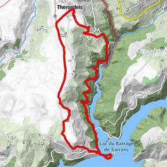
From the unique site of the Presqu?île de Laussac, this route takes us "up high" to offer some quite exceptional views of the Sarrans reservoir and the hamlet of Laussac.
- Difficulty
-
easy
- Rating
-
- Starting point
-
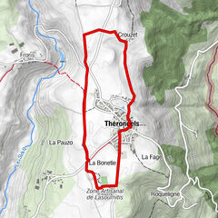
Thérondels
- Route
-
Jou2.7 km
- Best season
-
JanFebMarAprMayJunJulAugSepOctNovDec
- Description
-
Start: Presqu'île de Laussac car park
HIGHLIGHTS: Viewpoints and panoramic views of the Sarrans dam and Sarrans lake. Village of Jou: Typical hamlet and its restored work. The Laussac peninsula: Altarpieces and two 17th century chases containing the remains of Saint Gausbert in the church of Laussac. 15th-century historiated cross in the cemetery. Shaded picnic area. Pedalos, canoes, rowing boats, fishing, supervised swimming in summer.
DISCOVERY: Cantal de Thérondels Just outside the village of Thérondels, the cheese-making cooperative has been making a Cantal appellation cheese, a cousin of Laguiole, since 1948: Cantal de Thérondels (visit 05 65 66 02 88). Its production continues the tradition of farmhouse cheese made from raw milk on the farms of the plateau. The cooperative matures part of its production, and the taste varies according to the length of the maturing period. It offers young cheese (30 to 90 days), intermediate cheese (90 to 180 days) and old cheese (over 180 days). The rest of the production is sold at less than 30 days to wholesalers who complete the maturing process.
In 1950, 41 producers delivered 315,000 litres of milk for the production of Cantal cheese. In 1987, 1,500,000 litres were collected. Today the annual collection is 3,500,000 litres delivered by 20 producers. This Cantal is very popular in Parisian restaurants, and is also available at local markets. A great cheese to discover. For information on visits and direct sales, click here. The Presqu'île de Laussac: a Sensitive Natural Area Incredible biodiversity: 32 species of butterfly, including the Morio and the Black Damier, 14 species of mammal, including the European Otter.96 species of birds, including the Booted Eagle, the Honey Buzzard, the Red Kite, the Peregrine Falcon and the Black Woodpecker.
Included in the Natura 2000 site "Gorges de la Truyère", this area is home to species of heritage interest such as the Morio, the Pic mar and the Otter. An interactive guide, an application to download: Along the way, in addition to the information panels already on site, you'll be able to access a host of fact sheets on animal and plant species, as well as animal songs, even without an internet connection.After your visit, you can go further by testing your knowledge with the quizzes and watching the many films that will help you discover the incredible wealth of the Aveyron department.Discover all the sensitive natural areas in Aveyron: www.espacenature.aveyron.fr
- Directions
-
Markings: yellow + signs
- Highest point
- 897 m
- Endpoint
-
Thérondels
- Height profile
-
 © outdooractive.com
 - Safety instructions
-
In the event of a problem: call 112 (European emergency number)
- Additional information
-
Mur-de-Barrez Tourist Information Office
- Parking
-
Parking close to the starting point


- Author
-
The tour Hiking: The Jou trail is used by outdooractive.com provided.


General info
-
Cantal
222
-
Aubrac, Carladez et Viadène
108
")