- Difficulty
-
difficult
- Rating
-
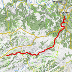
- Route
-
CahorsMas de Vers18.2 kmBach27.1 kmLaplane31.7 kmEscoutilles32.2 kmRigal32.2 kmCantecoucut32.3 kmVaraire32.3 km
- Highest point
- 322 m
- Height profile
-
 © outdooractive.com

- Author
-
The tour Jerusalemweg: Cahors - Varaire is used by outdooractive.com provided.
GPS Downloads


General info
Refreshment stop
Other tours in the regions
-
Lot
207