
- Brief description
-
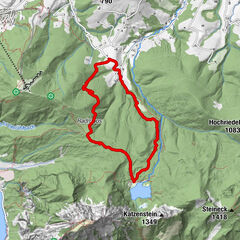
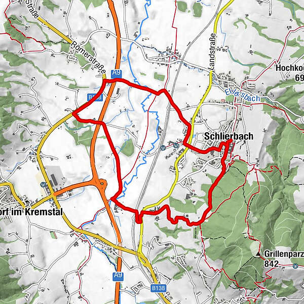
Hike in the picturesque Schlierbach floodplain.
- Difficulty
-
easy
- Rating
-
- Route
-
SchlierbachHolzofenpizzeria San Marco0.0 kmJausenstation Zeisl8.1 kmSPES9.0 kmGasthaus und Fleischerei Schröcker9.5 kmHolzofenpizzeria San Marco9.5 kmSchlierbach9.7 km
- Best season
-
JanFebMarAprMayJunJulAugSepOctNovDec
- Description
-
From the village square of Schlierbach past the train station and on to the Kastenmühle, the trail leads over a picturesque footbridge directly into the Schlierbach floodplain and through the "Weinberger" back to the starting point.
Trail number: K83, 47
- Directions
-
From the village square of Schlierbach you hike downhill directly to the train station and further to the Kastenmühle. From there, the path leads you over a picturesque footbridge directly into the Schlierbach floodplain landscape. Numerous rare, partly endangered plants and animals can be observed on your way.
After you have crossed a small forest, the path leads back into the atmospheric floodplain. Across the flat landscape you will then reach the Kremsuferstraße. Over a footbridge you reach the other side of the Krems, cross the Schlierbacher Landesstraße to take the slightly ascending path through the "vineyards" to the Jausenstation Zeisl. From there you return to your starting point.
- Highest point
- 542 m
- Height profile
-

- Tips
-
Climate-friendly to the National Park Region - railway station Schlierbach: By train you can reach the starting point for this hike in about 1 hour from Linz and in about 2.5 hours from Vienna.
- Directions
-
From Vienna/Salzburg: A1 towards Linz > A9 Pyhrnautobahn - exit Inzersdorf.
From Linz: A9 Pyhrn motorway - exit Inzersdorf
From Graz: A9 Pyhrnautobahn > exit Klaus > federal road B 138
- Public transportation
-
Arrival with the Pyhrnbahn, there are stops in Schlierbach, Kirchdorf/Krems and Micheldorf.
Details at www.ooevv.at
- Parking
-
Parking near the center
- Author
-
The tour Aurundweg is used by outdooractive.com provided.


General info
-
Traunviertel
1940
-
Tourismusregion Bad Hall
770
-
Schlierbach
299