Winter
Summer
Weather
Webcams
Accommodations
Tours
Search history
Search suggestions
No results found
Search
Tours
Home
Summer Österreich
Upper Austria
Tours
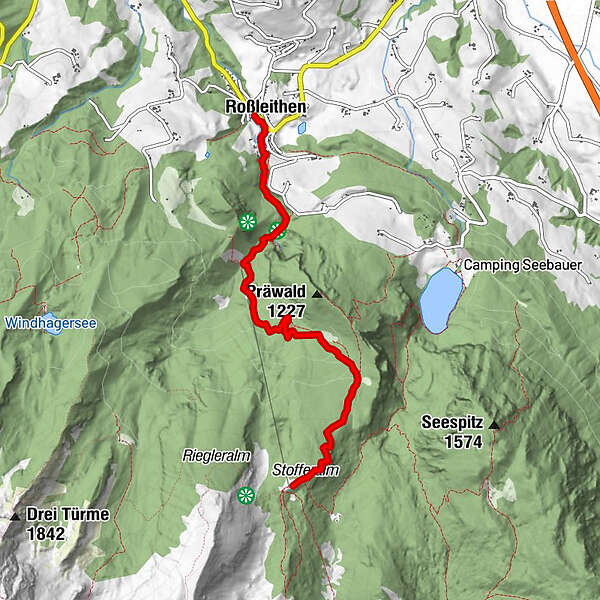
Roßleithen zur Dümlerhütte
Regions
Weather
Webcams
Tours
Highlights
Bathing lakes
Accommodations
Offers
Sports provider
Events
Ski resorts
Cross-country skiing
Snow parks
Roßleithen zur Dümlerhütte
Hiking
Bookmark
Map
show
hide
Print
Tour data
9.8
km
679 - 1,467
m
Distance
782
hm
782
hm
Ascent
01:15
h
Duration
pyhrn-priel
created am 17.01.2018
863
Views
Rating
Technique
Fitness
Landscape
Experience
Highest point
1,467 m
Write a review
Overall rating
5
0
%
4
0
%
3
0
%
2
0
%
1
0
%
Reviews
(0)
0 Comments
Write a review
Error
An error has occurred. Please try again.
Thank you for your review
Rating has been deleted
Report tour
GPS Downloads
GPX
GPS Exchange Format (XML)
KML
Google Earth, Google Maps
QR Download Codes for Mobile Phones
Roßleithen zur Dümlerhütte
QR Codes - tour download for cell phones
GPX
KML
Other tours in the regions
Traunviertel
1940
Urlaubsregion Pyhrn - Priel
1440
Roßleithen
463
Popular tours in the area
Bosruck - Grenzberg mit drei Gipfelkreuzen
difficult
Hiking
5.43
km |
1005
hm |
07:00
h
Wörschachklamm
easy
Hiking
4.67
km |
266
hm |
02:00
h
Hoher Nock
medium
Hiking
6.24
km |
1296
hm |
07:30
h
Gowilalm
medium
Hiking
5.6
km |
440
hm |
02:30
h
No entries found.
The search is currently not available.
Please refine your search.
Local search results
(<= 25km)
More results
(> 25km)
%count% Search results
%name%
%type%
%elevation%
%population%
%lpButton%